DOWNLOAD MY NEW FREE JOESTRADAMUS WEATHER APP FOR ALL DEVICES
THE APP IS ABSOLUTELY FREE TO ALL BUT CONSIDERING SUBSCRIBING TO PATREON FOR A WEATHER EXPERIENCE FREE OF ADS, EXCLUSIVE VIDEOS FOR MEMBERS ONLY AND MUCH MORE…STARTS AT $2 A MONTH..MESSAGE ME AT ANY TIME
Spring Pattern Continues Near 60 Today
Colder Damp Later Wednesday Thursday
The nice thing about the last few days is that the birds have been responding in song over the warmer temperatures. They are at it again this morning with as the sun attempts to break through the cloud cover. It is not a solid overcast and there isnt’t much on the radar at all near by. Lots of ground clutter showing up this morning which happens sometimes when you have a warm night especially aloft and the air near the ground is colder. That noise should disappear in a hurry. Winds will turn to the west and northwest this afternoon and we should see skies go partly to even mostly sunny. Temperatures should make a run into the 60s. The sea breeze today will be confined to south facing shore lines and may initially push inland but the west gradient should be tight enough to force the sea breeze out by late day.
EASTERN SATELLITE

REGIONAL RADAR

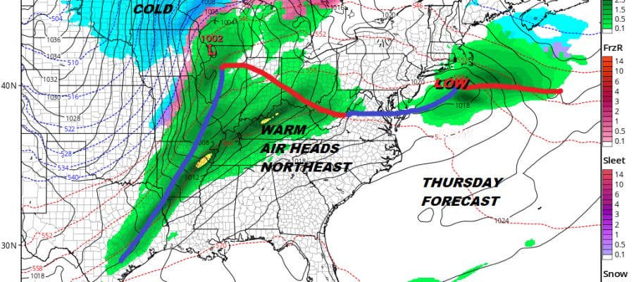
Spring to me is probably one of the uglier seasons in the first half at least when the cold ocean creates all sorts of problems as do back door cold fronts. Tonight Wednesday and Thursday we will play the negative scenario out as northeast winds bring in colder air tonight with lows in the 20s to lower 30s by morning. The front is stalled to the south and a wave develops on it so that means rain arrives by Wednesday late afternoon or evening.
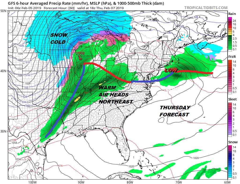
Unless there is a little freezing rain at the start in the colder Northern & Western Counties of New Jersey or in the Hudson Valley this should be all rain Wednesday night into Thursday morning. A wave develops on the warm front and that will keep things damp and raw. Wednesday and Thursday highs will be just in the 40s. The main low to the west tracks well west of us. I think we miss out on most of the showers with the cold front when that moves through Friday. We should see some improvement on Friday with clouds and some breaks of sun. It will be another day with highs into the 60s before much colder air arrives for the weekend.
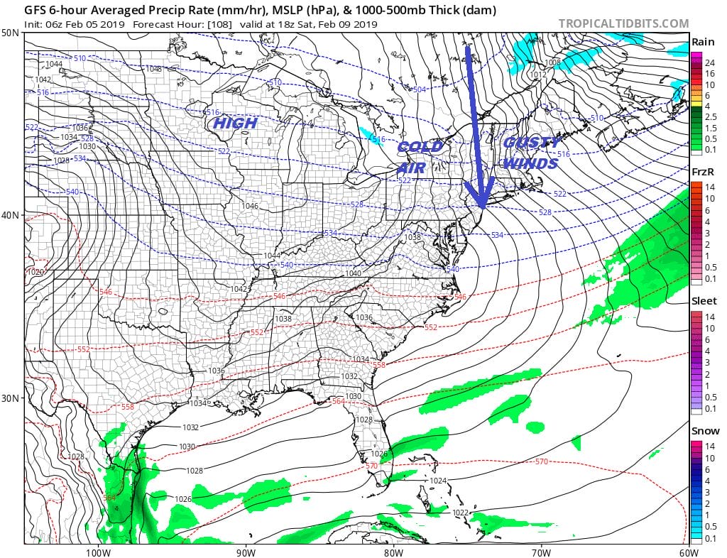
The weekend is looking like a winter weekend in February; cold dry with gusty winds on Saturday and less wind on Sunday High pressure rules with sunshine. Highs both days will be in the 30s and nights in the teens and low 20s.
WINDOW OF OPPORTUNITY FOR SNOW LOVERS NEXT WEEK
We have been getting the sense that next week may be the window of opportunity that snow lovers have been looking for as far as snow is concerned (such as it is). Cold air will be near or around us at least into early next week and the storminess in the west will lead a couple of systems to the east. This i believe is the only way snow is going to occur in that I-95 stretch from Boston to Philadelphia. Moving parts and perfect timing is what it boils down to. The European has the coldest and most bullish view of this but it stands in the face of completely opposite pictures painted by the GFS & Canadian models.
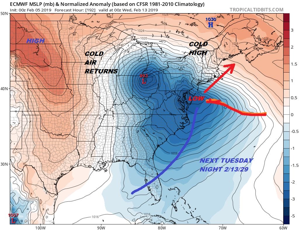
The European model has done what it has done at least half a dozen times in the 168-216 hr time frame and that is paint a snowstorm scenario for the Northeast US. Not a single time has this model been correct..not once..not even close. This flies in the face of the other models which have strong ridges in the Eastern US in this time frame verses the Europeans deep trough. The European’s solution flies in the face of everything we have seen regarding the overall weather pattern so for now I regard this idea with the highest of skepticism at this point. Meanwhile enjoy the day with highs reaching the 60s for the second day in a row.
MANY THANKS TO TROPICAL TIDBITS FOR THE USE OF MAPS
Please note that with regards to any tropical storms or hurricanes, should a storm be threatening, please consult your local National Weather Service office or your local government officials about what action you should be taking to protect life and property.


