DOWNLOAD MY NEW FREE JOESTRADAMUS WEATHER APP FOR ALL DEVICES
THE APP IS ABSOLUTELY FREE TO ALL BUT CONSIDERING SUBSCRIBING TO PATREON FOR A WEATHER EXPERIENCE FREE OF ADS, EXCLUSIVE VIDEOS FOR MEMBERS ONLY AND MUCH MORE…STARTS AT $2 A MONTH..MESSAGE ME AT ANY TIME
Spring Like Days Colder Pattern Weekend Next Week
The satellite loop shows a coastal storm off the North Carolina coast inching its way eastward. Once again thanks to a screaming west southwest jet from the Southeast coast to the Central Atlantic this storm heads out with no impact here. Actually it is having impact as it creates subsidence (sinking air) over head which means nice dry mostly cloud free skies. There is no cold air anywhere so temperatures are responding by climbing into the 50s. Local sea breezes will develop cooling things off on south facing shorelines. Radars are nice and quiet and we expect no issues into Tuesday. Temperatures tonight will settle in the 30s. Cold spots might see some condensation tonight with patchy fog and maybe even some black ice which was fairly common this morning in some areas.
EASTERN SATELLITE

REGIONAL RADAR

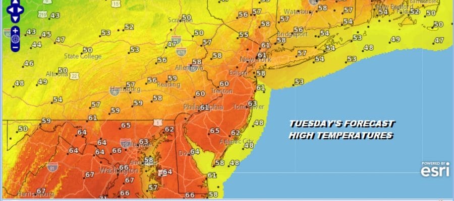
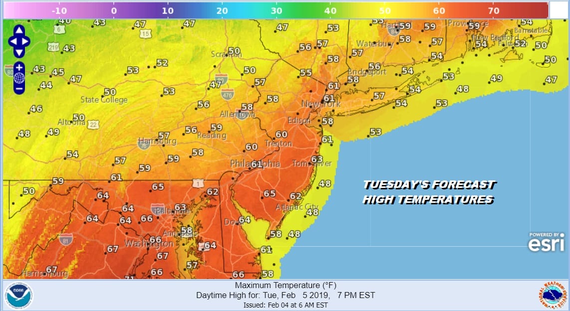
Tuesday brings a cold front through later in the day. There doesn’t seem to be much with it so with at least some sun into the afternoon we should see highs reach into the 60s with the exception again along south facing shorelines where the ocean wind will keep temperatures in the lower 50s and even in the 40s during the afternoon. The front comes through with not much fan fare. I don’t even think it is worth mentioning a shower with this.
On to the second half of the week. Some colder air returns Tuesday night but obviously nothing like we just had. In fact latest models push even less of the cold air southward which means the freezing rain threat for later Wednesday will be brief and confined to inland areas in Northwest New Jersey and parts of the Hudson Valley. Temperatures Wednesday morning will be in the upper 20s to mid 30s and then we should inch back into the 40s by late afternoon and evening. Some rain could move in by evening. Then it is on and off rain Thursday with temperatures in the 40s Thursday until the warm front comes through.
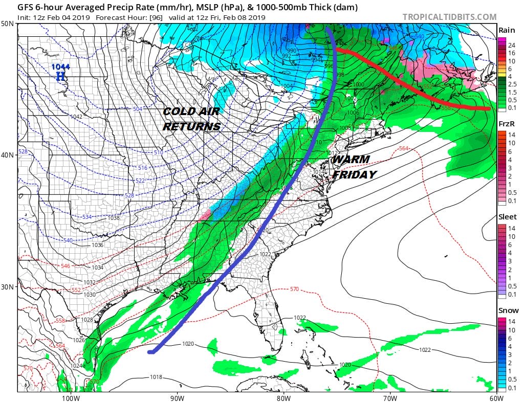
Friday could reach the 60s again until the cold front passes. Again it looks weak with not much too it. Then high pressure which you can see on the surface map over the Northern Plains with colder air sweeps in for the weekend with dry cold conditions and sunshine both Saturday and Sunday with highs in the 30s and lows in the teens to mid 20s.
NEXT WEEK PERHAPS A CHANCE FOR SNOW
Weather models seem to be circling on a chance for snow Monday night and Tuesday of next week as energy comes in from the west and with a flattening of the ridge in the east, it allows room for something to happen.
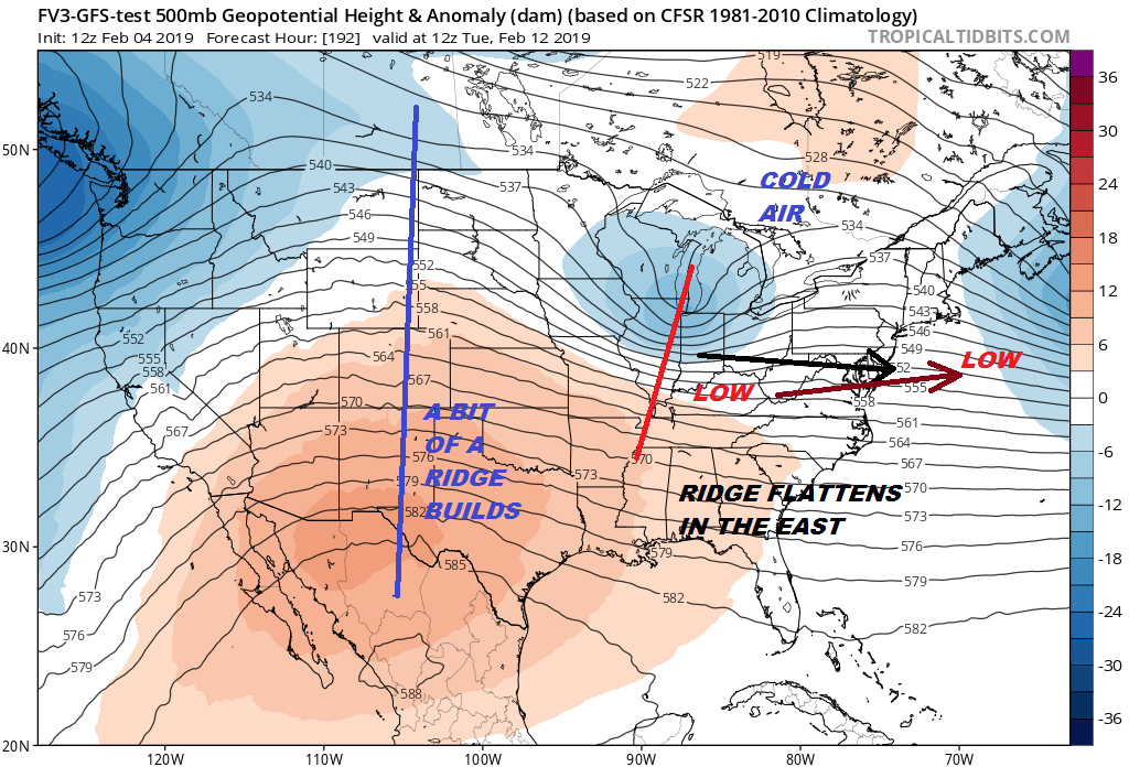
We have a week to watch this play out. The chances so far have been very few. That is the way the winter has been going. This could still wind up cutting to the west depending on all the other players. The wide open Atlantic jet stream is going to be an issue here. The upper air is not ideal. The European & GFS models seem to be on the same page. The Canadian keeps a strong ridge in the East and the storm cuts well to the west. That certainly could be the outcome here if the East Coast ridge is too strong or the trough to the west too deep. It is something to watch in the coming days but nothing to get worked up about at the moment.
MANY THANKS TO TROPICAL TIDBITS FOR THE USE OF MAPS
Please note that with regards to any tropical storms or hurricanes, should a storm be threatening, please consult your local National Weather Service office or your local government officials about what action you should be taking to protect life and property.


