Spotty Showers Jose Latest Advisory Weekend Outlook
Spotty Showers Jose Latest Advisory Weekend Outlook
The remnants of Hurricane Irma have been completely underwhelming. While there is still evidence of a weak circulation to the west it is exactly that…weak. Some spotty showers are showing up on radars this evening but other than that it is relatively quiet and cloudy around the area tonight with warm humid conditions. The overnight will be warm and humid with patchy fog and temperatures in the 60s. Some 50s are possible in cooler northwest counties of New Jersey but overall its the 60s for everyone.
SATELLITE LOOP

REGIONAL RADAR

LOCAL RADAR NEW YORK CITY

LOCAL RADAR PHILADELPHIA


With the remaining Irma circulation continuing to weaken on Friday we are going to leave in the chance for an odd downpour or a thunderstorm but it should be scattered like today and most of you won’t see anything. Temperatures will be in the upper 70s to lower 80s with the humidity still on the high side. Saturday could be a repeat of Friday though I think we will see a bit more sun and a bit less cloud cover and the chance for a pop up downpour. Sunday looks nice and sunny with highs into the 80s. It might be a pretty good beach weekend for the last weekend of summer were it not for the rip currents from Hurricane Jose so be cautious at the shore.
JOSE SATELLITE LOOP

Speaking of Jose it weakened to a tropical storm this morning as wind shear has taken a bit of a toll on it. However weather models forecast that shear to relax overnight and Friday and Jose should strengthen back to a hurricane. We still do not have clarity as to what will ultimately happen with Jose other than it is going to turn northward by Sunday and come very close to us later Tuesday into Tuesday night.

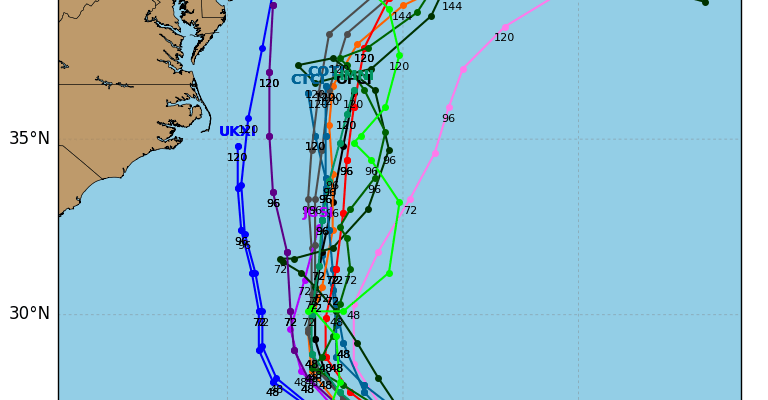
While the afternoon hurricane track models are clustered offshore they have come back in a bit westward and we are seeing a couple of the hurricane track models come perilously close to the coast. I am leaning to an offshore track right now but only leaning while looking over my shoulder at the same time.
LATEST TROPICAL STORM JOSE ADVISORY
…LIFE-THREATENING RIP CURRENTS POSSIBLE ALONG PORTIONS OF THE
U.S. EAST COAST FROM JOSE…
SUMMARY OF 500 PM AST…2100 UTC…INFORMATION
———————————————-
LOCATION…25.2N 67.3W
ABOUT 405 MI…650 KM ENE OF THE SOUTHEASTERN BAHAMAS
ABOUT 515 MI…825 KM SSW OF BERMUDA
MAXIMUM SUSTAINED WINDS…70 MPH…110 KM/H
PRESENT MOVEMENT…WNW OR 290 DEGREES AT 8 MPH…13 KM/H
MINIMUM CENTRAL PRESSURE…989 MB…29.21 INCHES
WATCHES AND WARNINGS
——————–
There are no coastal watches or warnings in effect.
Interests from North Carolina northward to New England on the east
coast of the United States should monitor the progress of this
system.
DISCUSSION AND 48-HOUR OUTLOOK
——————————
At 500 PM AST (2100 UTC), the center of Tropical Storm Jose was
located near latitude 25.2 North, longitude 67.3 West. Jose is
moving toward the west-northwest near 8 mph (13 km/h), and this
motion is expected to continue through Friday, followed by a turn
to the northwest on Saturday.
Maximum sustained winds remain near 70 mph (110 km/h) with higher
gusts. Some restrengthening is forecast to begin on Friday, and
Jose will likely become a hurricane again by the weekend.
Tropical-storm-force winds extend outward up to 140 miles (220 km)
from the center.
The estimated minimum central pressure is 989 mb (29.21 inches).
HAZARDS AFFECTING LAND
———————-
SURF: Swells generated by Jose are affecting Bermuda, the Bahamas,
the northern coasts of Hispaniola and Puerto Rico, and the Southeast
coast of the United States, and will spread northward along the
Mid-Atlantic coast of the U.S. during the next few days. These
swells are likely to cause life-threatening surf and rip current
conditions. For more information, please consult products from your
local weather office.
NEXT ADVISORY
————-
Next complete advisory at 1100 PM AST.
 GET JOE A CIGAR IF YOU LIKE

FiOS1 News Weather Forecast For Long Island
FiOS1 News Weather Forecast For New Jersey
FiOS1 News Weather Forecast For Hudson Valley


