DOWNLOAD MY NEW FREE JOESTRADAMUS WEATHER APP FOR ALL DEVICES
THE APP IS ABSOLUTELY FREE TO ALL BUT CONSIDERING SUBSCRIBING TO PATREON FOR A WEATHER EXPERIENCE FREE OF ADS, EXCLUSIVE VIDEOS FOR MEMBERS ONLY AND MUCH MORE…STARTS AT $2 A MONTH..MESSAGE ME AT ANY TIME
Some Sun Next 2 Days Minimal Shower Chance Friday
Yesterday’s snow & ice fest is now gone as low pressure intensifies to the northeast/ The pressure gradient tightens up today so look for gusty winds, clouds and some sunshine. The air behind this system is chilly but not overly cold so highs today should reach into the 40s and that will help melt away yesterday’s couple of inches of snow and ice that accumulated.

Radars have gone quiet but we do have lots of clouds around this morning on the satellite picture that extends back to the Great Lakes. Snow is showing up on the regional radar in upstate NY & also in Maine. There are also some snow showers in Western Pennsylvania and in parts of Western NY. Otherwise radars will remain quiet for today.
EASTERN SATELLITE

REGIONAL RADAR

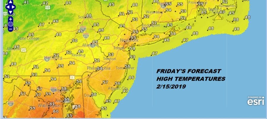
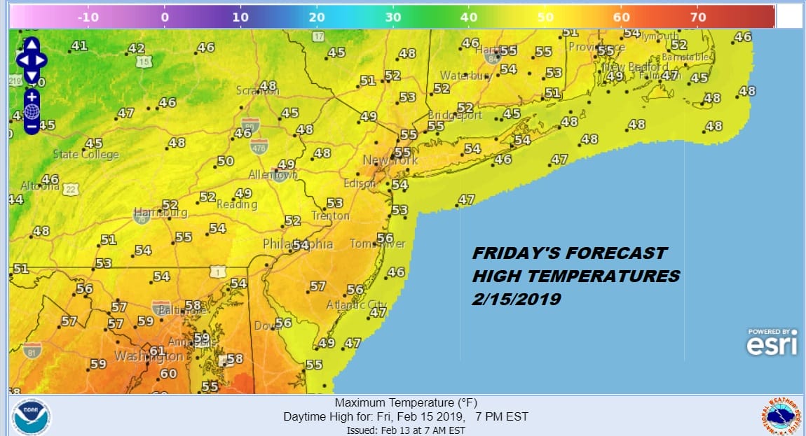
Temperatures tonight won’t drop too far tonight with most lows in the 20s as skies partially clear out. Thursday high pressure will be along the East Coast so we should see some sunshine with highs in the 40s. Then a weather front approaches on Friday with clouds Thursday night into Friday. A cold front approaches and comes through late in the day but other than clouds it doesn’t appear that the front will have much with it. Temperatures have no where to go but up Friday so we should see highs in the 50s and in some cases well up into the 50s.
Over the weekend the first of several weather systems will be moving along. This one passes south of here across Virginia & North Carolina. This system also looks weak overall as it moves to the East and offshore.

Two other systems follow next week that might produce a higher chance of snow or rain. While the overall large scale pattern remains largely the same (trough west, ridge east) there appears to enough of a relaxation in that pattern to open the door to these opportunities for winter weather in the East. over the next week to 10 days. This then takes us almost to the end of the month of February. Nothing in the pattern suggests that any of these systems in the short term are major system. They all appear to be minor in nature at this point.
MANY THANKS TO TROPICAL TIDBITS FOR THE USE OF MAPS
Please note that with regards to any tropical storms or hurricanes, should a storm be threatening, please consult your local National Weather Service office or your local government officials about what action you should be taking to protect life and property.


