SNOW WINTER STORM WARNING COASTAL NORTHEAST
SNOW WINTER STORM WARNING COASTAL NORTHEAST
WINTER STORM WARNING LONG ISLAND
WINTER STORM WARNING NEW JERSEY COAST OCEAN COUNTY TO CAPE MAY
WINTER STORM WARNING COASTAL CONNECTICUT EAST OF BRIDGEPORT
AND ALL OF EASTERN CONNECTICUT EAST OF I-91
WINTER WEATHER ADVISORY NEW YORK CITY, SOUTHERN HUDSON VALLEY
WINTER WEATHER ADVISORY NEW JERSEY SOUTH AND EAST OF I-95
WINTER WEATHER ADVISORY SOUTHEASTERN PENNSYLVANIA INCLUDING PHILADELPHIA
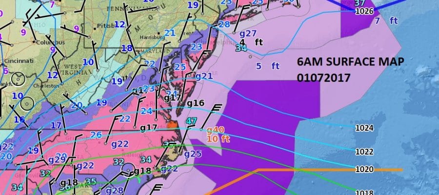
Everything is loading up this morning on the radar. Winter Storm Warning in effect for the coastal areas of the Northeast from Norfolk Va to Boston. in fact it is a little unusual but we have Blizzard Warnings up for Southeastern Virginia and Southeastern New England at the same time! That doesn’t happen too often. The extent of Winter Storm Warnings is large this across the Eastern United States.
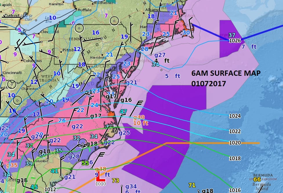
Everything to me seems on course this morning for a 4 to 8 inch snowfall along the coast and for lesser amounts as we head inland north and northwest. Remember the cutoff will be very sharp. Snow is spreading northward now through New Jersey and will be developing later this morning around New York City and Long Island before it pushes further north and northeast.


I’ve made no changes at all to my snow forecast map at this time. The cutoffs north and west are very sharp so you will go from a coating to a few inches to 6 inches over a relatively short distance.However I don’t think the cut off will be as sharp as it was in the half blizzard 2 years ago or in last year’s blizzard where in some places you could have walked the distance from a coating to 6 inches to 1 foot as it was a matter of miles. This I think is going to be a more gradual cutting off because you do not have a well developed surface low here.
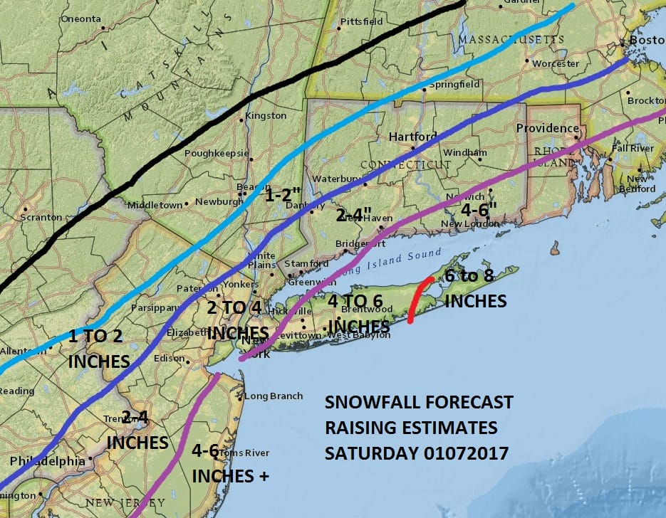
The maps below are the National Weather Service forecast snow maps with the most likely snowfall prediction.


The European model last night had a rather more generous view of snowfall as it had the back edge of 3 to 6 much further west than the other models. I think from here It really is just a matter of watching what is happening right overhead. Snow will taper off from west to east between 7pm and 11pm and then it will be bitter cold with lows in the low to mid teens by Sunday morning. Sunday will be windy and biting cold with some sun but I think there will be some snow showers Sunday that could whiten the ground in spots. Highs will be just into the 20s. Then its a trip down to low teens and single digits Monday morning. Monday we will see some sunshine with highs in the mid 20s to near 30.
SNOW REMOVAL COMPANIES FOR YOUR WINTER NEEDS
LONG ISLAND ROCKLAND COUNTY Connecticut

![]()

ROCKLAND COUNTY TRI STATE SNOW REMOVAL jOHNSTOWN PA


