
Snow Threat Friday Weakest of the 3

Snow Threat Friday Weakest of the 3
With what appears to be 3 snow threats for the Middle Atlantic States & Southern areas of the Northeast the first of the 3 events appears to the the WEAKEST of the bunch. All of the systems in play are going to hinge on the strength of blocking over Greenland and how strong that blocking is or isn’t. A stronger block would be colder but it would also suppress weather systems further south. A weaker block and we have systems that move further north.
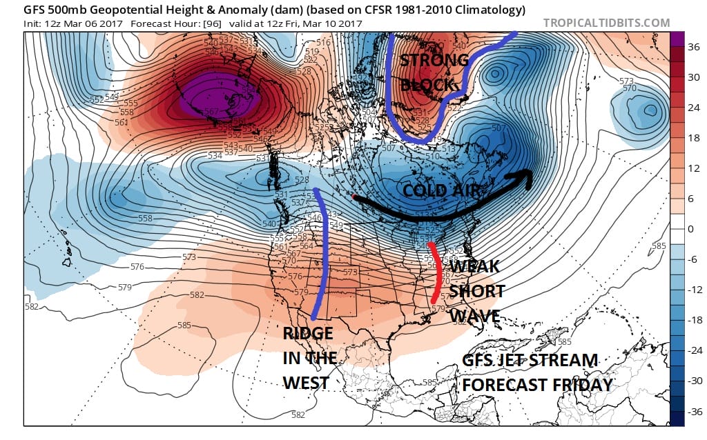 Weather models seem to all be showing a narrow band of snow for Friday. The European which through last night showed nothing with this lead system now has some snow from NYC & Long Island southward. The Canadian and GFS model are similar in their tracks. The Canadian was way north with this through last night and now lines up with the GFS.
GFS MODEL FRIDAY SNOW THREAT SURFACE FORECAST
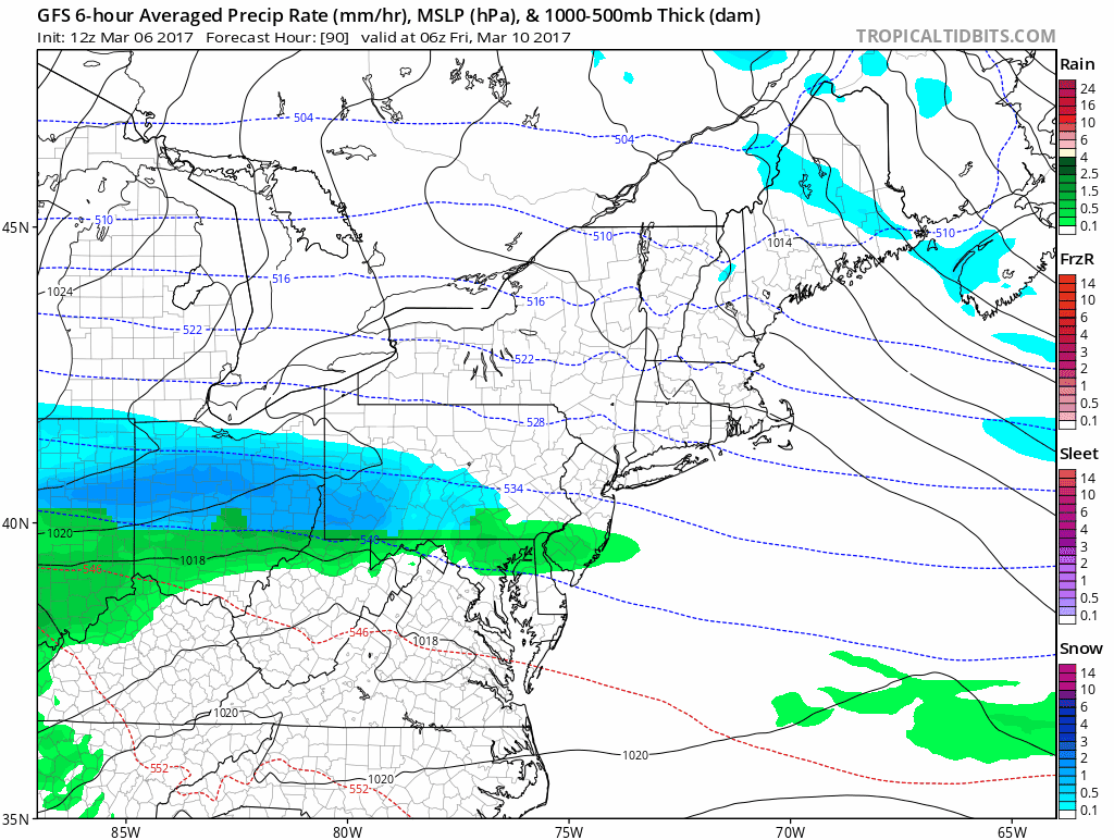
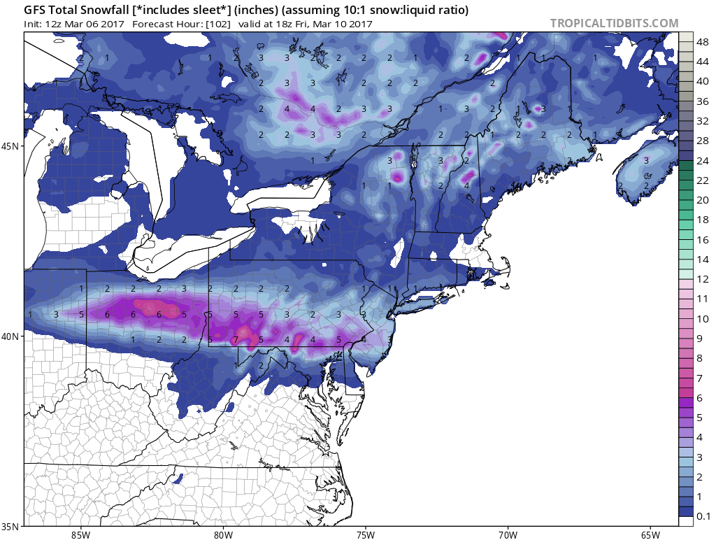
The GFS model snow forecast & The Canadian model snow forecast line up pretty well with the European model showing half this amount. My own feeling is that for now this has the potential for a coating to a couple of inches. This is an early guess based on what is going on with weather model runs today.
GFS SNOW FORECAST FRIDAY
Once this system goes by the next one approaches on Sunday and we will address that system later today once all weather model runs are done. The second weather system will impact on Sunday and JOESTRADAMUS has more on this.
MANY THANKS TO TROPICAL TIDBITS FOR THE WONDERFUL USE OF THE MAPS

GET JOE A CIGAR IF YOU LIKE!
SNOW REMOVAL COMPANIES FOR YOUR WINTER NEEDS
LONG ISLAND ROCKLAND COUNTY Connecticut

![]()

ROCKLAND COUNTY TRI STATE SNOW REMOVAL JOHNSTOWN PA


FiOS1 News Weather Forecast For Long Island
FiOS1 News Weather Forecast For New Jersey
FiOS1 News Weather Forecast For Hudson Valley
NATIONAL WEATHER SERVICE SNOW FORECASTS
LATEST JOESTRADAMUS ON THE LONG RANGE
Weather App

Don’t be without Meteorologist Joe Cioffi’s weather app. It is really a meteorologist app because you get my forecasts and my analysis and not some automated computer generated forecast based on the GFS model. This is why your app forecast changes every 6 hours. It is model driven with no human input at all. It gives you an icon, a temperature and no insight whatsoever.
It is a complete weather app to suit your forecast needs. All the weather information you need is right on your phone. Android or I-phone, use it to keep track of all the latest weather information and forecasts. This weather app is also free of advertising so you don’t have to worry about security issues with your device. An accurate forecast and no worries that your device is being compromised.
Use it in conjunction with my website and my facebook and twitter and you have complete weather coverage of all the latest weather and the long range outlook. The website has been redone and upgraded. Its easy to use and everything is archived so you can see how well Joe does or doesn’t do when it comes to forecasts and outlooks.
Just click on the google play button or the apple store button on the sidebar for my app which is on My Weather Concierge. Download the app for free. Subscribe to my forecasts on an ad free environment for just 99 cents a month.
Get my forecasts in the palm of your hand for less than the cost of a cup of Joe!
![]()
