DOWNLOAD MY NEW FREE JOESTRADAMUS WEATHER APP FOR ALL DEVICES
THE APP IS ABSOLUTELY FREE TO ALL BUT CONSIDERING SUBSCRIBING TO PATREON FOR A WEATHER EXPERIENCE FREE OF ADS, EXCLUSIVE VIDEOS FOR MEMBERS ONLY AND MUCH MORE…STARTS AT $2 A MONTH..MESSAGE ME AT ANY TIME
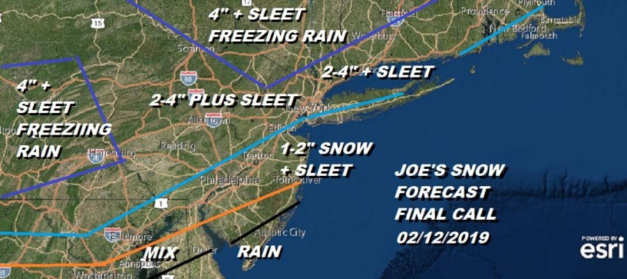
Snow Sleet Freezing Rain Joe’s Final Call 02122019
After all the consternation and torture of weather model nonsense during the last week my final call is up. I basically massaged the numbers a little bit. It will all hinge on how much cold air can wedge southward tonight. I think enough will to produce a few inches of snow..some places get a bit more and then a change to sleet which could last for several hours or longer and then to rain along the coast. Freezing rain will be an issue inland until the temperatures get above 32.

Across Southern Pennsylvania and Southern half of New Jersey this is in addition to what fell overnight into Monday morning. Then it is a change to sleet during the morning hours..it should change in Philadelphia around 10am or so.
Around NYC & Long Island snow develops tomorrow morning during the morning commute between 7am and 10am (light at first) and then continues until about 1-2pm and changes to sleet there and on Long Island. The change to sleet in New Jersey occurs around 195 around 9-10am..and then only edges slowly northward. A change to rain should occur in NYC around 5-6pm ish. Obviously temperatures are going to be key here and how long it takes to get above freezing will make a bit of a difference in some areas. The rain comes tomorrow night on and off and washes some of this stuff away.
EASTERN SATELLITE

REGIONAL RADAR

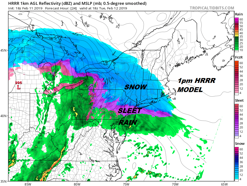
We are socked in with clouds right now and to the south we have the east west band of precipitation across Maryland and Southern Pennsylvania. This area should begin to expand and push northward this evening so look for a pick up on the local radars tonight.
LOCAL RADAR NEW YORK CITY

LOCAL RADAR PHILADELPHIA


This all ends by early Wednesday morning. Weather conditions improve as we go through the day. There isn’t much cold air behind this so temperatures will warm into the 40s and melt whatever hasn’t been washed away. We should see some sunshine both Wednesday and Thursday before rain arrives Friday.
joeMANY THANKS TO TROPICAL TIDBITS FOR THE USE OF MAPS
Please note that with regards to any tropical storms or hurricanes, should a storm be threatening, please consult your local National Weather Service office or your local government officials about what action you should be taking to protect life and property.


