Snow Saturday Winter Weather Advisory 12092017
SHOP THE JOESTRADAMUS STORE
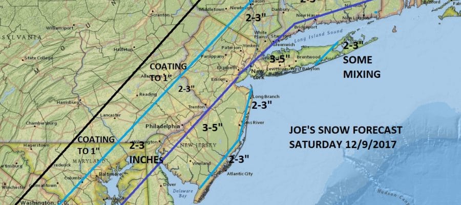
Snow Saturday Winter Weather Advisory 12092017
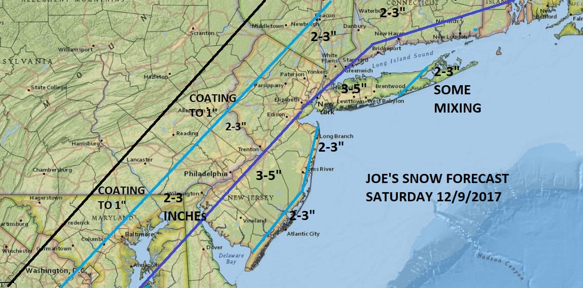
My snow forecast map is above and as always with these things there is a great deal of uncertainty and difficulty in figuring it all out. This is going to bust somewhere. All snow forecasts busts for somewhere; you can’t making them exactly perfect. I think this is the best bet. The only change I made is that right on the immediate coast of New Jersey I went a shade lower if only to allow for a bad wind for a few hours. It may or may not make a difference in the end. For Long Island the issue may be mixing though that too is problematic since even if mixing occurs it is likely to change back to snow late in the day Saturday. I went a bit less to the east. North and west the issue is how far west and where does the bakc edge of the snow get. I may not be far enough west with that back edge and the 2-3 inch line could wind up adjusting northwestward. Those are the issues with this particular set up.
SATELLITE LOOP

Moisture is loading up on the satellite loop and high clouds are moving northeastward so look for sunshine to fade behind increasing clouds today. Temperatures will be impacted by cloud cover and are likely to not make it much above the upper 30s to around or in some places just over 40.
REGIONAL RADAR

Radars are actually showing precipitation (snow) aloft not that far away though the steady precipitation in the form of rain is still well to the south.
LOCAL RADAR NEW YORK CITY

LOCAL RADAR PHILADELPHIA


Snow develops overnight in Southern New Jersey and Southeastern Pennsylvania and then begins to back northwestward from the southeast around daybreak or just before for NYC & Long and shortly after that it arcs back westward to the Pennsylvania New Jersey border, up the Hudson Valley to Route 84 and into Connecticut and Southern New England. Snow could mix over Eastern Long Island by mid to late morning and then it is a matter of how far west the mixing gets. Some numerical models keep it all snow at Islip & Farmingdale with the mixing east of here. Others bring mixing west toward NYC later in the afternoon for a brief time. Either way it should change back to all snow and then gradually end from west to east between 7pm and 1am as the low shifts eastward.
Temperatures overnight will be in the mid 20s to lower 30s in most places and stay mainly in the lower 30s on Saturday (plus or minus a degree). Weather conditions improve Sunday with clouds and some sunshine. and highs in the 30s to near 40. Monday will be dry and chilly. Another storm system approaches for Tuesday and we will address that in some form later today. The part that we are sure of with the next one is that it will turn very cold Tuesday night into Thursday with highs Wednesday and Thursday just in the 20s.
This system is impacting areas from the Middle Atlantic States to Northern New England. You can check out the National Weather Service snowforecast maps for additional information.
 GET JOE A CIGAR IF YOU LIKE

FiOS1 News Weather Forecast For Long Island
FiOS1 News Weather Forecast For New Jersey
FiOS1 News Weather Forecast For Hudson Valley


