Snow Possibilities Next Week Pattern Turns Colder

Snow Possibilities Next Week Pattern Turns Colder
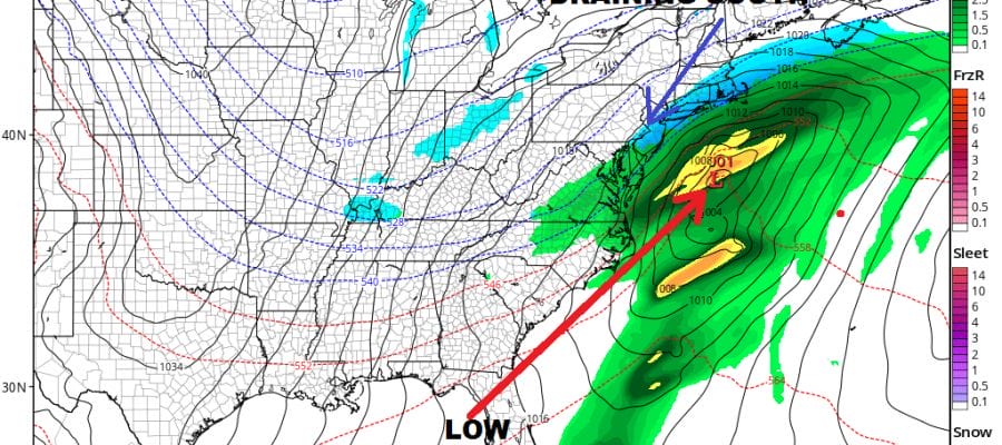
The grinding process of pattern realignment continues and we are continuing to see the indicators pointing to a pattern similar to the pattern from mid December to mid January. Everything appears to be moving right on course. The first system comes later Monday into Tuesday and it is yet another example of weather models initially showing an offshore low and then gradually reeling it in westward.
SNOW POSSIBILITIES NEXT WEEK GFS MONDAY JANUARY 29 2018

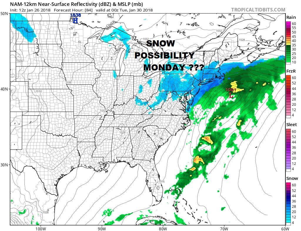
The GFS is probably the warmest of all the models today with a slightly flatter track to the east and a sharp western edge for snow along the immediate coast. Cold air will be draining southward on Monday. The NAM has a colder look overall especially at the bottom of the atmosphere. It also seems to do a bit more with intensity through Monday evening as snow breaks out on this model from Southern New England to the Delmarva Peninsula.
SNOW POSSIBILITIES NAM MODEL MONDAY JANUARY 29 2018
Complicating all this is the upper air trough that is swinging eastward. Some models develop a separate area of snow with this but this is always very problematic in trying to forecast the impact if any. For now we will place more emphasis on the developing coastal low. As to amounts it seems that a 1 to 3 inch snow fall is possible with the greatest chances along the coastal areas. Since so many issues are borderline and muddled, we will wait to make an early call on this.
LONG RANG EAST PACIFIC OSCILLATION
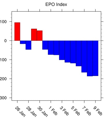
Longer range teleconnection indices continue to show a crashing East Pacific Oscillation index which points to colder in the Eastern US. The big surprise today came from the Pacific North America index or PNA which is now far less negative and actually turns positive toward the end of the forecast period.
PACIFIC NORTH AMERICA INDEX
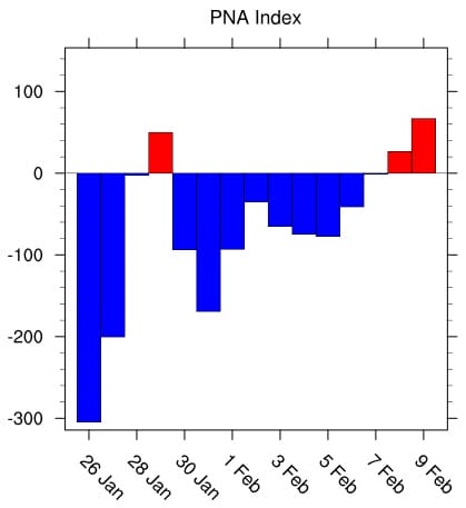
This change in the Pacific North America index puts another check mark in below average temperatures taking hold in the East as we move into February. We also continue to see models occasional dropping the jet stream back in the west as the European model does today. This would favor warmer air coming back toward the end of the forecast period.
JET STREAM EUROPEAN MODEL MONDAY FEBRUARY 5 2018

We do not believe this idea at all as it would go against the signals of the teleconnections as well as other indices. The GFS and the GFS ensembles both show near or below average temperatures beginning next weekend and lasting at least through February 11th which is as far as the models go at this point.
There is a second threat late next week just in time for National Glorify A Rodent day (Groundhog Day February 2) which involves a weather front and a wave of low pressure developing on it. We will wait to work out the details with the first system on Monday before we focus on the second.
MANY THANKS TO TROPICAL TIDBITS FOR THE WONDERFUL USE OF THE MAPS

GET JOE A CIGAR IF YOU LIKE!
FiOS1 News Weather Forecast For Long Island
FiOS1 News Weather Forecast For New Jersey
FiOS1 News Weather Forecast For Hudson Valley
NATIONAL WEATHER SERVICE SNOW FORECASTS
LATEST JOESTRADAMUS ON THE LONG RANGE
Weather App

Don’t be without Meteorologist Joe Cioffi’s weather app. It is really a meteorologist app because you get my forecasts and my analysis and not some automated computer generated forecast based on the GFS model. This is why your app forecast changes every 6 hours. It is model driven with no human input at all. It gives you an icon, a temperature and no insight whatsoever.
It is a complete weather app to suit your forecast needs. All the weather information you need is right on your phone. Android or I-phone, use it to keep track of all the latest weather information and forecasts. This weather app is also free of advertising so you don’t have to worry about security issues with your device. An accurate forecast and no worries that your device is being compromised.
Use it in conjunction with my website and my facebook and twitter and you have complete weather coverage of all the latest weather and the long range outlook. The website has been redone and upgraded. Its easy to use and everything is archived so you can see how well Joe does or doesn’t do when it comes to forecasts and outlooks.
Just click on the google play button or the apple store button on the sidebar for my app which is on My Weather Concierge. Download the app for free. Subscribe to my forecasts on an ad free environment for just 99 cents a month.
Get my forecasts in the palm of your hand for less than the cost of a cup of Joe!