
DOWNLOAD MY NEW FREE JOESTRADAMUS WEATHER APP FOR ANDROID
THE APP IS ABSOLUTELY FREE TO ALL BUT CONSIDERING SUBSCRIBING TO PATREON FOR A WEATHER EXPERIENCE FREE OF ADS, EXCLUSIVE VIDEOS FOR MEMBERS ONLY AND MUCH MORE…STARTS AT $2 A MONTH..MESSAGE ME AT ANY TIME
Snow Passing South
Warm Up Into Tuesday Long Range Muddled Midweek On
We are watching an area of snow this morning passing to the south of us across Southern Pennsyvlania into Maryland and Delaware. Winter Weather Advisories are posted for these areas. It is so cold we have it snowing with temperatures in the single digits to near 10 which is something we don’t often see. Further north the cloud line is fairly sharp and skies across Northeastern Pennsylvania to Southern New England were clear for most of the night. Some places saw their winds drop off to dead calm and this led to low temperatures as low as 10 below zero just inland.
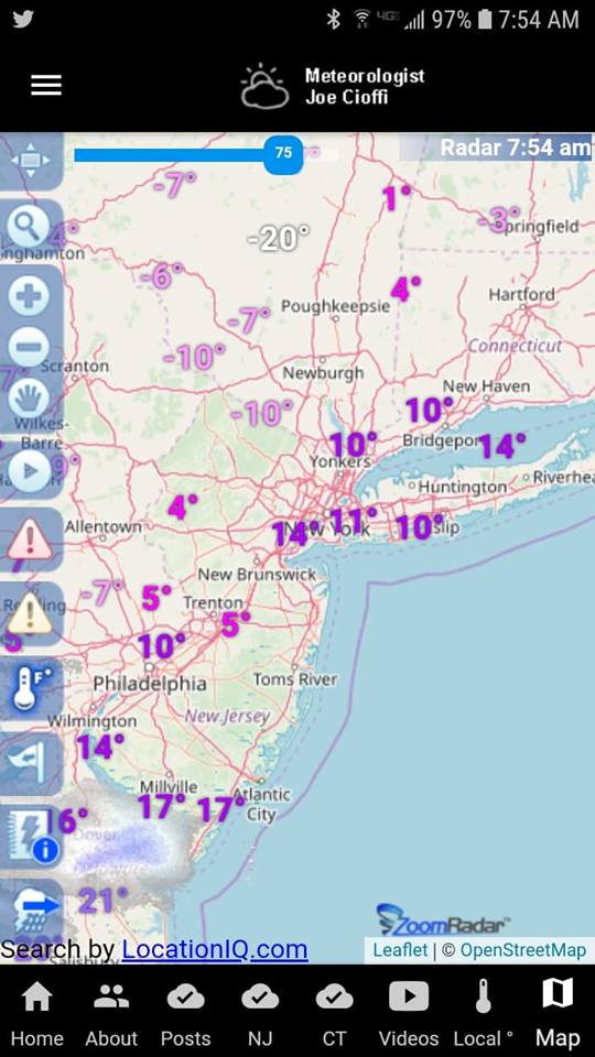
Satellite and radar loops are picking up on the area of snow that is moving east. This is being produced by warm air aloft racing eastward. There isn’t much support with this and the intensity of the arctic air mass is creating snow with the slightest push of warm air coming east. This will play itself through this afternoon and probably get no further north than Route 195 in New Jersey and Route 76 in Pennsylvania.
EASTERN SATELLITE

REGIONAL RADAR

We are seeing some of that snow on the local radars this morning as it is now in range of the Fort Dix Radar. Snow is over Southern New Jersey and in Southeastern Pennsylvania and much of it is on the light side.
LOCAL RADAR NEW YORK CITY

LOCAL RADAR PHILADELPHIA


For most areas today it will be sun and high clouds with high temperatures reaching into the 20s for the first time in the last 2 days. From here forward it is a stair step climb in temperatures. Tonight will be very cold with single digits and teens for lows under clear skies. Saturday we start climbing with highs in the low to mid 30s with some sunshine.

Temperatures Saturday night are not likely to fall very much and with some sunshine Super Bowl Sunday, highs will be into the 40s. Upper 40s to lower 50s is doable Monday and the next cold front arrives on Tuesday and we will start to see a trend to colder again though not bitter cold developing for the second half of next week.
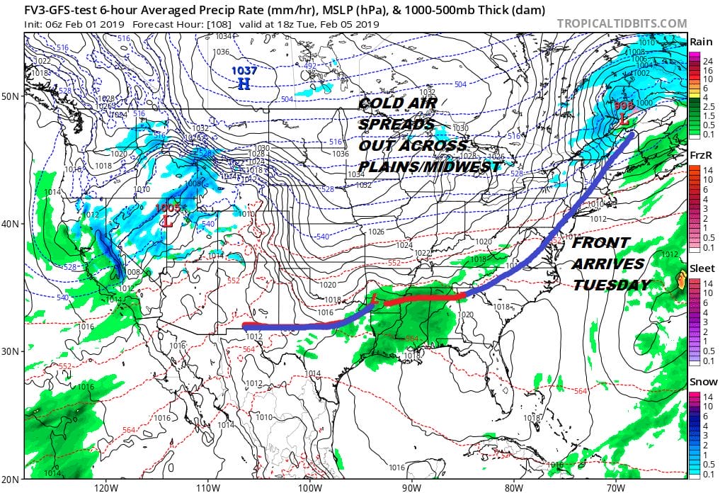
Long range after this front passes is a bit of a toss up. While the air aloft will likely be warm, the air at the surface may not be. This could complicate things later next week as we start to see waves of low pressure coming our way with a frontal boundary near or just to the south of us. Nothing of consequence is in the forecast through at least Tuesday of next week so we will enjoy the break in the bitter cold.
MANY THANKS TO TROPICAL TIDBITS FOR THE USE OF MAPS
Please note that with regards to any tropical storms or hurricanes, should a storm be threatening, please consult your local National Weather Service office or your local government officials about what action you should be taking to protect life and property.


