Snow Long Island Coastal & Southeastern Connecticut Overnight

Snow Long Island Coastal & Southeastern Connecticut Overnight
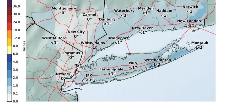
Just enough of the coastal low offshore is bending back westward that it is producing some mixed precipitation in parts of Central & Southern New Jersey. Over Long Island as well as coastal and Eastern Connecticut we are seeing some steady snow with temperatures that are now near or just below the freezing mark. This should be enough to produce a coating to a couple of inches overnight and into the Tuesday morning commute. At the same time we have an upper air disturbance evident on the satellite loop moving into Western Pennsylvania and that will probably produce a coating to an inch or 2 of snow for some inland areas during the day on Tuesday before all of this head offshore and to the east.
US SATELLITE

REGIONAL RADAR

Radar loops show the coastal moisture from the Delmarva Peninsula northeast to Long Island, Southern Connecticut and Rhode Island moving northeastward though the western edge at the moment is not making much eastward progress. The snow to the west in Pennsylvania is pivoting to the east with not much happening in between.
LOCAL RADAR NEW YORK CITY

LOCAL RADAR PHILADELPHIA


Look for snow to taper off at the coast tomorrow morning while the area to the west will march across into New Jersey from the west before it weakens later in the day. Temperatures will be hovering close to critical levels overnight and much of the day on Tuesday. Then skies should clear Tuesday night as it turns much colder. By Wednesday morning lows should be in the teens and low 20s. Sunshine returns on Wednesday with highs just into the 30s.
The next front approaches on Thursday with arriving clouds and highs back into the 40s. Some rain will develop Thursday night that could change to snow once the front passes. This does not look to be a big deal unless some sort of wave develops on the front at the last minute. Then it will be colder Friday and into the weekend. Another arctic boundary arrives on Sunday and stalls and low pressure developing on that front could bring some snow here next Monday. We will have more on this Tuesday as we sort everything out.
 GET JOE A CIGAR IF YOU LIKE

FiOS1 News Weather Forecast For Long Island
FiOS1 News Weather Forecast For New Jersey
FiOS1 News Weather Forecast For Hudson Valley


