Snow Freezing Rain Moving Northward 02072018
Snow Freezing Rain Moving Northward 02072018
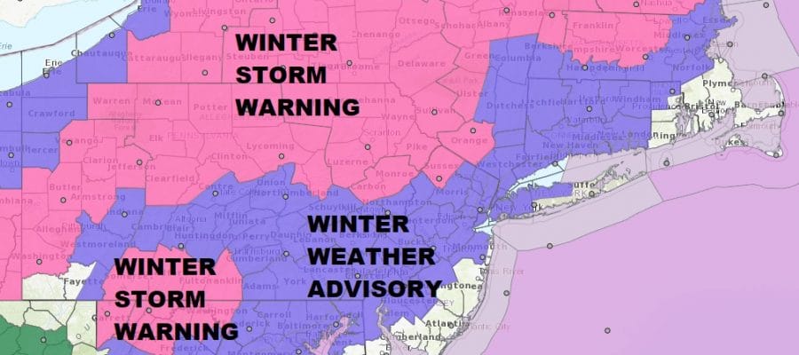
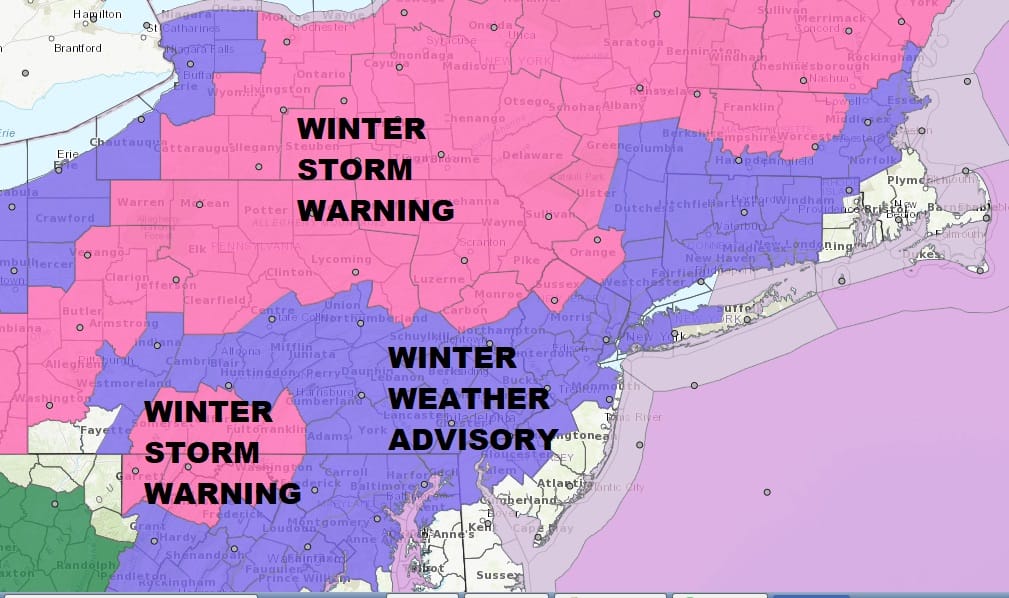
Precipitation is underway this morning and we have snow falling at the moment across Eastern Pennsylvania northeast to New Jersey to Long Island, Hudson Valley & Western Connecticut. Snow Freezing Rain moving northward will be the story today and then ultimately rain though how far north the rain/freezing rain line gets is anyone’s guess. Route 84 has been the battle ground road lately so we will shoot for a repeat of this today.
ICE ACCUMULATION FORECAST

SNOW ACCUMULATION FORECAST
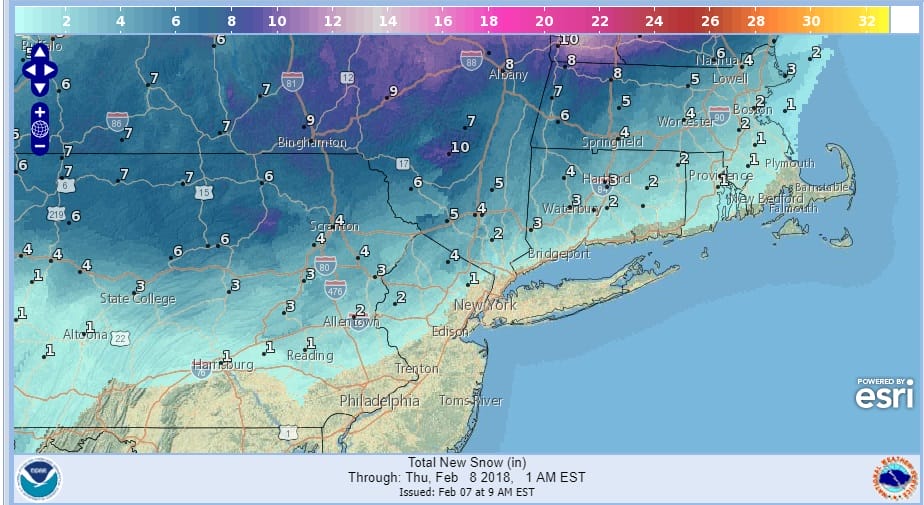
As far as snow accumulations are concerned a few inches in colder inland areas seems likely but snow will be minimal along the coast. Highest amounts of several to 6 inches will occur from Northwestern New Jersey to Northeast Pennsylvania north to the Catskills.
US SATELLITE

REGIONAL RADAR

Radar is loaded this morning with precipitation moving northward. The heaviest snows will be in the Winter Storm Warning areas with the highest amounts across Northern & Northeastern Pennsylvania northeast into the Catskills and up the middle and upper Hudson Valley.
LOCAL RADAR NEW YORK CITY

LOCAL RADAR PHILADELPHIA


The southern edge of this first round will play through coastal areas and then comes a lull as warm air begins to push northward. Then its a change to rain along the coast and several hours of freezing rain across Northern New Jersey the Hudson Valley into Connecticut. Temperatures are going to be critical all afternoon. Weather models often have a very difficult time with cold air that tends to dam southward from New England. Basically it will be a matter of watching thermometers inland hour by hour. Along the coast it is much easier as temperatures from Coastal Long Island to Central & South Jersey eventually rise into the 40s and even the 50s across South & Coastal New Jersey.
GFS TOTAL PRECIPITATION FORECAST

GFS total precipitation forecast in melted liquid is on the order of 3/4’s of an inch to an inch and a quarter. This all ends later this evening and then tonight as temperatures fall into the 20s, any standing moisture is likely to freeze up so be cautious for the Thursday morning commute. Thursday looks dry with some sunshine and highs in the 30s. Another weak system approaches on Friday with the chance for a period of light snow with highs in the 30s. Warmer temperatures and some rain is likely at some point over the weekend.
 GET JOE A CIGAR IF YOU LIKE

FiOS1 News Weather Forecast For Long Island
FiOS1 News Weather Forecast For New Jersey
FiOS1 News Weather Forecast For Hudson Valley


