
Snow Develops 2 to 5am Ends 8-11am Winter Weather Advisory
Snow Develops 2 to 5am Ends 8-11am Winter Weather Advisory
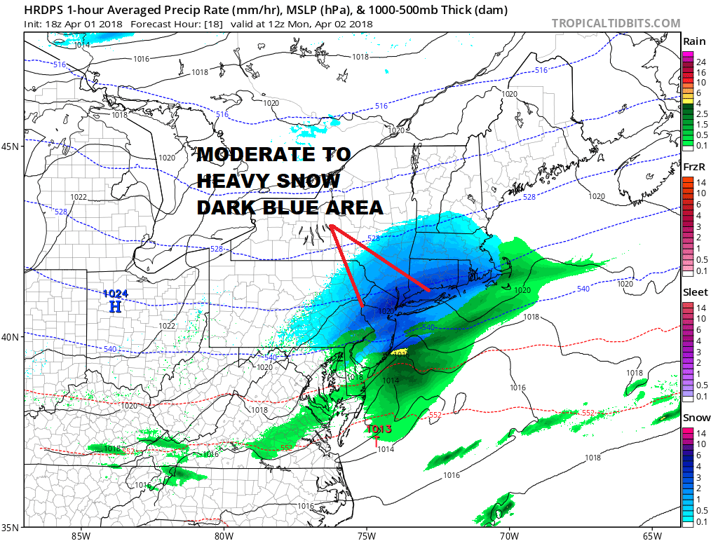
After what turned out to be a nice Easter Sunday afternoon across much of the region our attention shifts now to a fast moving wave of low pressure that is developing across the lower Ohio Valley. That wave is moving rapidly eastward. Clouds will be increasing tonight but there is nothing showing up on the radar anywhere close so there are no travel issues from now until the early morning hours. However after 2am snow will begin to break out across Pennsylvania and the spread to NYC New Jersey Hudson Valley Long Island and Connecticut by 5am .
US SATELLITE

REGIONAL RADAR

We can begin to see the radar echos entering the regional radar view from Ohio into Western Pennsylvania. By 2am the radar across Pennsylvania should be loaded up solidly.
LOCAL RADAR NEW YORK CITY

LOCAL RADAR PHILADELPHIA


With the Easter Passover holiday at least there will be a far less impact on the morning commute than on a normal Monday which is a good thing. It should be snowing hard between 6 and 9am in most areas. The short range models all seem to want to concentrate an area of moderate to heavy snow around NYC, Central & Northern New Jersey, Long Island, Southern Connecticut with lighter snows to the north.
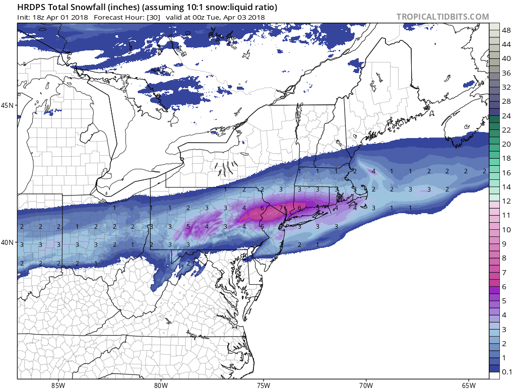
The snow forecast maps seem to want to concentrate heavy snows in slightly different areas but it seems to me that much the area should see a solid 3 to 6 inch snow fall. The high resolution RGEM model snow forecast has the belt of heavy snow just north and west and north and east of NYC.
HIGH RESOLUTION RGEM SNOW FORECAST
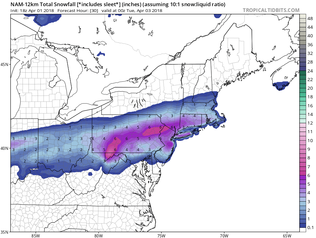
The NAM model has a the snow area a bit more spread out with amounts in the same ball park as the High Resolution RGEM but with the highest amount slightly less. To me I think the best approach is the general 3 to 6 inch idea and leave it at that.
NAM MODEL SNOW FORECAST
Either way the good news is that once it ends it will melt rather quickly. I’m not sure how paved surfaces are going to handle this. I would think that at least before 8am most surfaces will see some snow cover especially away from urban centers. Weather conditions will improve during the afternoon and you will be surprised as to how fast the snow disappears. There is no rest for the weary because the next storm system coming out of the Plains will be here on Tuesday with cloudy skies and rain developing in the morning. North and west of the coast we could see it start as a wintry mix. Then its a cold front and warm air on Wednesday with showers and maybe a thunderstorm with highs in the 60s. Then it calms down but it looks like we may have one more system to deal with next weekend with cold air and a chance for snow again.
 GET JOE A CIGAR IF YOU LIKE

FiOS1 News Weather Forecast For Long Island
FiOS1 News Weather Forecast For New Jersey
FiOS1 News Weather Forecast For Hudson Valley


