
Winter Weather Advisory Continues This Morning Snow 3 to 6 Inches
Winter Weather Advisory Continues This Morning
Snow 3 to 6 Inches
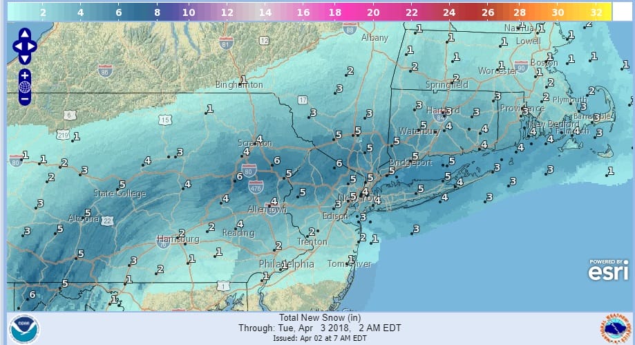
Snow is underway as advertised over the area with a heavy snow band setting up across Northern New Jersey into Southern Westchester and Long Island. A general 3 to 6 inch snowfall is forecast on cold surfaces and about 1/2 that on paved surfaces before this all ends before midday. Weather conditions improve this afternoon with clouds and some breaks of sunshine with temperatures rising into the lower 40s. The next storm system heads our way Tuesday with a chilly rain developing but north and west of the coast this could start off as a wintry mix. By Wednesday it is warm with showers and perhaps a thunderstorm with highs in the 60s. Then it is back down we go for a colder finish to the week.

GET JOE A CIGAR SO HE CAN RELAX!
NEW YORK CITY AND VICINITY SNOW

NEW YORK CITY & VICINITY ICE

NEW JERSEY SE PA & VICINITY ICE
NEW JERSEY & PARTS OF NE PA

SOUTHERN AND SOUTHEAST NEW ENGLAND

NORTHERN NEW ENGLAND

WESTERN NEW ENGLAND

MIDDLE AND UPPER HUDSON VALLEY

CENTRAL NEW YORK & NE PA

WESTERN NEW YORK

CENTRAL & SOUTH CENTRAL PA

VIRGINIA & MARYLAND

DAILY NORTHEAST SNOWFALL

Please be advised that these are National Weather Service Forecast Maps and they auto update. Each office may update at different times and some offices are slower to update then others. Maps are usually updated before 5am and & 5pm however they may be updated at other times depending on forecast conditions. These are not my forecasts. My forecasts can be found on the JOE’S SNOWFORECAST PAGE. Individual forecasts for specific areas may also be found when conditions warrant on the my area forecasts. Those can be found on the website menu. Click on forecasts and then select your specific area.