Snow Chances March 5-15 One More Window

Snow Chances March 5-15 One More Window
This winter no doubt has been frustrating to snow lovers and cold weather lovers. Cold air has been transient. We have seen 3 windows of opportunity that opened up in early December, January, & February before the pattern flipped to monster storminess in the Western US. I have been arguing there would be one more flip and one more window and long range models seem to be pointing to a brief period from about March 5th-15th where something may happen. Let me be clear that I am talking about chances for snow and not anything more specific than that. Also it would seem to me that the same areas that have seen snow this year which has been basically Northern New Jersey, Southeast NY, Long Island and areas north and east of there and I don’t see anything that changes that view. That means areas to the south down into the Middle Atlantic States, the chances appear slim.
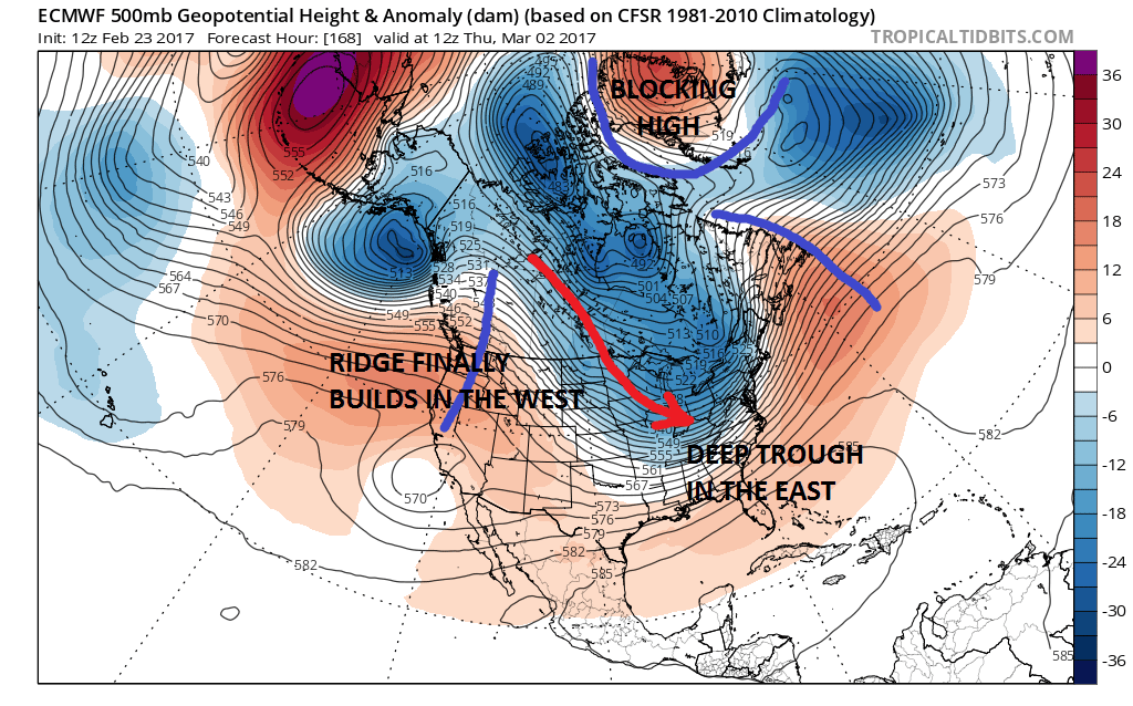
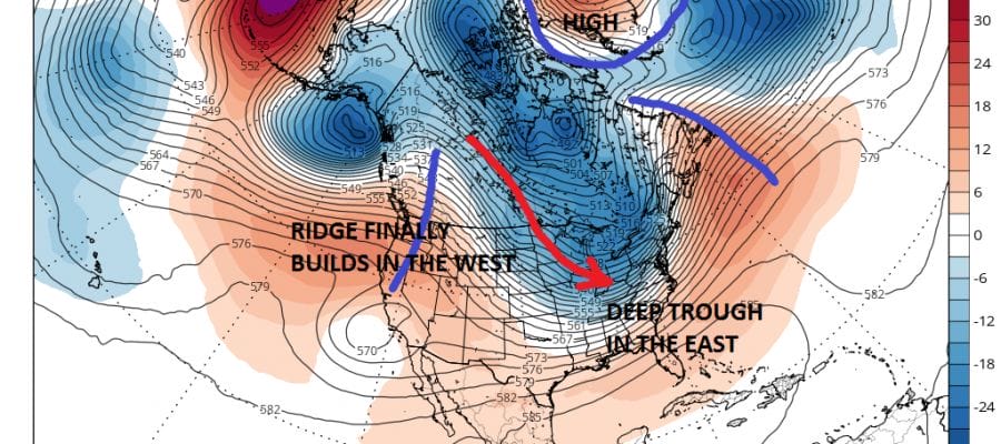
Both the European model and the GFS model show the development of a deep trough in the east and a building ridge in the west which is being anchored by a developing blocking high over Greenland. This to me suggests that there will be several systems that will dive southeastward in the flow from the northwest that will head to the northeast. I think the question will be whether the trough is deep enough and the systems strong enough to take tracks south of 40 degrees north. Or will the flow be less deep and we wind up seeing systems diving to the Great Lakes and moving across New England instead. That would mean nothing more than cold fronts will be moving through producing little or nothing of consequence.

The GFS seems a little more bullish on the idea, not that the European isn’t. Of course this is way too far out to speculate on anything other than there will be a short “window of opportunity”. Teleconnection indices seem to favor this idea. As for next week at least through Thursday temperatures will continue to be above average and there will be two weather systems in play that will bring rain. One late Monday into Tuesday and another late Wednesday into Thursday. After that we will see what happens. For now we watch.
MANY THANKS TO TROPICAL TIDBITS FOR THE WONDERFUL USE OF THE MAPS

GET JOE A CIGAR IF YOU LIKE!
SNOW REMOVAL COMPANIES FOR YOUR WINTER NEEDS
LONG ISLAND ROCKLAND COUNTY Connecticut

![]()

ROCKLAND COUNTY TRI STATE SNOW REMOVAL JOHNSTOWN PA


FiOS1 News Weather Forecast For Long Island
FiOS1 News Weather Forecast For New Jersey
FiOS1 News Weather Forecast For Hudson Valley
NATIONAL WEATHER SERVICE SNOW FORECASTS
LATEST JOESTRADAMUS ON THE LONG RANGE
Weather App

Don’t be without Meteorologist Joe Cioffi’s weather app. It is really a meteorologist app because you get my forecasts and my analysis and not some automated computer generated forecast based on the GFS model. This is why your app forecast changes every 6 hours. It is model driven with no human input at all. It gives you an icon, a temperature and no insight whatsoever.
It is a complete weather app to suit your forecast needs. All the weather information you need is right on your phone. Android or I-phone, use it to keep track of all the latest weather information and forecasts. This weather app is also free of advertising so you don’t have to worry about security issues with your device. An accurate forecast and no worries that your device is being compromised.
Use it in conjunction with my website and my facebook and twitter and you have complete weather coverage of all the latest weather and the long range outlook. The website has been redone and upgraded. Its easy to use and everything is archived so you can see how well Joe does or doesn’t do when it comes to forecasts and outlooks.
Just click on the google play button or the apple store button on the sidebar for my app which is on My Weather Concierge. Download the app for free. Subscribe to my forecasts on an ad free environment for just 99 cents a month.
Get my forecasts in the palm of your hand for less than the cost of a cup of Joe!
![]()
