
Snow Battles HRRR Model Vs Nam Model
Snow Battles HRRR Model Vs Nam Model
It is time for this mid March blizzard to get underway and we area seeing the powerhouse system organizing. The satellite loop this evening show the two distinct areas of energy involved here with the northern stream energy moving southeast across the Great Lakes and Ohio Valley and the second system in the southern stream which is absolutely loaded with tropical moisture which will gradually become 1 system overnight and intensify into a major storm when it reaches coastal Virginia in the morning.
SATELLITE LOOP

REGIONAL RADAR

Snow is on the regional radar is beginning to develop across Northern Virginia and it is moving northward. The rich tropical moisture and heavy rains are now moving out of North Carolina and into Virginia.
LOCAL RADAR NEW YORK CITY

LOCAL RADAR PHILADELPHIA


Snow will overspread the entire area over the next 6 hours and we will begin putting down accumulations. The big battle right now seems to be between the NAM model and the HRRR model which have similar tracks but the HRRR model has a much colder temperature profile of the atmosphere. This is critically important for coastal areas and their snow forecasts.
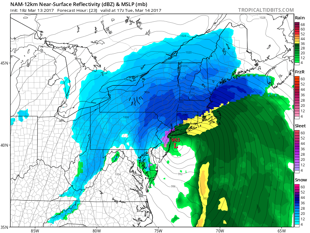
NAM MODEL ABOVE AND HRRR MODEL BELOW 1PM TUESDAY
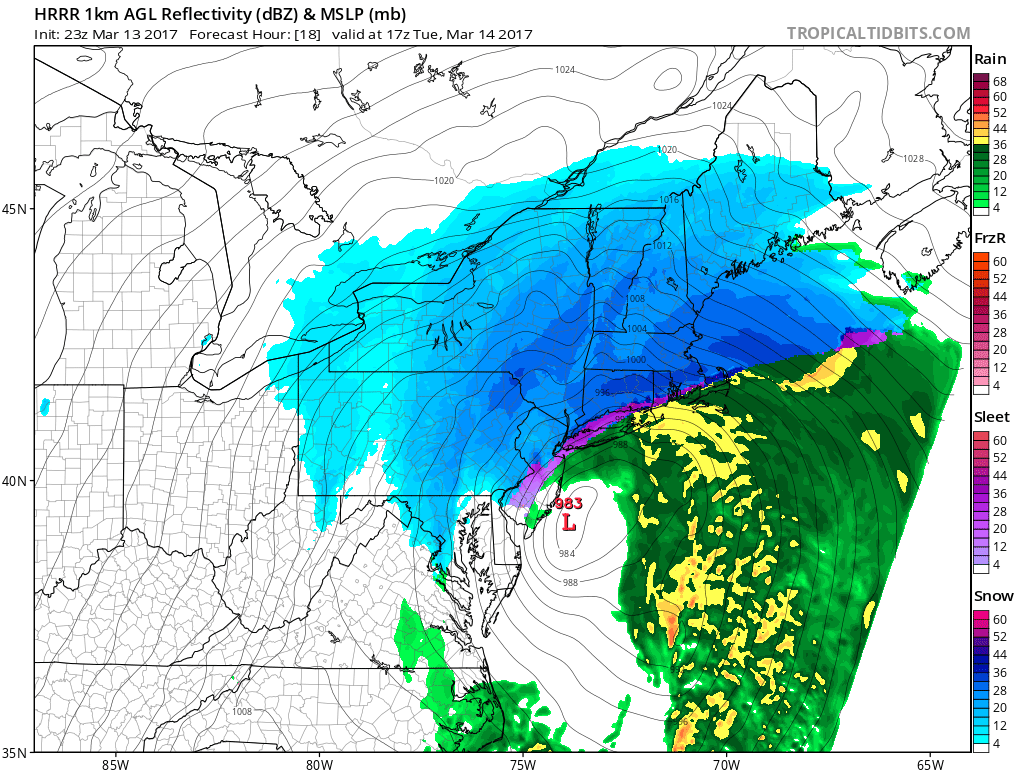
By early afternoon you can see where the sleet band is on the NAM vs the HRRR with the HRRR just a bit colder. But the NAM has it changing over at the coast at around 8am while the HRRR still has it snowing along the coast until noon.
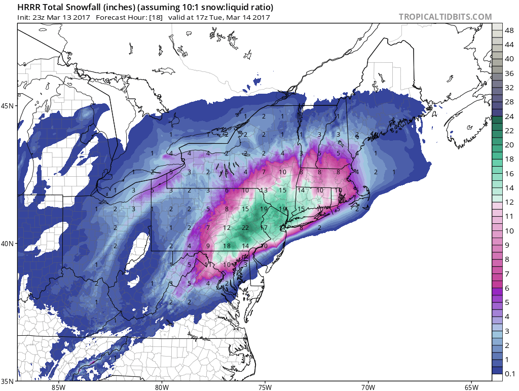
SNOW HRRR MODEL 5AM-1PM TUESDAY
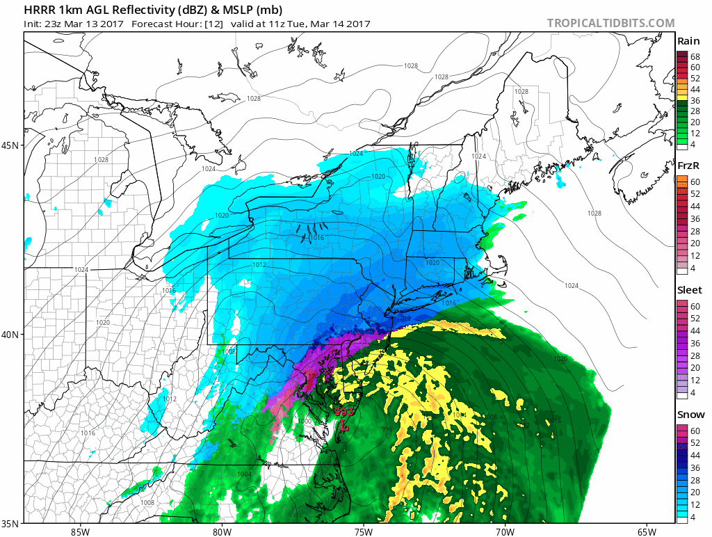
The HRRR snow forecast seems reasonable for areas from NYC north, northwest and northeast. The immediate coast is the big question.
The other big issue will be the wind and winds along the coast will gust to 50-60 mph Monday as the storm center moves by just to the east of New Jersey and South of Long Island.
 GET JOE A CIGAR IF YOU LIKE

SNOW REMOVAL COMPANIES FOR YOUR WINTER NEEDS
LONG ISLAND ROCKLAND COUNTY Connecticut

![]()

ROCKLAND COUNTY TRI STATE SNOW REMOVAL JOHNSTOWN PA


FiOS1 News Weather Forecast For Long Island
FiOS1 News Weather Forecast For New Jersey
FiOS1 News Weather Forecast For Hudson Valley
NATIONAL WEATHER SERVICE SNOW FORECASTS
LATEST JOESTRADAMUS ON THE LONG RANGE
Weather App

Don’t be without Meteorologist Joe Cioffi’s weather app. It is really a meteorologist app because you get my forecasts and my analysis and not some automated computer generated forecast based on the GFS model. This is why your app forecast changes every 6 hours. It is model driven with no human input at all. It gives you an icon, a temperature and no insight whatsoever.
It is a complete weather app to suit your forecast needs. All the weather information you need is right on your phone. Android or I-phone, use it to keep track of all the latest weather information and forecasts. This weather app is also free of advertising so you don’t have to worry about security issues with your device. An accurate forecast and no worries that your device is being compromised.
Use it in conjunction with my website and my facebook and twitter and you have complete weather coverage of all the latest weather and the long range outlook. The website has been redone and upgraded. Its easy to use and everything is archived so you can see how well Joe does or doesn’t do when it comes to forecasts and outlooks.
Just click on the google play button or the apple store button on the sidebar for my app which is on My Weather Concierge. Download the app for free. Subscribe to my forecasts on an ad free environment for just 99 cents a month.
Get my forecasts in the palm of your hand for less than the cost of a cup of Joe!


