Showers Today Much Colder Wednesday Through Friday
Snow Chance Grows For Southeast US
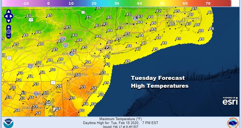
Today it is all about a weak cold front and low pressure moving across Upstate NY and New England. There really isn’t much to this system. It is on the weak side and we are seeing moisture streaming northeastward. It is a raw Tuesday with temperatures that will be struggling higher. It may take all day for milder air to make it north of NYC & Philadelphia with a stubborn warm front to the south and a cold front to the west.
SATELLITE

REGIONAL RADAR

Regional radar shows an area of snow moving across Upstate NY and heading for Northern New England. On the southern flank of this is precipitation that is very light and mostly aloft. There is a higher chance for rain later today into tonight as the cold front gets closer.
LOCAL RADAR NEW YORK CITY

LOCAL RADAR PHILADELPHIA


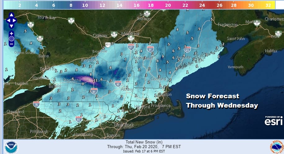
There are no changes in the rain and snow amounts that are being forecast for the Northeast and Northern Mid Atlantic states. Snow is generally north of I-90 in upstate NY and New England and tails off south of there rather quickly.
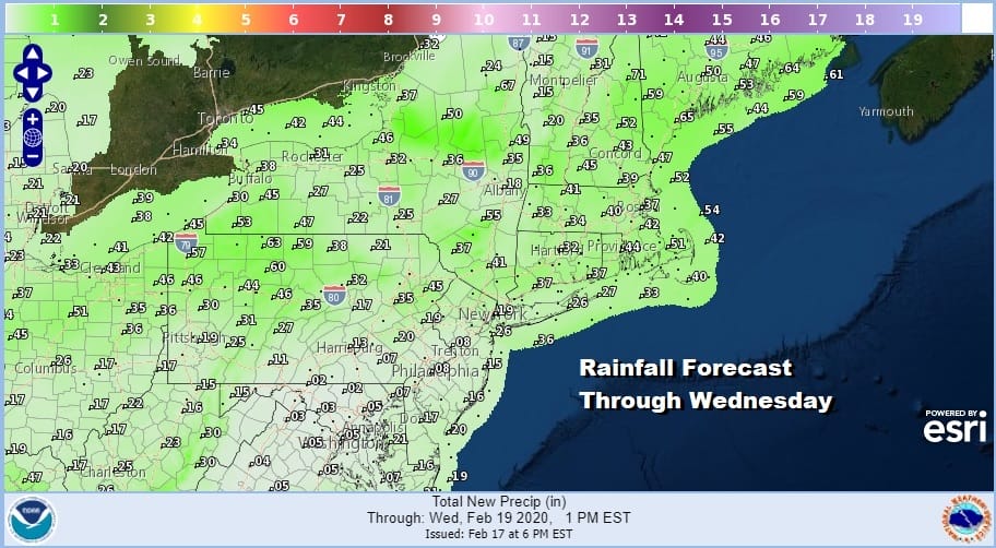
Rainfall amounts also are nothing to shout home about as they will be generally a quarter of an inch or less along the I-95 urban corridor. Higher amounts will occur well to the west and north closer to the low track.
Once the rain pulls out weather conditions will improve for the rest of the week and we see no rain or snow in the forecast for the Northeast and Northern Mid Atlantic states possibly right through this coming weekend. However it will be cold starting Wednesday as cold air arrives. We will still be in the low to mid 40s for highs before temperatures sink down into the teens to low 20s Thursday morning.

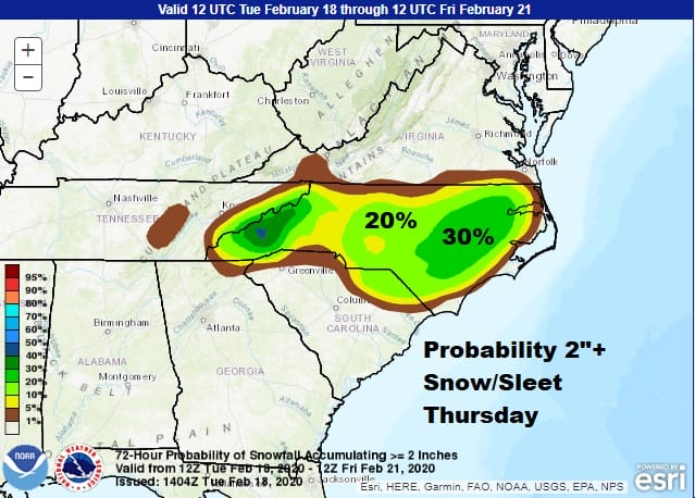
Thursday we will see some sunshine but it will be a cold day with highs just in the 30s. Some high clouds could reach us from low pressure that will developing off the Southeast coast of the US. Cold air will be bleeding southward all the way to Georgia and it sets up for possibly some accumulating snow from Northeast Georgia northeastward into Southern Virginia including most of North Carolina and part of South Carolina. Much will depend on the robust nature of the wave.
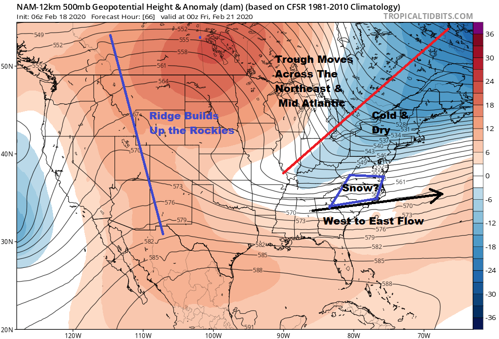
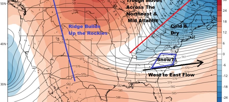
We finally have cold air that matters for snow lovers but now the problem is in the other direction. Cold dry air overwhelms the Northeast and Middle Atlantic states and in fact much of the US leaving a west to east flow and a flat-ish wave moving across the Southern states. The upper flow now is completely unfavorable for a low to move up the East Coast. This is primarily for areas from Southern Virginia southward.

The NAM model today is the most robust but even the GFS and others are coming around to this idea. The Weather Prediction Center has upped the odds of accumulating snows for the Southeast US on Thursday.
Once this weather system moves out on Friday it leaves the Eastern US dry through the weekend. Friday will be another cold but sunny day here in our neck of the woods with morning lows in the teens and low 20s with single digits in cold spots and highs reaching the 30s. Temperatures will bounce higher for the weekend into the 40s on Saturday and 50s possible on Sunday. After today the next chance for any precipitation (probably mostly rain) will be later Monday into Tuesday of next week so at least we have a dry stretch of 5 to 6 days ahead of us.
BE SURE TO DOWNLOAD THE FREE METEOROLOGIST JOE CIOFFI WEATHER APP &
ANGRY BEN’S FREE WEATHER APP “THE ANGRY WEATHERMAN!
MANY THANKS TO TROPICAL TIDBITS FOR THE USE OF MAPS
Please note that with regards to any severe weather, tropical storms, or hurricanes, should a storm be threatening, please consult your local National Weather Service office or your local government officials about what action you should be taking to protect life and property.


