Showers End Overnight Cold Dry Wednesday Through Friday
Snow Carolinas Southern Virginia Stays South
We still have some more work to do regarding showers tonight as we are waiting for this cold front to go by. Actually a warm front may try and pass through first giving temperatures a nudge up before the cold front moves offshore and weather conditions start to genuinely improve. That won’t happen until the early morning hours so look for clouds and the chance for showers until then. Temperatures will likely spend much of their time in the 40s overnight.
SATELLITE

REGIONAL RADAR

Regional and local radars are still picking up patches of showers moving across Pennsylvania southward into Virginia. We are seeing rain as far north as I-90 in NY State as we wait for a change over to snow overnight up north into Thursday morning as the low goes by to our north. Local radars are picking up on showers this evening but not everyone is participating.
LOCAL RADAR NEW YORK CITY

LOCAL RADAR PHILADELPHIA


Wednesday begins what should be a 5 day stretch of dry weather conditions though the first 3 of those will be cold especially Thursday and Friday. Some sunshine should return Wednesday with temperatures mostly in the low to mid 40s and then we head down to the teens and low 20s Thursday morning.

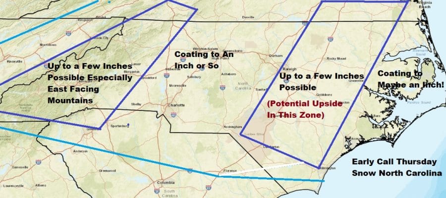
Thursday will be a rather cold day with sunshine through high clouds. Those high clouds will be coming from the old stalled frontal boundary off the Southeast Coast and a wave of low pressure that develops on it. This will bring accumulating snows to the Southern Mid Atlantic states especially North Carolina.

Since we have no use for snow forecast maps around here these days, here is an early call on the snow for North Carolina where I think the “brunt” of this will be. There is room for some upside here if the wave is more robust in nature as some models indicate.
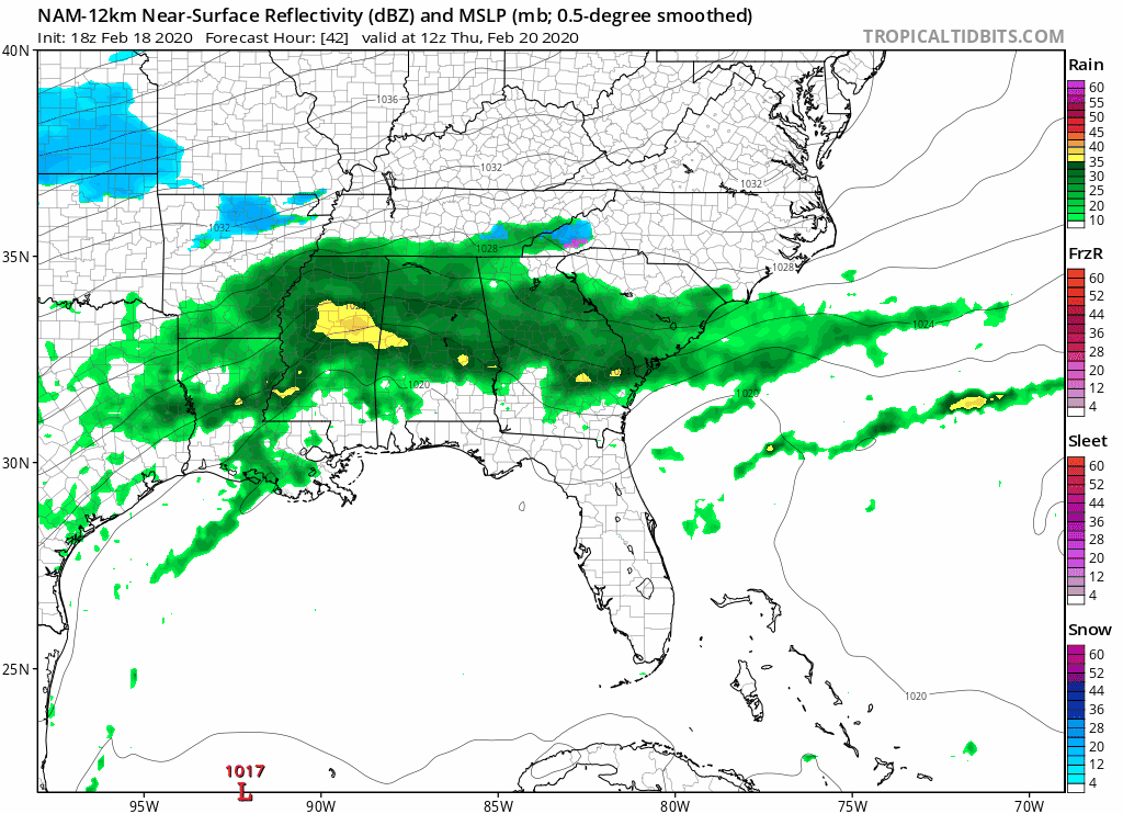
Models move this along Thursday and Thursday night and it will be offshore on Friday. This actually helps to hold in very cold air for an extra day for us. Look for sunshine on Friday with highs just into the 30s. After that the weather warms up over the weekend. We will be back into the 40s on Saturday with some sunshine and in the upper 40s to middle 50s on Sunday with some sunshine. After tonight the next chance for any rain won’t come until next Monday.
BE SURE TO DOWNLOAD THE FREE METEOROLOGIST JOE CIOFFI WEATHER APP &
ANGRY BEN’S FREE WEATHER APP “THE ANGRY WEATHERMAN!
MANY THANKS TO TROPICAL TIDBITS FOR THE USE OF MAPS
Please note that with regards to any severe weather, tropical storms, or hurricanes, should a storm be threatening, please consult your local National Weather Service office or your local government officials about what action you should be taking to protect life and property.


