Showers Overnight Colder Into Saturday Snow Rain At Night
Showers Overnight Colder Into Saturday Snow Rain At Night
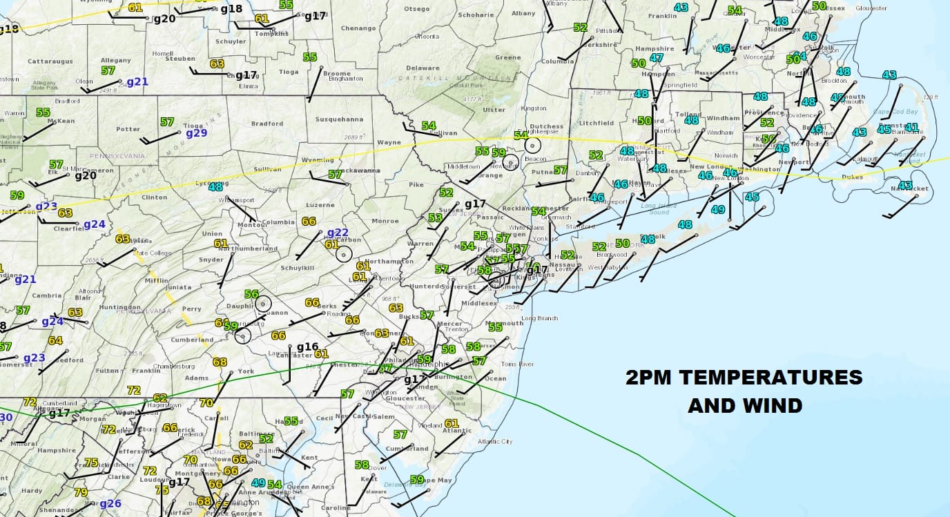
Clouds have been a big issue today as they have held temperatures down across New Jersey into Southern New England. Temperatures have been mostly in the 50s through 2pm. 60s are in Pennsylvania and we have 70s in Northeast Virginia. The satellite view shows the stubborn clouds over the area and unless we get a last minute break out of sunshine, temperatures will probably not change much from here.
US SATELLITE

REGIONAL RADAR

Other than a shower or two in Delaware Bay the radars are quiet. Showers from the cold front that will be approaching tonight and Friday morning are coming into view to the west but they won’t get here until late this evening or possibly after midnight. Temperatures will probably hold in the 40s and 50s with the cooler temperatures over south facing shorelines.
LOCAL RADAR NEW YORK CITY

LOCAL RADAR PHILADELPHIA


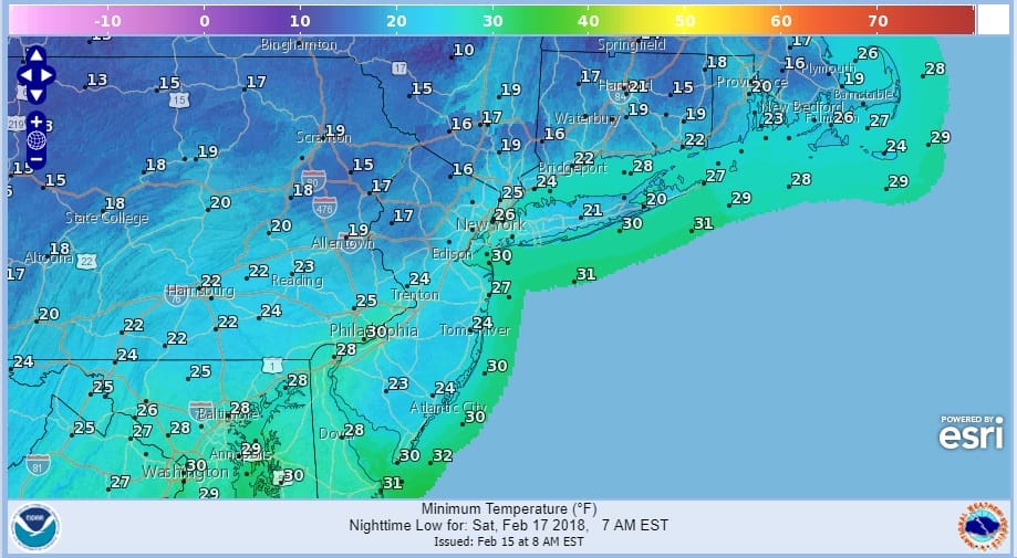
Showers will be moving out Friday morning and weather conditions will improve Friday afternoon as temperatures ease into the 40s by days end. By Saturday morning as the next shot of cold air comes in, temperatures will be in the teens to low 20s in most places.
SATURDAY MORNING FORECAST LOW TEMPERATURES
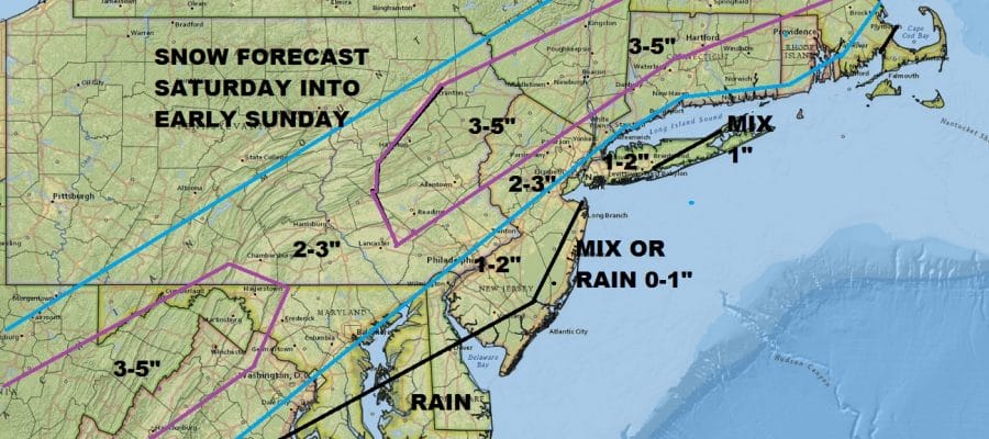
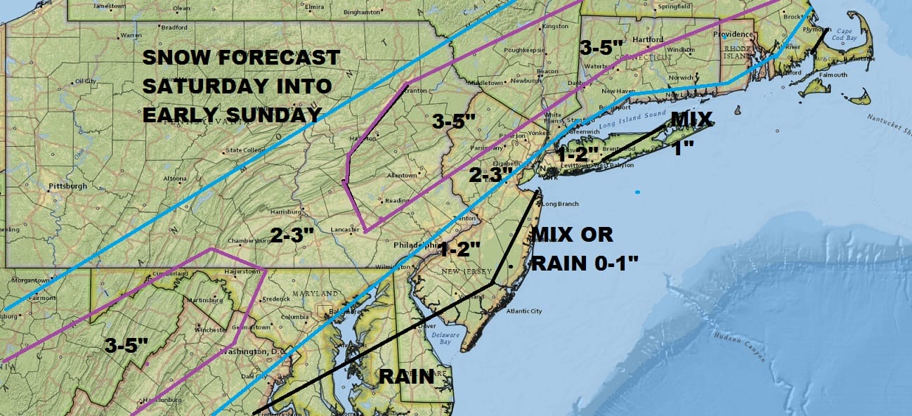
Saturday day side will not be too bad with sunshine giving way to arriving clouds. In areas north of NYC the clouds may not come in until early to mid afternoon. Temperatures will be in the 30s to near 40. Then snow/mix/rain develops Saturday evening. Inland areas start as snow. Coastal areas in New Jersey start as a mix or just rain. The bulk of the snow falls at night. Right now the highest accumulations will be in New Jersey north of Route 78, the Hudson Valley north of 287 and in Connecticut north of 95. A general 2 to 5 inch snow fall is likely in areas where it is all snow with a slushy 2 inches or less to the south of this area. Some coastal areas could see very little. Temperatures are borderline here so a 1 degree shift may change this accumulation profile somewhat.
JOE’S SNOW FORECAST MAP
This will be long gone by Sunday daybreak so this is a quick overnight hit. There really isn’t any cold air to speak of behind this so this snowfall will melt rather quickly. Look for some sunshine on Sunday with highs reaching the 40s by afternoon. Monday through Wednesday will be warmer and we will be in the 50s Monday and the 60S Tuesday and Wednesday with more showers coming as we head into midweek.
 GET JOE A CIGAR IF YOU LIKE

FiOS1 News Weather Forecast For Long Island
FiOS1 News Weather Forecast For New Jersey
FiOS1 News Weather Forecast For Hudson Valley