HOT HUMID WEATHER ONE MORE DAY
SEVERE WEATHER RISK THURSDAY EVENING
COOLER FRIDAY WEEKEND BUT CLOUD & SHOWER ISSUES
Another day of heat and humidity with temperatures in the upper 80s to lower 90s, dew points in the 70s, and heat indices between 95 & 100. It is another day in this Florida like tropical air mass but without the pop up thunderstorms. Satellite and radar shows them to be few and far between and virtually non existent over us. Tonight is another very warm tropical night with temperatures in the 70s.
EASTERN SATELLITE

REGIONAL RADAR

Thursday will finally be the last day of this hot stretch of weather. We will see clouds and some sun hot humid conditions on Thursday with highs reaching into the 90s. A cold front approaches with thunderstorms late in the afternoon and evening. The Storm Prediction Center has us at risk for severe weather so bear that in mind if you have late day or evening plans.
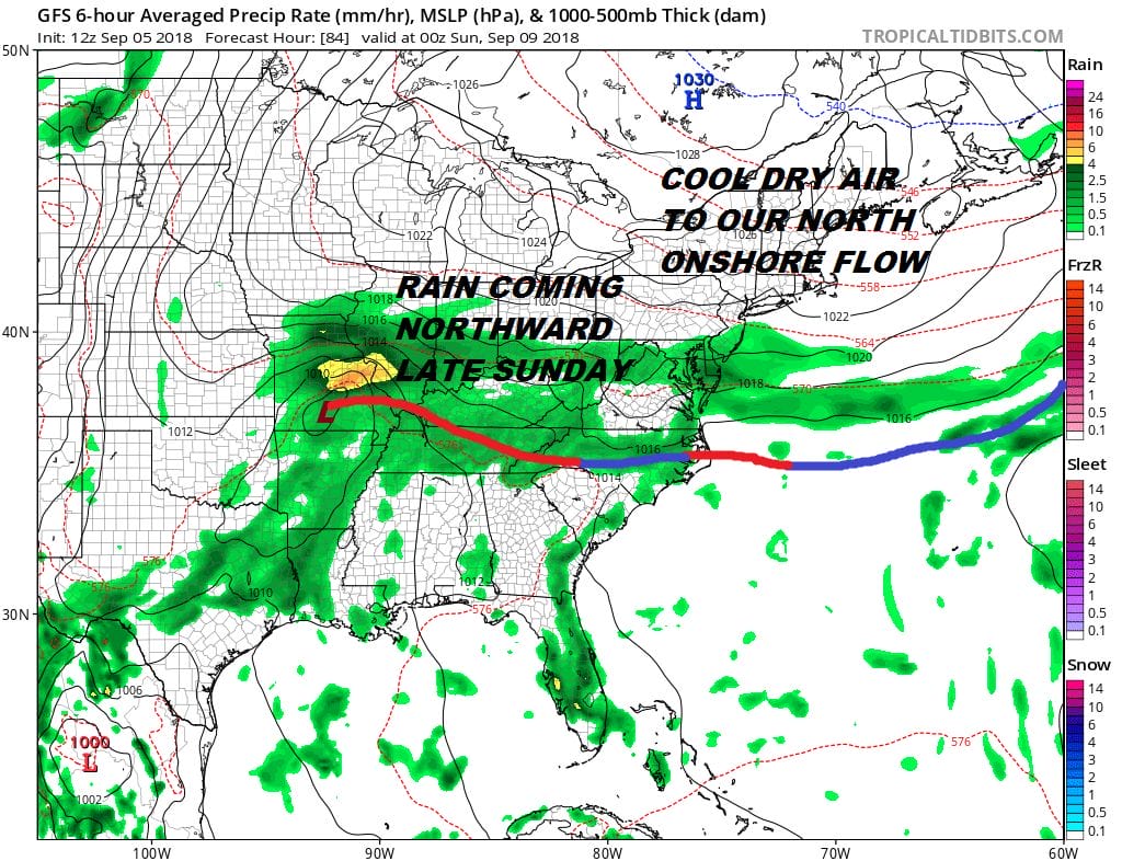
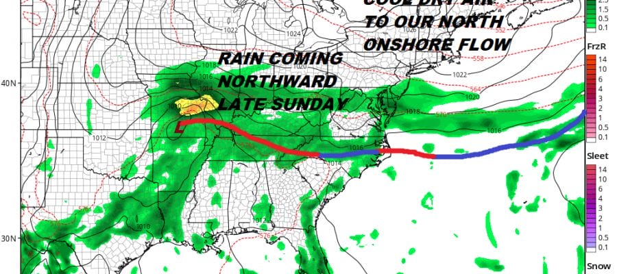
The front will slow down to our south on Friday which will likely keep us in lots of clouds. A developing ocean wind probably keeps temperatures in the 70s to near 80. Some passing showers can’t be ruled out. Saturday the high to the north tries to press southward with limited success. This could be a situation where areas to the north and east of NYC see a few breaks of sun while South Jersey & Southeastern Pennsylvania sit in clouds all day. Temperatures will be in the 70s. Humdity levels will be lower as you go north.
Sunday we start to see the front moving back northward. The dry air mass to the north will try and hold showers back and that could keep rain out of most of the area until Sunday night. Sunday’s highs will just be in the low to mid 70s in most places. We will have rain and downpours Sunday night into Monday morning until the warm front passes. Then it will be a trip back to warm humid conditions Tuesday and beyond.
Hurricane Florence is now a category 4 hurricane with winds of 130 mph as of the 5pm advisory. With regards to Hurricane Florence and whether it becomes a factor in the weather along the East Coast later next week it is way to early to speculate on that but we can at least look at the issues involved and JOESTRADAMUS has more on this.
MANY THANKS TO TROPICAL TIDBITS FOR THE USE OF MAPS
Please note that with regards to any tropical storms or hurricanes, should a storm be threatening, please consult your local National Weather Service office or your local government officials about what action you should be taking to protect life and property.
LATEST JOESTRADAMUS ON THE LONG RANGE


