Severe Weather Threat Friday Nice Weekend Ahead
Severe Weather Threat Friday Nice Weekend Ahead
Yesterday’s rain is now all done and gone and we are seeing the jet stream moving again. There is still some housecleaning to do however as we still have clouds around this morning on the satellite view. There should at least be more in the way of sunshine and a bit less in cloud cover today. That will boost temperatures to the middle and upper 80s. Since it is still rather humid and we have a lot of tropical air around, we will have to watch for the possibility of a downpour or thunderstorm popping up. Given that the ground is saturated in most places, a heavier thunderstorm could create some localized flooding.
EASTERN SATELLITE

REGIONAL RADAR

Radars this morning are showing some scattered showers mostly offshore and to the north and east. Look for some downpours to pop up in scattered locations later today.
LOCAL RADAR NEW YORK CITY

LOCAL RADAR PHILADELPHIA


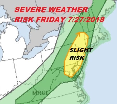
Friday brings a more important change as a weather front/dry line approaches. There will be enough instability to create a threat for severe weather late in the Friday and the Storm Prediction Center has our area at a slight risk for severe weather. Sunshine will start the day Friday before we see some downpours and thunderstorms developing during the afternoon and evening. Temperatures will be in the 80s to near 90.
The good news is the weekend where we will see at least some sunshine both Saturday and Sunday, lower humidity, and warm temperatures in the 80s. It appears we will have 2 days with no rain threats which is great and the slightly lower humidity will make things more bearable.
 GET JOE A CIGAR IF YOU LIKE

FiOS1 News Weather Forecast For Long Island
FiOS1 News Weather Forecast For New Jersey
FiOS1 News Weather Forecast For Hudson Valley
NATIONAL WEATHER SERVICE SNOW FORECASTS
LATEST JOESTRADAMUS ON THE LONG RANGE


