Low Moving Northward Downpours Thunderstorms Early Tonight
Low Moving Northward Downpours Thunderstorms Early Tonight Flash Flood Watch Continues New Jersey

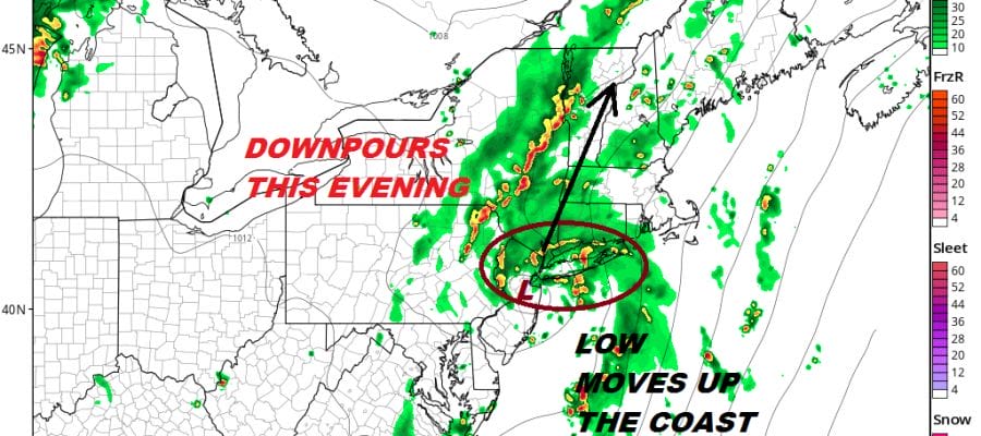
As we head into the evening rush hour commute and the first part of tonight we are seeing a gradual increase in downpours on the radar though there are areas that are not getting much at the moment. The main thrust of downpours and thunderstorms will likely come between 8pm and midnight as a low pressure area that formed this morning near Eastern North Carolina moves northward. In a way this is like the system we saw on Saturday though it is not nearly as widespread in terms of the impact. However there will likely be some strong thunderstorms and heavy downpours that form near and to the north of the low center as it moves northward just inland of the New Jersey coast and passes close to NYC & Long Island. The dynamics are here for an isolated severe thunderstorm or two to develop so we will be watching closely.
EASTERN SATELLITE

REGIONAL RADAR

The satellite and radar loops continue to show bands of downpours revving up to the south so there will be some rain impacting the evening commute. be advised that if any downpours wind up sitting of a particular area for a period of time it will likely trigger off some flooding issues so the flash flood watch continues into tonight.
LOCAL RADAR NEW YORK CITY

LOCAL RADAR PHILADELPHIA


The upper trough to the west is finally lifting out to the northeast which should lead to a better day on Thursday with clouds and some sunshine with the chance for some scattered afternoon or evening thunderstorms. Highs Thursday will be well up into the 80s to near 90 in some spots.
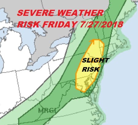
We are still thinking that we could see some severe weather here late Friday as a trough/front marking the leading edge of slightly drier air pushes east and triggers off thunderstorms Friday afternoon and evening. The weekend is looking promising with sunshine and some clouds but slightly lower humidity and a very low chance if any of showers and thunderstorms.
Please note that with regards to any tropical storms or hurricanes, should a storm be threatening, please consult your local National Weather Service office or your local government officials about what action you should be taking to protect life and property.
 GET JOE A CIGAR IF YOU LIKE

LATEST JOESTRADAMUS ON THE LONG RANGE


