
Severe Weather Risk Before Humidity Temperatures Nosedive This Weekend
Perhaps the word “nosedives” overstates the weather change somewhat but it is going to be a significant drop in temperatures and humidity. We will be going to highs in the upper 80s to lower 90s to highs in the low to mid 70s in many locations. I think that is rather significant. More importantly the humidity drops off substantially and that is going to make things very nice around here. First things first is one last day of heat and humidity today as we will have sunshine with highs reaching the upper 80s and lower 90s.
SATELLITE

REGIONAL RADAR

Daytime heating is underway and we are going to be watching radars closely late this afternoon and this evening with the chance for thunderstorms developing. The next cold front is on the move and it will get here tonight into Friday morning. Not much is happening on the regional and local radars and I don’t expect much to happen until after 3 or 4pm.
LOCAL RADAR NEW YORK CITY

LOCAL RADAR PHILADELPHIA 

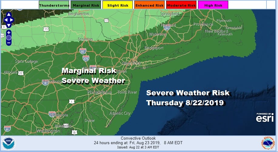
I wasn’t overly impressed with the severe weather set up for today.in terms of seeing a widespread outbreak I tend to think that severe thunderstorms will be more isolated in nature inside a broader area of thunderstorms that could develop. Also the front gets hung up a bit and it may not get completely through here until Friday morning. This leaves the risk for downpours or thunderstorms into daybreak Friday. The Storm Prediction Center has much of our area at a marginal risk for severe weather.
We are going to start Friday with lots of clouds and those leftover morning showers mainly along the coast but we will see gradual improvement as the day wears on with decreasing clouds and increasing sun Friday afternoon. Temperatures Friday will be just in the upper 70s to lower 80s as that cooler air from the Great Lakes arrives. The humidity takes a nosedive and sets us up for the weekend.
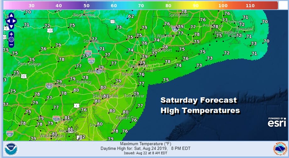
Saturday is going to be a beautiful day with lots of sunshine and look at those daytime highs! Highs will only be in the 70s to at most 80 in the warmest spots. Humidity levels will be very low and there will be a nice northeast breeze. It will feel absolutely terrific out there with nothing more than a few passing clouds. Sunday brings some minor issues as we combine an onshore flow with the high passing to our northeast and a frontal boundary to our south.

There is going to be a weak upper trough overhead and that could produce some patchy clouds and even a spot shower can’t be ruled out. Otherwise I think Sunday is no worse than a mix of sun and clouds with highs mostly in the low to mid 70s! Humidity levels will still be on the low side. Monday brings sunshine giving way to arriving clouds as a warm front approaches from the south and we get ready for the next frontal system. Highs Monday will be in the 70s. We could see some downpours Monday night into Tuesday as the warm front goes by and the a cold front follows for midweek.
MANY THANKS TO TROPICAL TIDBITS FOR THE USE OF MAPS
Please note that with regards to any tropical storms or hurricanes, should a storm be threatening, please consult your local National Weather Service office or your local government officials about what action you should be taking to protect life and property.


