Sally Rains Moving Northeast Glancing New Jersey Long Island
Autumn Weather Cool Friday Through Monday
Joe & Joe Weather Show Podcast
Clouds rolled in all day and now we are seeing a cold front that is advancing from the west while the remnant low of Hurricane Sally is moving northeastward. Rain has spread across the Mid Atlantic states and is now in range of our local radars below. However the front should push this rain to the east over night. While Southern New Jersey and perhaps Long Island get into some of this rain overnight, it should be moving away to the east by daybreak. Temperatures overnight will hold in the 60s thanks to all the cloud cover. Inland areas might see a passing shower overnight but nothing more.
SATELLITE
REGIONAL RADAR
A rather large area of rain is covering the Carolinas and Virginia with the northern edge into Southern New Jersey this evening. This rain area will move northeast and we will watch the northern edge pivot around and begin to slide eastward overnight. Rainfall amounts if any will be under a tenth of an inch while areas to the south from Southern New Jersey southward will get a bit more.
LOCAL RADAR NEW YORK CITY
LOCAL RADAR PHILADELPHIA

Friday we will see cool air arriving on the back side of this weather front and high pressure will start to build in from the Great Lakes. This is a very cool high and it will be with us in one form or another right into the start of next week. Look for decreasing clouds on Friday with some sunshine developing from northwest to southeast during the afternoon. A gusty breeze will develop and temperatures will hold in the 60s.
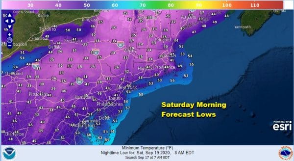
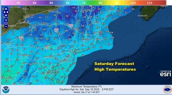
Autumn arrives on Tuesday however this weekend autumn weather will take hold. Saturday morning lows will be in the 40s except for lower 50s over warmer urban settings and along the coast. We will see lots of sunshine Saturday with highs just in the 60s.
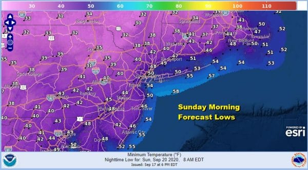
Saturday night will be nice and clear and it will be another rather chilly night. Sunday morning lows will be in the 40s to around 50 and northern areas in Pennsylvania and the Hudson Valley will see their first 30s since back late last spring. Those cold spots might even see some frosts and freezes out of this.
Sunday we will have lots of sunshine with highs again just in the 60s and some areas inland might have a tough time getting above the 60 degree mark. Down we go again Sunday night and then Monday more of the same with sunshine and highs in the 60s.
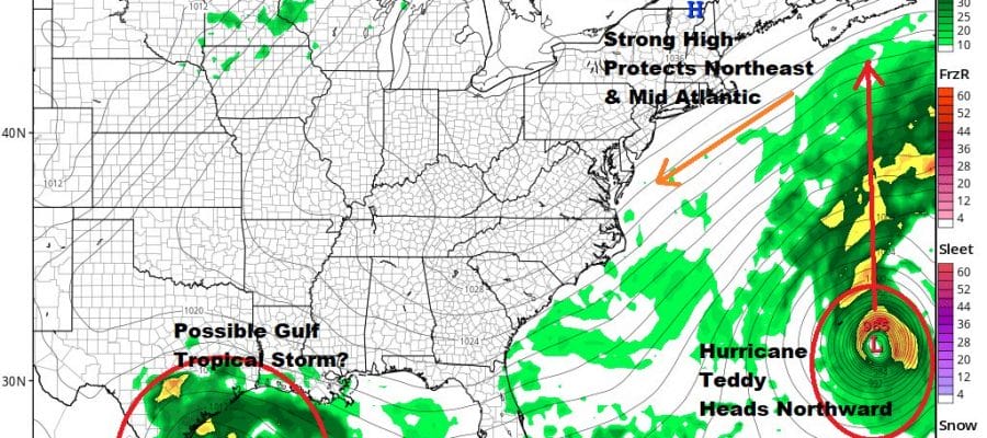
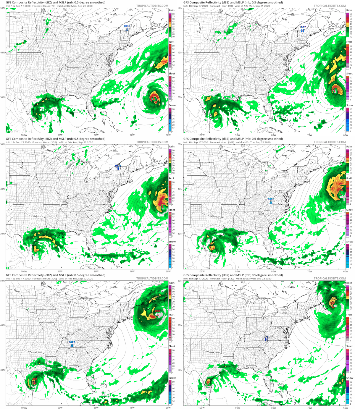
Next week it seems we will be in a sweet spot Monday through Wednesday thanks to the large high in Northern New England that will eventually find its way into the Middle Atlantic States. This strong high is going to keep our weather cool. To the southeast we see Hurricane Teddy. To the southwest we have what could be another tropical storm in the Gulf of Mexico. Teddy will be forced northward up the coast and well offshore our area. However it will be kicking up the surf next week. Monday into Tuesday could turn out to be on the breezy side with Teddy going by to the east of us by about 600 miles. However it seems that after coming close to Bermuda Sunday night into Monday, Teddy could be making a run for Nova Scotia on Tuesday as a very formidable hurricane. There is still some model uncertainty with this as far as exact track and timing but we can say that Teddy will pass well to the east of us. In fact the track of Teddy ultimately brings more dry air into the Eastern US and we may go all of next week without a drop of rain.
BE SURE TO DOWNLOAD THE FREE METEOROLOGIST JOE CIOFFI WEATHER APP &
ANGRY BEN’S FREE WEATHER APP “THE ANGRY WEATHERMAN!
MANY THANKS TO TROPICAL TIDBITS FOR THE USE OF MAPS
Please note that with regards to any severe weather, tropical storms, or hurricanes, should a storm be threatening, please consult your local National Weather Service office or your local government officials about what action you should be taking to protect life and property.

