Last Days of Summer Feel Like Autumn Hurricane Teddy Tropical Depression 22
WEATHER IN 5 PODCAST
Just like that we have come to the end of summer. Autumn doesn’t arrive until Tuesday September 22, but the weather this weekend says autumn all over it. It begins today now that a cold front has passed and rain from the remnants of Hurricane Sally have moved offshore. Today we will spend the day with slowly decreasing clouds from northwest to southeast, and slowly increasing sunshine especially during this afternoon. Very cool air from high pressure in the Great Lakes will keep temperatures today mostly in the 60s setting us up for a very cool night ahead.
SATELLITE
REGIONAL RADAR
The satellite shows skies beginning to clear out across Upstate NY and the radar shows rain from last night offshore back into Southeast Virginia moving eastward. Radars are going to be shut down for the next 7 days given the dry pattern we will be in.
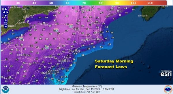
Skies will be clear tonight and it will also turn rather cool by morning. It actually will be cold enough to set off frost advisories and freeze watches in Upstate NY and there will be more of those over a wider area for Saturday night into Sunday morning. Our Saturday morning lows will be in the 40s in many locations and only the warmer urban centers and the coast will stay above 50.
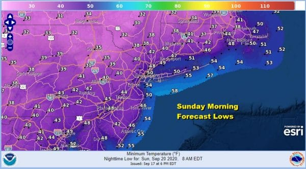
Both Saturday and Sunday will be very cool with sunshine both days along with a bit of a breeze especially along the coast. Highs will be in the low to mid 60s both days. In fact areas to the northwest of the coast like the Hudson Valley and Northeastern Pennsylvania up into New England may have a tough time getting above 60 both days. Then it is down again to the 40s Sunday and Monday morning with 30s in many cold spots.
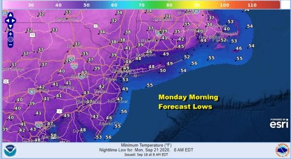
Monday morning will be the coldest morning of this stretch of weather and the 30s will be pushing down further south and east by Monday morning. There could be widespread frosts and freezes Monday morning well inland.
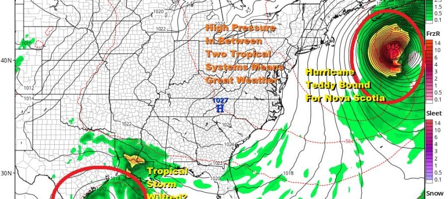
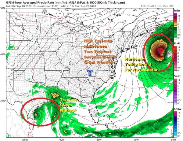
Monday will be another day of lots of sunshine with highs just in the 60s. High pressure over New England will eventually migrate to the Mid Atlantic states Tuesday and Wednesday and this is in response to Hurricane Teddy. Teddy will make a close pass to Bermuda Sunday night into Monday and pass just far enough east to spare the island major issues. However it will be very close. After that Hurricane Teddy will accelerate northward and the risk for a landfall of a hurricane in Nova Scotia grows.
With Teddy well offshore its interaction with the strong high will create a long fetch of northeast winds from Southern New England southward to the Mid Atlantic states this weekend and Monday. This puts the area at risk for coastal flooding at high tide starting today and through the weekend. We just had a new moon yesterday and with the Autumnal equinox Tuesday tides will be running higher than normal.
Meanwhile Tropical Depression 22 is in the Southwest Gulf of Mexico and it is likely to become a tropical storm later today as it gets better organized. This storm will meander in the Western Gulf over the weekend and for much of this coming week possibly bringing big rain issues to the Texas and Louisiana coasts. With tropical systems on opposite ends, one northeast and one well southwest, we are stuck in the land of high pressure all of next week. That means we have sunshine much of the time. Temperatures will still be in the 60s to near 70 Tuesday and perhaps get back into the 70s for next Wednesday and Thursday. No rain is indicated for the next 7 days. Any important widespread rain may have to wait toward the end of the month when the upper air pattern will begin to shift around in an important way.
BE SURE TO DOWNLOAD THE FREE METEOROLOGIST JOE CIOFFI WEATHER APP &
ANGRY BEN’S FREE WEATHER APP “THE ANGRY WEATHERMAN!
MANY THANKS TO TROPICAL TIDBITS FOR THE USE OF MAPS
Please note that with regards to any severe weather, tropical storms, or hurricanes, should a storm be threatening, please consult your local National Weather Service office or your local government officials about what action you should be taking to protect life and property.

