
DOWNLOAD MY NEW FREE JOESTRADAMUS WEATHER APP FOR ANDROID
THE APP IS ABSOLUTELY FREE TO ALL BUT CONSIDERING SUBSCRIBING TO PATREON FOR A WEATHER EXPERIENCE FREE OF ADS, EXCLUSIVE VIDEOS FOR MEMBERS ONLY AND MUCH MORE…STARTS AT $2 A MONTH..MESSAGE ME AT ANY TIME
Rainy Saturday Better Sunday Colder Monday
One look at the window tells you that this is a gloom and doom type of day with low clouds, a raw northeast breeze, temperatures just into the 40s, and rain. The rain is not continuous. We had some heavier downpours overnight and we are in a bit of a break period this morning with just some light rain or drizzle. The satellite shows lots of clouds and a spinning upper low moving off the Virginia coast. Low pressure slowly heads out to the northeast. With the upper low moving by today there will likely be another round of enhanced heavier rain later this afternoon before the rain and the low make their exit this evening. Temperatures today will be going nowhere and we will be stuck in the lower 40s in most places.
EASTERN SATELLITE

REGIONAL RADAR

Regional radar shows an east west band of rain up to the north across upstate New York and into interior New England. Most of this precipitation is rain all the way up which shows you just exactly how non existent cold air is. Local radars show their share of rain with some embedded heavier bands inland and heading northeastward.
LOCAL RADAR NEW YORK CITY

LOCAL RADAR PHILADELPHIA


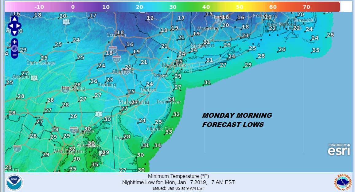
Weather conditions will improve tonight with skies partially clearing out leading to a better Sunday. This low strenthens as it passes near Nova Scotia Sunday so look for gusty winds and some sunshine and temperatures in the 40s. Cold air from Eastern Canada moves southward Sunday night and we will wake up to cold temperatures Monday morning with lows in the upper teens to mid 20s in most areas.
Monday we will have the next 2 weather systems approaching with a warm front coming through Monday night. Look for some sunshine giving way to arriving clouds. Monday will be a cold day with highs just in the low to mid 30s. Look for a brief burst of rain sleet or wet snow Monday evening that won’t amount to much if anything at all. Temperature will hold steady or rise a bit into Tuesday. Then a cold front approaches with the chance for a rain shower late Tuesday into Tuesday evening with highs in the 40s.
COLDER PATTERN BEGINS WEDNESDAY
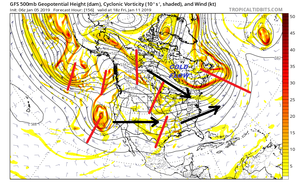
Wednesday of next week begins the arrival of a colder weather pattern overall as the upper pattern continues to slowly change. Sunshine and clouds for Wednesday with a gusty wind and temperatures in the 40s will give way to at least 5 days of temperatures near or below average beginning on Thursday. The jet stream pattern moving through later next week is different from what we have seen in the last 2 weeks or so. The screaming Pacific jet that floods the US with generally milder air weakens considerably. On the Atlantic side the blocking high over England completely breaks down. We begin to see the establishment of a polar flow from Northwest Canada to the Northeast with various shortwaves moving along. To the south a second jet with a developing split flow provides it’s own set of short wave troughs moving along. As far as snow threats are concerned it will be all about the “phasing” of the two streams..or not..and the timing of weather systems moving along. Certainly weather models will react from run to run and snow weenies will go from rejoice to despair as they react from model run to model run in almost rabid irrationality. There will be storm threats developing along the way for the second half of the month and it will simply depend on the two jet streams timing out just right..like is always the case. Plain and simple. Winter weather in the middle of winter is an utterly groundbreaking concept but that is really what we have coming.
MANY THANKS TO TROPICAL TIDBITS FOR THE USE OF MAPS
Please note that with regards to any tropical storms or hurricanes, should a storm be threatening, please consult your local National Weather Service office or your local government officials about what action you should be taking to protect life and property.


