Rain Moving Northeastward Raw Rainy Tuesday
Rain Moving Northeastward Raw Rainy Tuesday
Latest satellite & radar loops are showing the next round of rain developing from Central & Southern New Jersey southward and moving northeast however if you look closely at the satellite loop you can see the turning of clouds in upstate NY. This upper air disturbance is attempting to suppress this area of rain to the south of New York City Long Island & Connecticut so there will be a bit of a battle underway through tonight. The rain shield looks to get only so far north before being pushed more east so we will basically be watching the radar for trends through the rest of the day. The risk of rain will be in the forecast overnight however the best chances will be as you head south from NYC & Long Island southward with not much happening in areas north of there.
SATELLITE LOOP

RAIN MOVING NORTHEAST REGIONAL RADAR

RAIN MOVING NORTHEAST LOCAL RADAR NEW YORK CITY

RAIN MOVING NORTHEAST LOCAL RADAR PHILADELPHIA


This leads to forecast issues for Tuesday. With the strong upper air system pretty much sitting overhead and low pressure to the southeast, we will have a damp raw onshore flow so look for occasional light rain or drizzle. The risk will be there all day long. Temperatures will in many areas not get out of the 50s.

As far as rainfall is concern most areas could wind up seeing under half an inch with heavier rains to the south across Central and South Jersey & Southeastern Pennslyvania and north of Route 84 in the Hudson Valley & Connecticut. For all the clouds and dampness, not much rain will be produced.

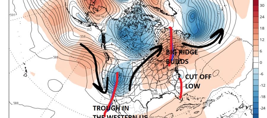
There is room for some optimism on Wednesday which will start out damp and dreary but there is a chance that dry air from the north could move in later in the day. The onshore flow will still be there but highs should be back into the 60s and any rain will be minimal. We pretty much have to wait for the upper air storm in the Northeast to pull away offshore for genuine improvement. That should begin on Thursday barring last minute complications. The pattern looks to flip this weekend to one that will bring some heat here beginning Sunday where some spots could hit 90 and next Monday when we should see highs in the low 90s away from the ocean.
 GET JOE A CIGAR IF YOU LIKE

LANDSCAPE COMPANIES FOR YOUR NEEDS
LONG ISLAND ROCKLAND COUNTY Connecticut

![]()

ROCKLAND COUNTY TRI STATE SNOW REMOVAL JOHNSTOWN PA


FiOS1 News Weather Forecast For Long Island
FiOS1 News Weather Forecast For New Jersey
FiOS1 News Weather Forecast For Hudson Valley
NATIONAL WEATHER SERVICE SNOW FORECASTS
LATEST JOESTRADAMUS ON THE LONG RANGE
Weather App

Don’t be without Meteorologist Joe Cioffi’s weather app. It is really a meteorologist app because you get my forecasts and my analysis and not some automated computer generated forecast based on the GFS model. This is why your app forecast changes every 6 hours. It is model driven with no human input at all. It gives you an icon, a temperature and no insight whatsoever.
It is a complete weather app to suit your forecast needs. All the weather information you need is right on your phone. Android or I-phone, use it to keep track of all the latest weather information and forecasts. This weather app is also free of advertising so you don’t have to worry about security issues with your device. An accurate forecast and no worries that your device is being compromised.
Use it in conjunction with my website and my facebook and twitter and you have complete weather coverage of all the latest weather and the long range outlook. The website has been redone and upgraded. Its easy to use and everything is archived so you can see how well Joe does or doesn’t do when it comes to forecasts and outlooks.
Just click on the google play button or the apple store button on the sidebar for my app which is on My Weather Concierge. Download the app for free. Subscribe to my forecasts on an ad free environment for just 99 cents a month.
Get my forecasts in the palm of your hand for less than the cost of a cup of Joe!


