
Rain Grazing New Jersey Long Island Tuesday
Rain Grazing New Jersey Long Island Tuesday
Potential tropical storm development from the low pressure center off the Southeast Coast is becoming less and less likely. The satellite loop shows that this system has more of the look of a non tropical storm system you would see in the late fall winter and early spring rather than a tropcial one. Most of the rain and wind is occurring well north and east of the center. During the day Tuesday an area of rain will creep northward and probably reach Route 78 in New Jersey to NYC & Long Island for a short time. In New Jersey & Southeastern Pennsylvania south of route 195 the rain will be steadier and a bit heavier but overall this is not going to be a big deal. Even though the low will develop into a major gale center in the ocean, it will be far enough offshore to spare us any major issues. Gales will be over the coastal waters and look for the beaches to get roughed up for a couple of days as the storm heads toward and passes south of the Canadian Maritime Provinces.
SATELLITE LOOP

REGIONAL RADAR

You can see the rain building on the regional radar to the south and moving slowly north northeastward. Again at some point the rain will stop moving north and move more eastward. This should cause any rain to end during tomorrow evening. Areas north and west of the coast will probably see very little rain. In any event with an overcast and a northeast winds, temperatures Tuesday will probably not get out of the 60s.
LOCAL RADAR NEW YORK CITY

LOCAL RADAR PHILADELPHIA


Wednesday we see improvement with sunshine and highs in the 70s to near 80. Then a cold front arrives late Thursday which will be a warm day with highs into the 80s with the chance for some late showers or a thunderstorm
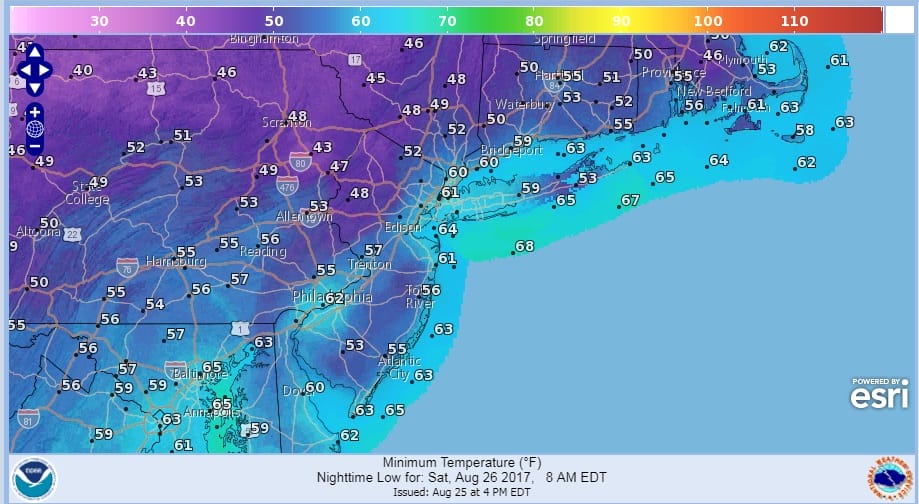
Friday in comes the cool air with gusty winds and sunshine and highs just in the upper 60s to lower 70s and Saturday morning will be very cool with lows in the 40s in many places north and west of the coast. Along the coast and in warmer urban areas lows will be in the very cool low 50s. As far as the weekend is concerned, Saturday we will see sunshine giving way to arriving clouds with highs in the 70s. Then depending on the next cold front arriving on Sunday and the remnants of Harvey we could see some rain or showers with highs in the 70s. Labor Day looks dry with sunshine and highs in the upper 70s to lower 80s.
 GET JOE A CIGAR IF YOU LIKE

FiOS1 News Weather Forecast For Long Island
FiOS1 News Weather Forecast For New Jersey
FiOS1 News Weather Forecast For Hudson Valley


