Nice Weather Before Late Week Noreaster Rain Wind Coastal Flooding & Snow?
Nice Weather Before Late Week Noreaster
Rain Wind Coastal Flooding & Snow?
We begin this Tuesday morning with a cloud free sky and sunshine across the land. After the miserable weekend and a day of fighting off leftover clouds we finally have a nice day to enjoy. Temperatures this afternoon will reach the low and mid 50s except near south facing shorelines where the sea breeze will be dropping temperatures this afternoon. There are no issues through Wednesday. Skies will be clear tonight with most lows in the 30s, 20s in the cold spots. Wednesday looks good too though we will have arriving clouds with morning sunshine and highs again in the 50s. That is the easy part of the forecast.
US SATELLITE

REGIONAL RADAR

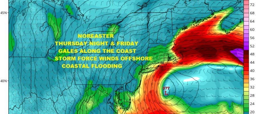
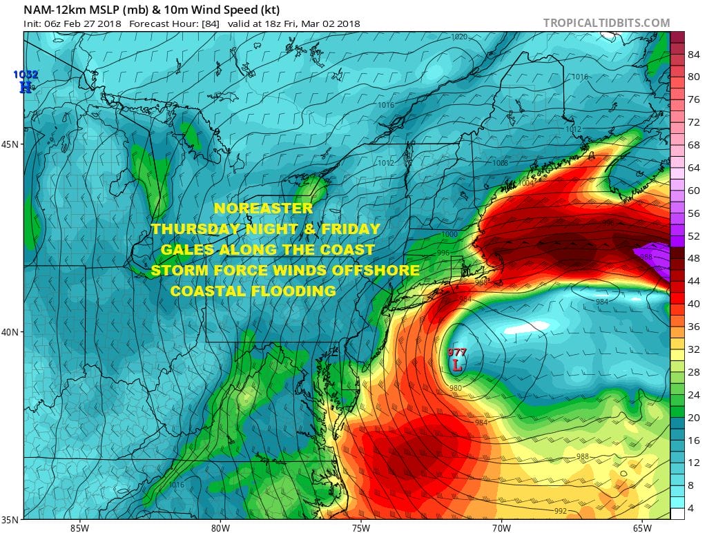
Thursday we start to go downhill. Low pressure moves across the Ohio Valley and redevelops off the Delaware coast. Upper air dynamics pointing to a major storm developing with strong winds & heavy rain beginning later Thursday and lasting into Friday night. Weather models overnight and this morning are not that far apart in the idea of a major storm sitting just south of Long Island Friday morning and then dropping slowly southward. Front and center I believe will be coastal flooding which will occur over several high tide cycles beginning Friday morning. This storm is coming with a full moon so I would expect moderate coastal flooding at the very least over most areas from Long Island and Coastal Connecticut southward to New Jersey & Delaware.
NAM RAINFALL FORECAST THROUGH FRIDAY AFTERNOON
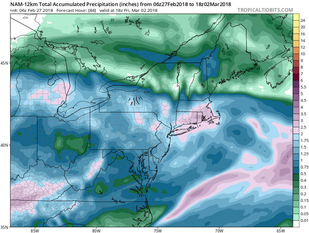
Through Friday 1pm rainfall forecast on the NAM model is substantial and I go along with the models storm position and how it handles this. This suggests at the very least a 1 to 3 inch rainfall area wide with some places getting more that get under what we call the “comma head” which is located near and just north and west of the low center.
NAM SNOW FORECAST THROUGH FRIDAY 1PM
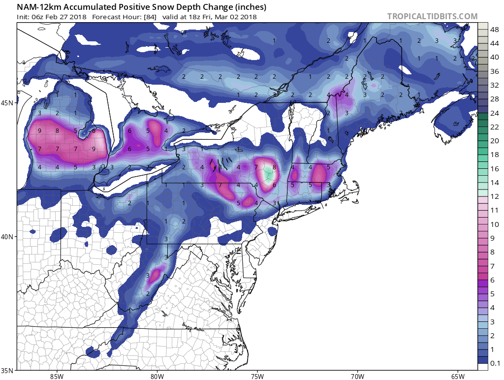
As for the snow question I think I want to wait on this for another day or so. This looks like a typical late season elevation driven snow scenario given that cold air is lacking. We will have to do it all with dynamics of which there are plenty to work with. The trick is figuring out when and where. All the models seem to be hinting around at this to varying degrees. I think for the coast it is a bit of a tougher sell though not impossible. You can see from the NAM snow map where the snowfall through early Friday afternoon is forecast which is for inland north and west of the coast. We need more time to analyze this so lets leave this door open for now and we will come back to it later today.
 GET JOE A CIGAR IF YOU LIKE

FiOS1 News Weather Forecast For Long Island
FiOS1 News Weather Forecast For New Jersey
FiOS1 News Weather Forecast For Hudson Valley


