Clearing Skies Eastern US Coastal Storm Late Week
Clearing Skies Eastern US Coastal Storm Late Week

It has taken all day for dry air to move down from Upstate NY as clouds lingered along the coast. The rain from the weekend weather system at least stayed to our south or offshore. Now we can look ahead to a well deserved break for the next 2 days with nothing but dry air all the way back to the Rockies. Skies should clear out nicely tonight. There isn’t much cold air in the Eastern US so temperatures tonight will be in the reasonable 30s except 20s in cold spots. Radars will shut down over the next 2 days.
US SATELLITE

REGIONAL RADAR

LOCAL RADAR NEW YORK CITY

LOCAL RADAR PHILADELPHIA


Tuesday looks very nice with sunshine dry conditions and temperatures will warm up into the 50s. Wednesday should be a repeat performance with sunshine giving way to some late day clouds as a weak cold front approaches. Highs here will also be in the 50s.
The front that is coming through Wednesday night will actually dissipate as it passes through. Winds will shift to the northeast and this will start the process of weather conditions deteriorating on Thursday. Clouds will increase and thicken up. Rain looks to arrive later Thursday afternoon and then continue into Friday.
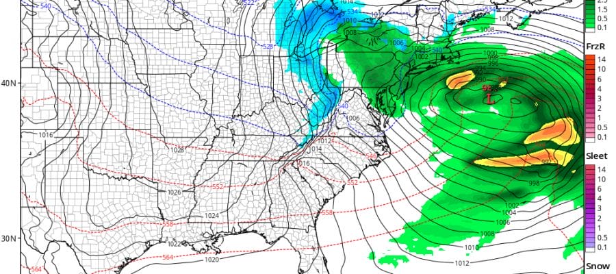
Low pressure coming out of the Ohio Valley is blocked from tracking to our west and will be forced to redevelop off the Delaware Coast. This sets us up for a coastal storm with wind, rain, and coastal flooding. Given that we have a full moon on Thursday this puts coastal flooding front and center as the biggest issue with this storm. Rain and wind will be there too but this will wind up being a secondary issue at this point. If snow is going to come into play it is probably going to be inland and elevation driven. There just doesn’t seem to be enough cold air to create serious snow concerns at this point. Temperatures will be in the raw upper 30s to mid 40s through all of this. Rain and wind should begin to taper off Friday night with improving weather conditions on Saturday. Tides however could remain an issue through the weekend.
 GET JOE A CIGAR IF YOU LIKE

FiOS1 News Weather Forecast For Long Island
FiOS1 News Weather Forecast For New Jersey
FiOS1 News Weather Forecast For Hudson Valley


