Noreaster Gales Tides Coastal Flooding Late Week
Noreaster Gales Tides Coastal Flooding Late Week
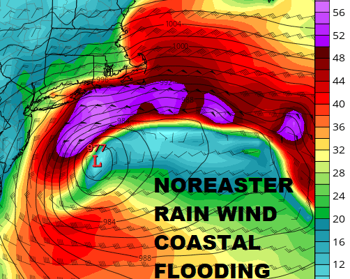
Overnight weather models remain on course for the first Noreaster of size to impact the region in quite a long time. This storm is coming in conjunction with a full moon so this could be a serious coastal flooding event for Long Island & New Jersey. This will all be dependent on low track and wind direction. Also this is going to be a long duration event as the storm will take 2 days to clear the coastal and then it will spend several more days offshore. This will mean multiple tide cycles to work through over at least several days. Put gales and/or storm force winds on top of this and you have a recipe for major tidal flooding issues. We will speak to this specifically in the coming days. The purple in the map above showing winds in excess of sustained 50 knots which will be just offshore. Sustained gales are forecast from New Jersey to Southern New England on the GFS model. The other models line up with a similar picture. This will all get underway late Thursday with rain and wind at their strongest Thursday night into Friday evening before the storm drops southeastward.
GFS RAINFALL FORECAST THROUGH SATURDAY EVENING MARCH 3, 2018
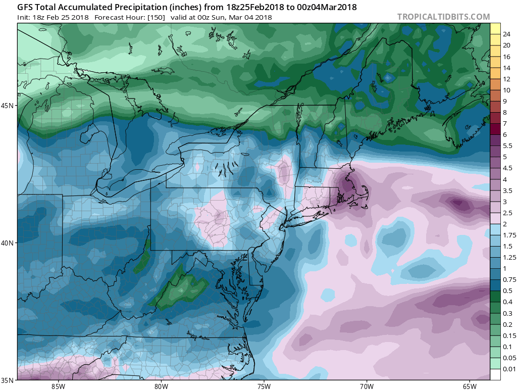
Rainfall amounts could be substantial as well on the order of 2 to 3 inches in some areas. Recent rainfalls have alleviated all dry conditions to where we area now well above average for rainfall so flash flooding could become an issue as well. We will be discussing this storm further later today. Snow does not appear to be an issue with this given the lack of cold air though a mix of a change to wet snow before ending can’t be ruled out especially inland.
US SATELLITE

REGIONAL RADAR

Meanwhile we do have cloud issues to start the day as clearing has been slow to occur. Rain is on the radar across Virginia and North Carolina but this should pass well to our south, though the clouds will linger for awhile across Southern New Jersey and Southeastern Pennsylvania. They may be the last to clear out today. Areas to the north should clear out faster and see clouds give way to some sunshine.
LOCAL RADAR NEW YORK CITY

LOCAL RADAR PHILADELPHIA


Afternoon highs will be in the 50s. Skies should be nice and clear tonight with lows in the 30s…20s in cold spots. Tuesday and Wednesday look nice with some sunshine with highs into the 50s. Then weather conditions deteriorate Thursday as the noreaster begins to take shape.
 GET JOE A CIGAR IF YOU LIKE

FiOS1 News Weather Forecast For Long Island
FiOS1 News Weather Forecast For New Jersey
FiOS1 News Weather Forecast For Hudson Valley


