Nice Dry Quiet Sunday And Week Ahead Storm Signals Next Weekend
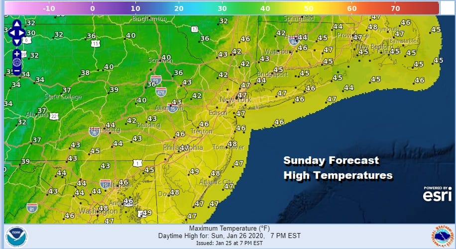
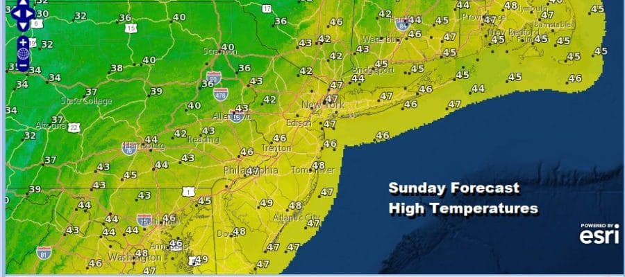
The second half of the weekend will be a lot better than the first. Satellite pictures show skies have cleared out for the most part though there are some patchy clouds around here and there. Overall though it is a nice day for the last Sunday in January with temperatures today that will be mostly in the mid to upper 40s. This is not to shabby for this time of year. The regional radar is showing a few rain and snow showers across parts of upstate NY but this is not going to amount to much of anything.
SATELLITE

REGIONAL RADAR

We do have a weak cold front that moves through tonight which starts a very slow stair step decline in temperatures over the next few days but there is no arctic air in the mix. So we edge down to temperatures that will be close to average for this time of year and settle for that. This week will also be dry thanks to high pressure that settles into the Northeast and Middle Atlantic states with no major issues other than clouds passing through from time to time. Monday’s highs will be a repeat of today with temperatures in the 40s. Tuesday we will see highs mostly in the upper 30s and lower 40s. Wednesday and Thursday highs will be mostly in the 30s. Nights will turn colder as well as the week progresses but nothing out of the ordinary.

Friday will bring sunshine followed by arriving clouds as we set the table for the next storm system for the first weekend of February. Weather models have been circling around this time frame with a rather wide spread and a number of options regarding timing. The issue of cold air (or the lack of it) remains for the urban I-95 corridor while it might be colder just inland north and west to support some snow from this. Also this will depend on timing of features in the upper atmosphere which right now are all over the place and difficult to see clarity on how they come together. This will be our forecast challenge for this coming week.
BE SURE TO DOWNLOAD THE FREE METEOROLOGIST JOE CIOFFI WEATHER APP &
ANGRY BEN’S FREE WEATHER APP “THE ANGRY WEATHERMAN!
MANY THANKS TO TROPICAL TIDBITS FOR THE USE OF MAPS
Please note that with regards to any severe weather, tropical storms, or hurricanes, should a storm be threatening, please consult your local National Weather Service office or your local government officials about what action you should be taking to protect life and property.


