Major Storm Threat Growing For Tuesday

Major Storm Threat Growing For Tuesday
After today’s runs of weather models I think we can safely conclude that a major storm threat for the Middle Atlantic & Northeastern US is growing. All the weather models show an intensifying storm moving up the east coast however as usual 4 days out we have some differences and those differences will be crucial in determining who gets what especially in terms of snow. And as usual 2 models have locked into their own ideas on how this plays and neither one has yet to cave to the other.
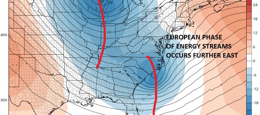
MAJOR STORM EUROPEAN MODEL MONDAY THROUGH WEDNESDAY
CLICK TO ANIMATE

The European model is actually quite simple. It would be a 1 to 2 foot snow storm from Northern Virginia to New England. It has an offshore track (depending on which model source you use that takes an intensifying low from the Carolinas to the Gulf of Maine. The track would be right through the “box” to near the benchmark 40N-70W and there would be no mixing issues or rain of consequence. It would be snow for everyone.
MAJOR STORM THREAT TUESDAY-WEDNESDAY EUROPEAN MODEL UPPER AIR
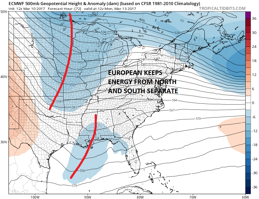
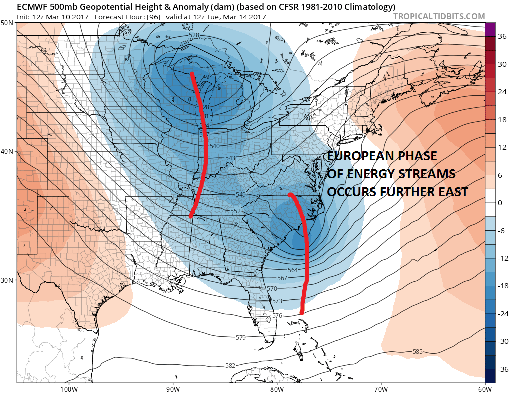
The GFS has a different look with the two systems. It is much deeper with the northern energy where it swings it around and goes “negative tilt faster than the European. The “phase” of the north and the south occurs earlier.
MAJOR STORM GFS MODEL UPPER AIR TUESDAY MORNING

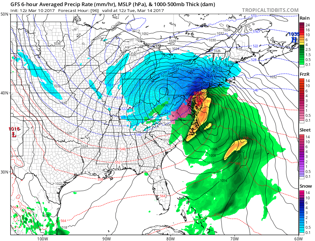
The early phase means the surface low tracks further west and hugs the coast at least for while and that creates mixing and rain issues for coastal areas. This could still mean several to many inches for the coast before any change and a foot plus for areas just inland.
Right now I think we are getting something. I can’t yet rule out the coast hugger idea of the GFS. The Canadian and the NAM model would support the European view vs the GFS. There is still more to go here as far as model watching but by late tomorrow or early Sunday we could see which model will cave to which.
MANY THANKS TO TROPICAL TIDBITS FOR THE WONDERFUL USE OF THE MAPS

GET JOE A CIGAR IF YOU LIKE!
SNOW REMOVAL COMPANIES FOR YOUR WINTER NEEDS
LONG ISLAND ROCKLAND COUNTY Connecticut

![]()

ROCKLAND COUNTY TRI STATE SNOW REMOVAL JOHNSTOWN PA


FiOS1 News Weather Forecast For Long Island
FiOS1 News Weather Forecast For New Jersey
FiOS1 News Weather Forecast For Hudson Valley
NATIONAL WEATHER SERVICE SNOW FORECASTS
LATEST JOESTRADAMUS ON THE LONG RANGE
Weather App

Don’t be without Meteorologist Joe Cioffi’s weather app. It is really a meteorologist app because you get my forecasts and my analysis and not some automated computer generated forecast based on the GFS model. This is why your app forecast changes every 6 hours. It is model driven with no human input at all. It gives you an icon, a temperature and no insight whatsoever.
It is a complete weather app to suit your forecast needs. All the weather information you need is right on your phone. Android or I-phone, use it to keep track of all the latest weather information and forecasts. This weather app is also free of advertising so you don’t have to worry about security issues with your device. An accurate forecast and no worries that your device is being compromised.
Use it in conjunction with my website and my facebook and twitter and you have complete weather coverage of all the latest weather and the long range outlook. The website has been redone and upgraded. Its easy to use and everything is archived so you can see how well Joe does or doesn’t do when it comes to forecasts and outlooks.
Just click on the google play button or the apple store button on the sidebar for my app which is on My Weather Concierge. Download the app for free. Subscribe to my forecasts on an ad free environment for just 99 cents a month.
Get my forecasts in the palm of your hand for less than the cost of a cup of Joe!
![]()
