Bitter Cold Weekend Looming Storm Threat Ahead
Bitter Cold Weekend Looming Storm Threat Ahead
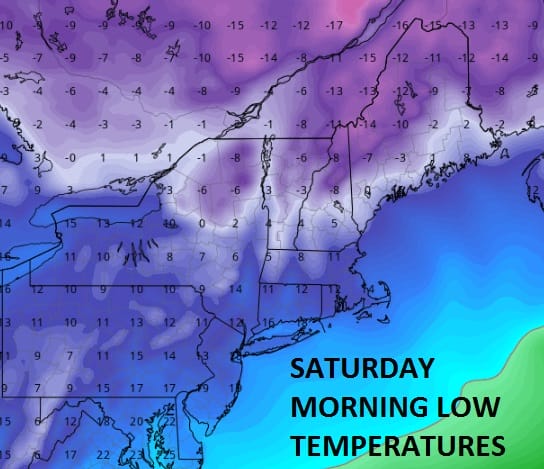
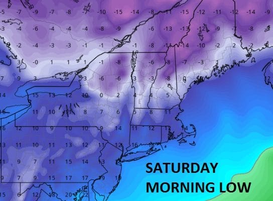
Friday’s little storm system is now intensifying as it moves past Nova Scotia ushering in a very cold air mass for the weekend. Temperatures through Monday will be some 15 more degrees below average. At least we should see a fair amount of ineffective sunshine both Saturday and Sunday. Dry air is evident on the satellite loop but there are some snow showers to the north and west. There could be a spot snow shower Saturday in one or two isolated spots. Highs both Saturday and Sunday will be in the upper 20s and lower 30s and nights will be down in the teens. When you seasonally adjust for 15 or more degrees below normal for a day in January, this air mass would be the equivalent of a January day where temperatures would top in the upper teens and low 20s and lows would be down in the low single digits!
SATELLITE LOOP

REGIONAL RADAR

LOCAL RADAR NEW YORK CITY

LOCAL RADAR PHILADELPHIA


Snow showers are still dotting the radar at the moment but we expect these snow showers to disappear soon enough
Monday we will see sunshine giving way to arriving clouds as we get ready for a storm that is going to develop off the Southeast US coast and move up the coast. Again the issue of whether this is going to be a coast hugger meaning rain and sleet issues, or is the track offshore which means colder air and mostly snow. Overnight weather models should at least lay the trend between the GFS which is further west and warmer and the European which is further east, more intense and colder.
 GET JOE A CIGAR IF YOU LIKE

SNOW REMOVAL COMPANIES FOR YOUR WINTER NEEDS
LONG ISLAND ROCKLAND COUNTY Connecticut

![]()

ROCKLAND COUNTY TRI STATE SNOW REMOVAL JOHNSTOWN PA


FiOS1 News Weather Forecast For Long Island
FiOS1 News Weather Forecast For New Jersey
FiOS1 News Weather Forecast For Hudson Valley
NATIONAL WEATHER SERVICE SNOW FORECASTS
LATEST JOESTRADAMUS ON THE LONG RANGE
Weather App

Don’t be without Meteorologist Joe Cioffi’s weather app. It is really a meteorologist app because you get my forecasts and my analysis and not some automated computer generated forecast based on the GFS model. This is why your app forecast changes every 6 hours. It is model driven with no human input at all. It gives you an icon, a temperature and no insight whatsoever.
It is a complete weather app to suit your forecast needs. All the weather information you need is right on your phone. Android or I-phone, use it to keep track of all the latest weather information and forecasts. This weather app is also free of advertising so you don’t have to worry about security issues with your device. An accurate forecast and no worries that your device is being compromised.
Use it in conjunction with my website and my facebook and twitter and you have complete weather coverage of all the latest weather and the long range outlook. The website has been redone and upgraded. Its easy to use and everything is archived so you can see how well Joe does or doesn’t do when it comes to forecasts and outlooks.
Just click on the google play button or the apple store button on the sidebar for my app which is on My Weather Concierge. Download the app for free. Subscribe to my forecasts on an ad free environment for just 99 cents a month.
Get my forecasts in the palm of your hand for less than the cost of a cup of Joe!


