Long Range Continues Warm East Cool West
SHOP THE JOESTRADAMUS STORE

Long Range Continues Warm East Cool West
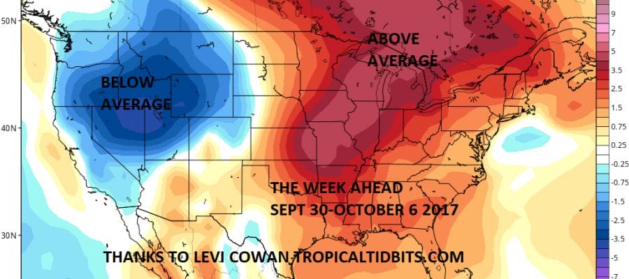
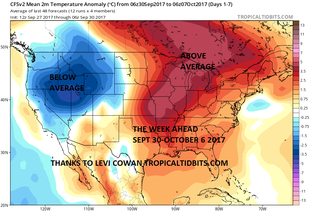
As we look ahead into the long range we seem to have entered a warmer than average period of weather in the Eastern US and a cooler than average weather pattern in the Western US. This of course will mean occasional brief exceptions to this scheme and we are seeing that going on right now as a strong upper trough swings offshore the Eastern US.
That trough set off some fireworks today with thunderstorms scattered over parts of the area particularly Central Long Island that produced several waterspouts and flash flooding in some areas. All that weather is now shifting offshore as low pressure develops southeast of Long Island and heads to the east. Skies will gradually clear out as the satellite loop shows that upper air disturbance moving to the east rather quickly. Temperatures overnight will drop into the 40s just about everywhere except around the warmer urban locations. Dry air over the Midwest with high pressure will bring lots of sunshine for Sunday but it will be cool with highs in the 60s to near 70 degrees. There will be no showers to worry about on Sunday and through the middle of this coming week.
SATELLITE LOOP

REGIONAL RADAR

You can see on the radar that the showers from earlier continue to drop southeastward and offshore so the rains are done. Radars will soon go silent for a rather lengthy stretch.
LOCAL RADAR NEW YORK CITY

LOCAL RADAR PHILADELPHIA


Monday we should be back into the low and middle 70s with sunshine and we will add a few degrees more on Tuesday with highs in the middle to upper 70s and Wednesday we should see temperatures back into the 80s with sunshine each day. The next 2 weather fronts look rather weak so don’t expect much of a cool down until the overall upper air pattern makes a major switch.
As for the tropics after one of the most active and intense hurricane periods in many years, the tropics look to quiet down. The only area where development may be possible is the Northwest Caribbean and Eastern Gulf of Mexico later in the week however conditions only look to be marginally conducive for development. Weather models show hints of tropical development late next week but they have backed off from prior ideas of more robust activity.
 GET JOE A CIGAR IF YOU LIKE

FiOS1 News Weather Forecast For Long Island
FiOS1 News Weather Forecast For New Jersey
FiOS1 News Weather Forecast For Hudson Valley


