HURRICANE WATCH POSTED FOR MOST OF NORTH & SOUTH CAROLINA
WEATHER MODELS NUDGED A BIT WEST
CATEGORY 4 HURRICANE COULD STRENGTHEN LATER TODAY
…HURRICANE AND STORM SURGE WATCHES ISSUED FOR PORTIONS OF THE
COASTS OF NORTH AND SOUTH CAROLINA…
SUMMARY OF 500 AM AST…0900 UTC…INFORMATION
———————————————-
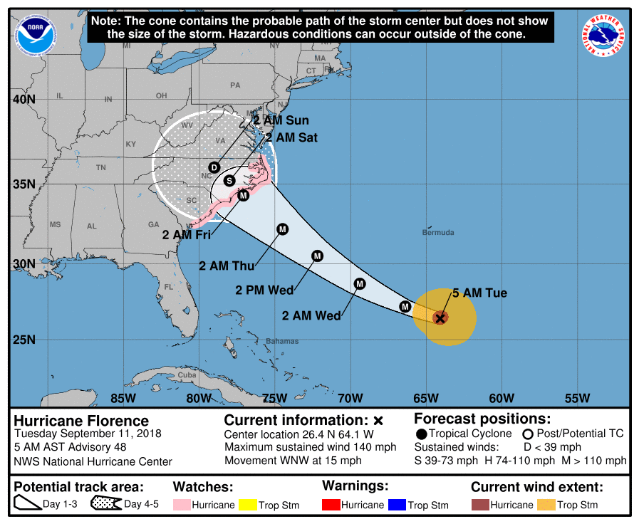
LOCATION…26.4N 64.1W
ABOUT 410 MI…660 KM S OF BERMUDA
ABOUT 975 MI…1570 KM ESE OF CAPE FEAR NORTH CAROLINA
MAXIMUM SUSTAINED WINDS…140 MPH…220 KM/H
PRESENT MOVEMENT…WNW OR 290 DEGREES AT 15 MPH…24 KM/H
MINIMUM CENTRAL PRESSURE…944 MB…27.88 INCHES
WATCHES AND WARNINGS
——————–
CHANGES WITH THIS ADVISORY:
A Storm Surge Watch has been issued for the east coast of the
United States from Edisto Beach, South Carolina northward to
the North Carolina-Virginia border, including the Pamlico and
Albemarle Sounds.
A Hurricane Watch has been issued for the east coast of the United
States from Edisto Beach, South Carolina, northward to the
North Carolina-Virginia border, including the Pamlico and Albemarle
Sounds.
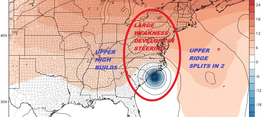
The Hurricane Watch covers a rather large geographic area given the high uncertainty regarding the track. Weather models have shifted west and show two issues that make this a potential long duration dangerous event. The storm slows down considerably as it reaches the coast and we will likely see some unusual things regarding a stall or a loop. This could create a large area which experience hurricane conditions. Then it is a move inland where heavy rains will spread into interior North Carolina & Virginia over the weekend and into next week. This is going to be around for awhile.
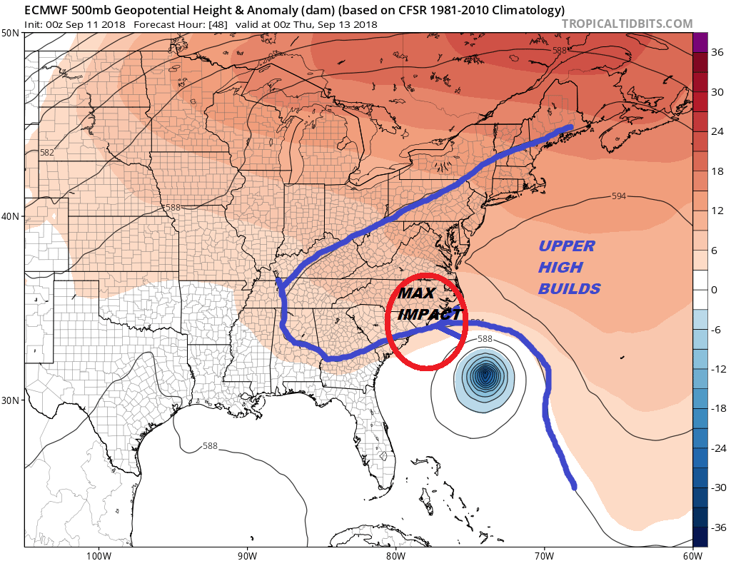
The driver is the upper ridge to the northeast of Florence which will be building into Thursday but there is going to be a change in the structure of that upper high as Florence approaches the coast.

The upper high splits in two with the western part of the ridge strengthening. This causes Florence to slow down and all the global models show Florence literally straddling the coast and either stalling or dowing a very slow loop/drift right along the immediate coast. Normally they move inland and when a storm moves inland you deal with rain and not much else. With this storm slowing down like this near the coast it could mean a high coastal impact regarding storm surge tides and winds along with the rain. It could extend over a large area. The Hurricane Centers forecast at the moment is shows a storm inching inland. This potential for slowing/stalling/looping is a big concern.

How slow does this move? Well the models argue for taking the remnant storm/low into the Central Appalachians. That map is for next Monday evening. It will take 4 to 5 days for the system to move from landfall to a few hundred miles to the northwest. This scenario means excessive rains for a large area.

The Weather Prediction Center shows a large area of 10-15 inches of rain. Rather than try an pick a number the bottom line is that will see extensive flooding over a large area of the MIddle Atlantic states for whoever lies north and northeast of the track of Florence.
WIDE ATLANTIC TROPICAL SATELLITE

WESTERN ATLANTIC TROPICAL SATELLITE

Florence is likely to strengthen to a category 5 in the next 2 days as conditions are very favorable aloft. Right now Florence is undergoing an eye wall replacement cycle where pressures fluctuate. As Florence makes its final approach to the coast it is likely to do so as a category 4 hurricane. We will be livestreaming this morning on my Youtube channel at 9am Eastern and again at 7pm eastern time. We will be streaming live on Facebook with the JOE & JOE WEATHER SHOW at 9:15pm Eastern Time on my facebook page.
THANKS TO TROPICAL TIDBITS FOR THE USE OF MAPS
Please consult your local National Weather Service office at weather.gov for the latest information on any tropical or storms or hurricanes that could be a threat to your area. Consult your local government officials regarding action you may need to take to secure life and property
FiOS1 News Weather Forecast For Long Island
FiOS1 News Weather Forecast For New Jersey
FiOS1 News Weather Forecast For Hudson Valley