
HURRICANE FLORENCE CATEGORY 4 140 MPH
HURRICANE WATCHES LIKELY TO GO UP TUESDAY IN CAROLINAS
WARM FRONT MOVES NORTHWARD TROPICAL AIR RETURNS NORTHEAST
We have been seeing temperatures rise overnight as a warm front comes up from the south. It struggled on Monday and now it is making some headway. The upper high from the Atlantic is beginning to build. This all part of the atmosphere setting the table for the arrival of Hurricane Florence. More in Florence in a moment. First though we will continue to sit in clouds overnight with some passing showers along with some fog as the warm air takes over.
EASTERN SATELLITE

REGIONAL RADAR

All the steady rain has moved well north of the area. Local radars are still picking up some showers and downpours but the last of those showers are going through. There could possibly be a few more showers bubbling up around daybreak in some areas.
LOCAL RADAR NEW YORK CITY

LOCAL RADAR PHILADELPHIA


The rest of the week we will sit in warm and humid conditions. A weak cold front will approach and basically fall apart on top of us over the next several days which means there will be some downpours and perhaps even some thunderstorms popping up from time to time. Temperatures will rise and reach into the 80s each day. With Florence to the south of us we don’t expect anything here from the hurricane until after it makes landfall late Thursday along the Carolina coast. Depending on the track we may not see any rains from this until early next week as a cold front arrives from Canada and picks up the remnant moisture and bring it northward. That is a rather complex puzzle to resolve and we won’t begin to get a handle on that until we know what Florence does.
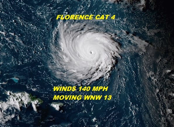
Florence remains a category 4 hurricane though the first round of rapid strengthening has stopped for the moment which is not unusual. The eye wall is replacing itself and when that happens the strength tends to fluctuate a bit. Another round of strengthening is likely Tuesday and Florence has a shot to reach category 5 at some point in the next 2 days.
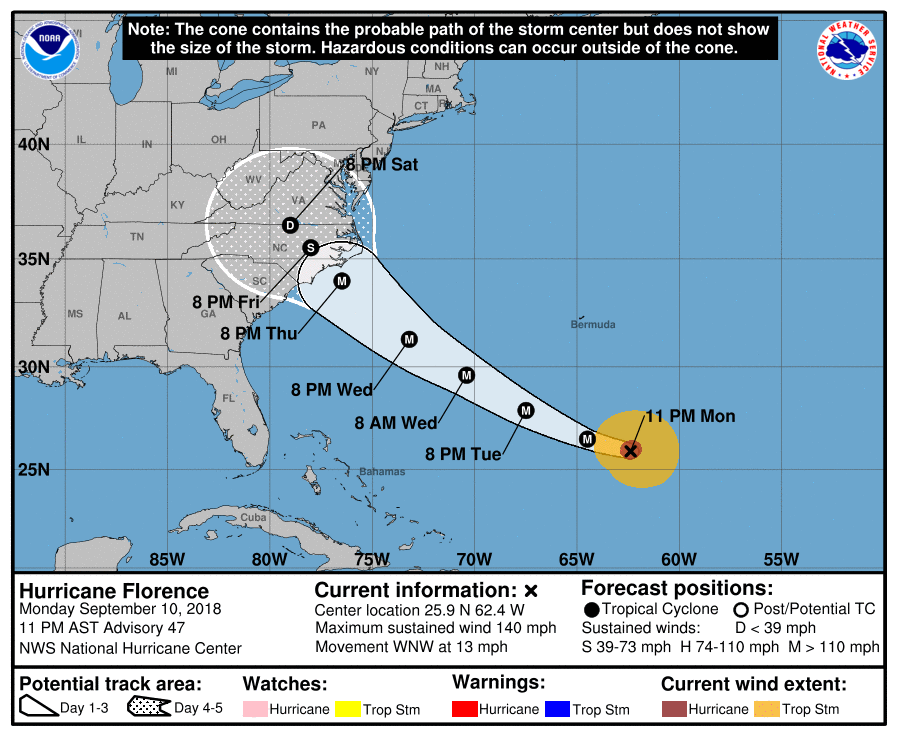
There have been minor changes to the forecast track from the National Hurricane Center with a slight eastward adjustment. The change wasn’t major in nature. The forecast track idea of a hurricane going inland remains the same even though some global models slow the storm down before landfall and loop it around before bringing it inland. There may be surprises in store in the coming days so pay close attention to the forecasts and updates.
MIDNIGHT VIDEO UPDATE 9/11/18
MANY THANKS TO TROPICAL TIDBITS FOR THE USE OF MAPS
Please note that with regards to any tropical storms or hurricanes, should a storm be threatening, please consult your local National Weather Service office or your local government officials about what action you should be taking to protect life and property.
LATEST JOESTRADAMUS ON THE LONG RANGE


