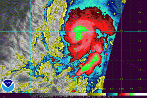
A few hours ago an accelerating Hurricane Patricia came ashore as a category 5 hurricane. Weakening has begun for the hurricane that set all time records for wind speed and pressure in the western hemisphere. This morning winds were at 200 mph and the pressure hit 879 millibars or 25.95 inches which is unbelievable. Puerto Vallarta, Mexico took a direct hit from the storm when the eye came ashore this evening. It won’t be until morning when they can survey the damage.
SUMMARY OF 700 PM CDT...0000 UTC...INFORMATION
----------------------------------------------
LOCATION...19.5N 104.9W
ABOUT 50 MI...85 KM WNW OF MANZANILLO MEXICO
ABOUT 135 MI...220 KM SW OF GUADALAJARA MEXICO
MAXIMUM SUSTAINED WINDS...160 MPH...260 KM/H
PRESENT MOVEMENT...NNE OR 15 DEGREES AT 15 MPH...24 KM/H
MINIMUM CENTRAL PRESSURE...924 MB...27.29 INCHES


WATCHES AND WARNINGS
--------------------
CHANGES WITH THIS ADVISORY:

None.

SUMMARY OF WATCHES AND WARNINGS IN EFFECT:

A Hurricane Warning is in effect for...
* San Blas to Punta San Telmo

A Hurricane Watch is in effect for...
* East of Punta San Telmo to Lazaro Cardenas

A Tropical Storm Warning is in effect for...
* East of Punta San Telmo to Lazaro Cardenas
* North of San Blas to El Roblito
Patricia will continue to weaken but it is moving rather quickly and it should cross the mountains of Northern Mexico and emerge in the Western Gulf of Mexico on Saturday. Weather models including the European and the GFS models among others quickly develop a low in the northwest Gulf of Mexico. There is a chance this could become tropical until it moves northeast into Lousiana later Sunday or Sunday night. Ultimately it will be an extratropical system and bring rains to the midwest and eventually the northeast where the rainfall is much needed.
We have the latest forecasts for the New York New Jersey Eastern Pennsylvania Southern New England area along with the latest model analysis on what will happen with all this moisture. My latest FiO1 News Weather broadcast for New Jersey for the weekend explains what is happening with the jet stream and why the moisture from Patricia could head our way.


