Hurricane Nicole 100 MPH Warnings Bermuda
Hurricane Nicole 100 MPH Warnings Bermuda

Even on this wide satellite view, Hurricane Nicole has a signature look and a very large eye. Nicole is aiming right for Bermuda and weather models are in agreement that Nicole will move either very close to or right over the Island Thursday morning. Conditions favor further strengthening and Nicole could be a major hurricane when it reaches Bermuda.

BULLETIN
HURRICANE NICOLE INTERMEDIATE ADVISORY NUMBER  34A
NWS NATIONAL HURRICANE CENTER MIAMI FL       AL152016
200 PM AST WED OCT 12 2016

...LARGE EYE OF NICOLE MOVING NORTHWARD TOWARD BERMUDA...
...CONDITIONS TO BEGIN TO DETERIORATE ON BERMUDA THIS EVENING...


SUMMARY OF 200 PM AST...1800 UTC...INFORMATION
----------------------------------------------
LOCATION...28.8N 66.8W
ABOUT 270 MI...435 KM SSW OF BERMUDA
MAXIMUM SUSTAINED WINDS...100 MPH...155 KM/H
PRESENT MOVEMENT...N OR 360 DEGREES AT 8 MPH...13 KM/H
MINIMUM CENTRAL PRESSURE...969 MB...28.62 INCHES


WATCHES AND WARNINGS
--------------------
CHANGES WITH THIS ADVISORY:

None.

SUMMARY OF WATCHES AND WARNINGS IN EFFECT:

A Hurricane Warning is in effect for...
* Bermuda

A Hurricane Warning means that hurricane conditions are expected
somewhere within the warning area.  Preparations to protect life
and property should be rushed to completion.

For storm information specific to your area, please monitor
products issued by your national meteorological service.


DISCUSSION AND 48-HOUR OUTLOOK
------------------------------
At 200 PM AST (1800 UTC), the large and distinct eye of Hurricane
Nicole was located near latitude 28.8 North, longitude 66.8 West.
Nicole is moving toward the north near 8 mph (13 km/h).  A turn
toward the north-northeast and an increase in forward speed is
expected tonight.  A northeast turn with an additional increase in
forward speed is forecast on Tuesday.  On the forecast track, the
core of Hurricane Nicole will pass near or over Bermuda on Thursday.

Maximum sustained winds are near 100 mph (155 km/h) with higher
gusts.  Some strengthening is possible during the next 24 hours, and
Nicole could be near major hurricane strength when it approaches
Bermuda.

Hurricane-force winds extend outward up to 45 miles (75 km) from
the center, and tropical-storm-force winds extend outward up to 160
miles (260 km).

The estimated minimum central pressure is 969 mb (28.62 inches).


HAZARDS AFFECTING LAND
----------------------
WIND:  Hurricane conditions are expected to begin on Bermuda
Thursday morning, with tropical storm conditions expected to begin
this evening.

STORM SURGE:  A dangerous storm surge will raise water levels by as
much as 6 to 8 feet above normal tide levels in Bermuda.  The surge
will be accompanied by large and destructive waves.

RAINFALL:  Nicole is expected to produce total rain accumulations
of 4 to 8 inches over Bermuda through Thursday.

SURF:  Swells associated with Nicole will affect Bermuda during the
next few days.  These swells will create dangerous surf conditions
and rip currents.  Please refer to products being issued by the
Bermuda Weather Service.
Local Weather Conditions

Other than some patchy clouds that are moving through from time to time this afternoon, our weather remains dry with partly sunny skies. Temperatures are in the 60s. Tonight with clouds around we will see lows in the upper 40s to mid 50. Thursday looks partly sunny but there could be a few late day widely scatttered showers mainly in areas north of New York City.
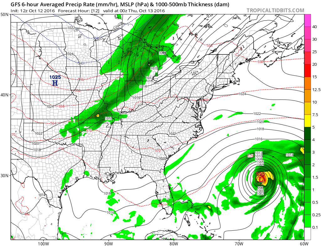
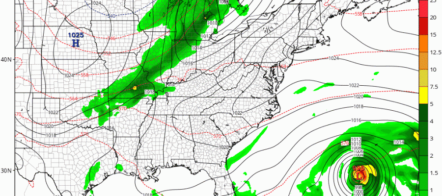
You can see on the GFS model that the showers are limited with the weather front. You can also see how the model takes Nicole right over Bermuda. High pressure will be building in for Friday and the weekend with sunshine all three days and temperatures a bit on the cool side. Highs will only be in the low to mid 60s each day with Saturday being the coolest day. No rain is forecast until late Monday as another weather front approaches.
In case you missed it yesterday JOESTRADMUS takes a look a Siberian snow cover and what that means for Winter 2016-2017. Other winter preview stories and videos are below.
WINTER WEATHER OUTLOOK VIDEOS
In case you missed them I’ve been previewing the upcoming winter in a series of posts and videos. Here are the first 2. More will be coming along. Links to the latest posts are below.
NEW JERSEY
LONG ISLAND AND NEARBY
WINTER 2016-2017 PART 3 NEW JERSEY
WINTER 2016-2017 PART 1 OCEAN WATER TEMPERATURES
WINTER 2016-2017 PART 2 ARCTIC SEA ICE AND SIBERIAN SNOW COVER
FiOS1 News Weather Forecast For Long Island
FiOS1 News Weather Forecast For New Jersey
FiOS1 News Weather Forecast For Hudson Valley
NATIONAL WEATHER SERVICE SNOW FORECASTS
LATEST JOESTRADAMUS ON THE LONG RANGE

Weather App

Don’t be without Meteorologist Joe Cioffi’s weather app. It is really a meteorologist app because you get my forecasts and my analysis and not some automated computer generated forecast based on the GFS model. This is why your app forecast changes every 6 hours. It is model driven with no human input at all. It gives you an icon, a temperature and no insight whatsoever.
It is a complete weather app to suit your forecast needs. All the weather information you need is right on your phone. Android or I-phone, use it to keep track of all the latest weather information and forecasts. This weather app is also free of advertising so you don’t have to worry about security issues with your device. An accurate forecast and no worries that your device is being compromised.
Use it in conjunction with my website and my facebook and twitter and you have complete weather coverage of all the latest weather and the long range outlook. The website has been redone and upgraded. Its easy to use and everything is archived so you can see how well Joe does or doesn’t do when it comes to forecasts and outlooks.
Just click on the google play button or the apple store button on the sidebar for my app which is on My Weather Concierge. Download the app for free. Subscribe to my forecasts on an ad free environment for just 99 cents a month.
Get my forecasts in the palm of your hand for less than the cost of a cup of Joe!

MENTION JOE CIOFFI AND GET A 5% DISCOUNT


