Autumn Leaves Are Falling
Autumn Leaves Are Falling
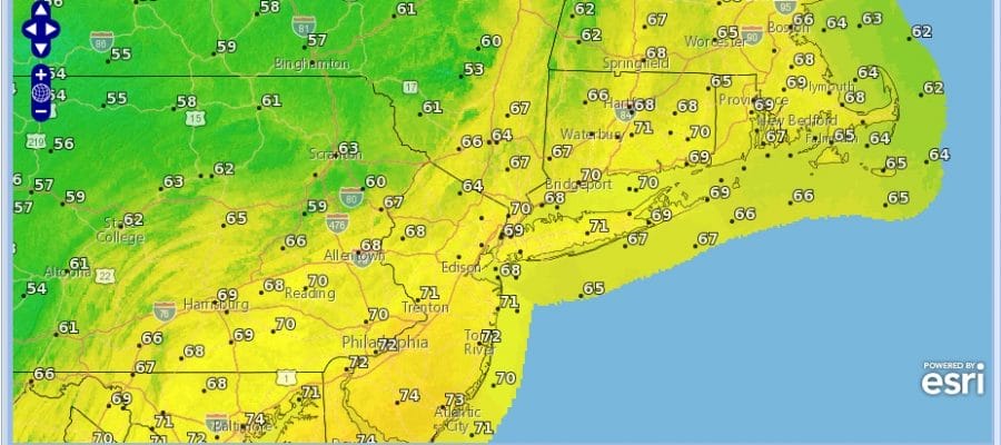
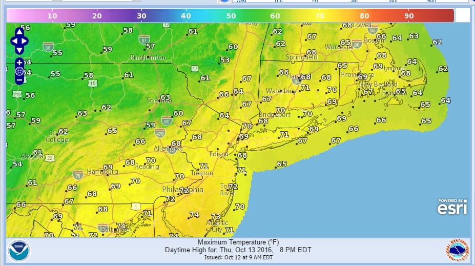
After a night with clouds and slightly higher dew points, the temperatures started this morning a good 5 to 10 degrees higher than yesterday. We have sunshine through most of the area based on the satellite loop which doesn’t show much. We should see highs in the the mid to upper 60s this afternoon The loop also shows the next cold front approaching and this will be moving through later on Thursday with not much diffiuclty other than clouds and maybe a shower well north and west of the coast. Otherwise Thursday it is a mix of sun and clouds with highs in the low to mid 70s.


There really isn’t too much happening to speak of other than Hurricane Nicole which will hit Bermuda late tonight and early Thursday as at least a category 2 hurricane. Friday we see the next dry air mass build into the northeast which will mean sunny and rather cool mid October temperatures right through the weekend.
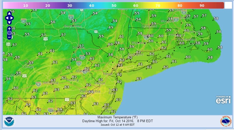
Highs will be in the low to mid 60s at best all three days..some areas away from the coast Friday might have a tough time getting out of the 50s for highs. Autumn leaves are falling and this weekend will be great for fall foliage viewing especially as you head north and west of coastal areas.
BULLETIN
HURRICANE NICOLE INTERMEDIATE ADVISORY NUMBER  33A
NWS NATIONAL HURRICANE CENTER MIAMI FL       AL152016
800 AM AST WED OCT 12 2016

...HURRICANE HUNTER AIRCRAFT INVESTIGATING NICOLE...


SUMMARY OF 800 AM AST...1200 UTC...INFORMATION
----------------------------------------------
LOCATION...28.0N 66.9W
ABOUT 320 MI...520 KM SSW OF BERMUDA
MAXIMUM SUSTAINED WINDS...100 MPH...155 KM/H
PRESENT MOVEMENT...NNW OR 335 DEGREES AT 5 MPH...7 KM/H
MINIMUM CENTRAL PRESSURE...969 MB...28.61 INCHES


WATCHES AND WARNINGS
--------------------
CHANGES WITH THIS ADVISORY:

None.

SUMMARY OF WATCHES AND WARNINGS IN EFFECT:

A Hurricane Warning is in effect for...
* Bermuda

A Hurricane Warning means that hurricane conditions are expected
somewhere within the warning area.  A warning is typically issued
36 hours before the anticipated first occurrence of tropical-storm-
force winds, conditions that make outside preparations difficult or
dangerous.  Preparations to protect life and property should be
rushed to completion.

For storm information specific to your area, please monitor
products issued by your national meteorological service.


DISCUSSION AND 48-HOUR OUTLOOK
------------------------------
At 800 AM AST (1200 UTC), the large and distinct eye of Hurricane
Nicole was located near latitude 28.0 North, longitude 66.9 West.
Nicole is moving toward the north-northwest near 5 mph (7 km/h),
but a turn toward the north with an increase in forward speed is
expected later today. An additional increase in forward speed with a
turn toward the north-northeast is forecast on Thursday. On the
forecast track, the core of Hurricane Nicole will near Bermuda on
Thursday.

Maximum sustained are near 100 mph (155 km/h) with higher gusts.
Some strengthening is possible during the next 36 hours, and Nicole
could be near major hurricane strength later today.

Hurricane-force winds extend outward up to 30 miles (45 km) from
the center, and tropical-storm-force winds extend outward up to 115
miles (185 km).

The latest minimum central pressure measured by an Air Force Reserve
reconnaissance aircraft is 969 mb (28.61 inches).


HAZARDS AFFECTING LAND
----------------------
WIND:  Hurricane conditions are expected to begin on Bermuda
Thursday morning, with tropical storm conditions expected to begin
tonight.

STORM SURGE:  A dangerous storm surge is expected to produce coastal
flooding in Bermuda.  Near the coast, the surge will be accompanied
by large and destructive waves.

RAINFALL:  Nicole is expected to produce total rain accumulations
of 4 to 8 inches over Bermuda through Thursday.

SURF:  Swells associated with Nicole will affect Bermuda during the
next few days.  These swells will create dangerous surf conditions
and rip currents.  Please refer to products being issued by the
Bermuda Weather Service.
Stories of note yesterday include JOESTRADAMUS with the latest on WINTER 2016-2017 and the role of Siberian Snow cover. Take a look if you haven’t seen it complete with video!
WINTER WEATHER OUTLOOK VIDEOS
In case you missed them I’ve been previewing the upcoming winter in a series of posts and videos. Here are the first 2. More will be coming along. Links to the latest posts are below.
NEW JERSEY
LONG ISLAND AND NEARBY
WINTER 2016-2017 PART 3 NEW JERSEY
WINTER 2016-2017 PART 1 OCEAN WATER TEMPERATURES
WINTER 2016-2017 PART 2 ARCTIC SEA ICE AND SIBERIAN SNOW COVER
FiOS1 News Weather Forecast For Long Island
FiOS1 News Weather Forecast For New Jersey
FiOS1 News Weather Forecast For Hudson Valley
NATIONAL WEATHER SERVICE SNOW FORECASTS
LATEST JOESTRADAMUS ON THE LONG RANGE

Weather App

Don’t be without Meteorologist Joe Cioffi’s weather app. It is really a meteorologist app because you get my forecasts and my analysis and not some automated computer generated forecast based on the GFS model. This is why your app forecast changes every 6 hours. It is model driven with no human input at all. It gives you an icon, a temperature and no insight whatsoever.
It is a complete weather app to suit your forecast needs. All the weather information you need is right on your phone. Android or I-phone, use it to keep track of all the latest weather information and forecasts. This weather app is also free of advertising so you don’t have to worry about security issues with your device. An accurate forecast and no worries that your device is being compromised.
Use it in conjunction with my website and my facebook and twitter and you have complete weather coverage of all the latest weather and the long range outlook. The website has been redone and upgraded. Its easy to use and everything is archived so you can see how well Joe does or doesn’t do when it comes to forecasts and outlooks.
Just click on the google play button or the apple store button on the sidebar for my app which is on My Weather Concierge. Download the app for free. Subscribe to my forecasts on an ad free environment for just 99 cents a month.
Get my forecasts in the palm of your hand for less than the cost of a cup of Joe!

MENTION JOE CIOFFI AND GET A 5% DISCOUNT


