Hurricane Matthew GFS Model & Euro Model Analysis
Hurricane Matthew GFS Model & Euro Model Analysis

Satellite loops show an inner core developing and deepening continues at the rate of about 1 mb an hour. Gradual strengthening is forecast over the next few days. Matthew could become a major hurricane in the Central Caribbean. We will be examining the latest weather models and will post about them once the European model cycle is done.

GFS MODEL & EUROPEAN MODEL ANALYSIS
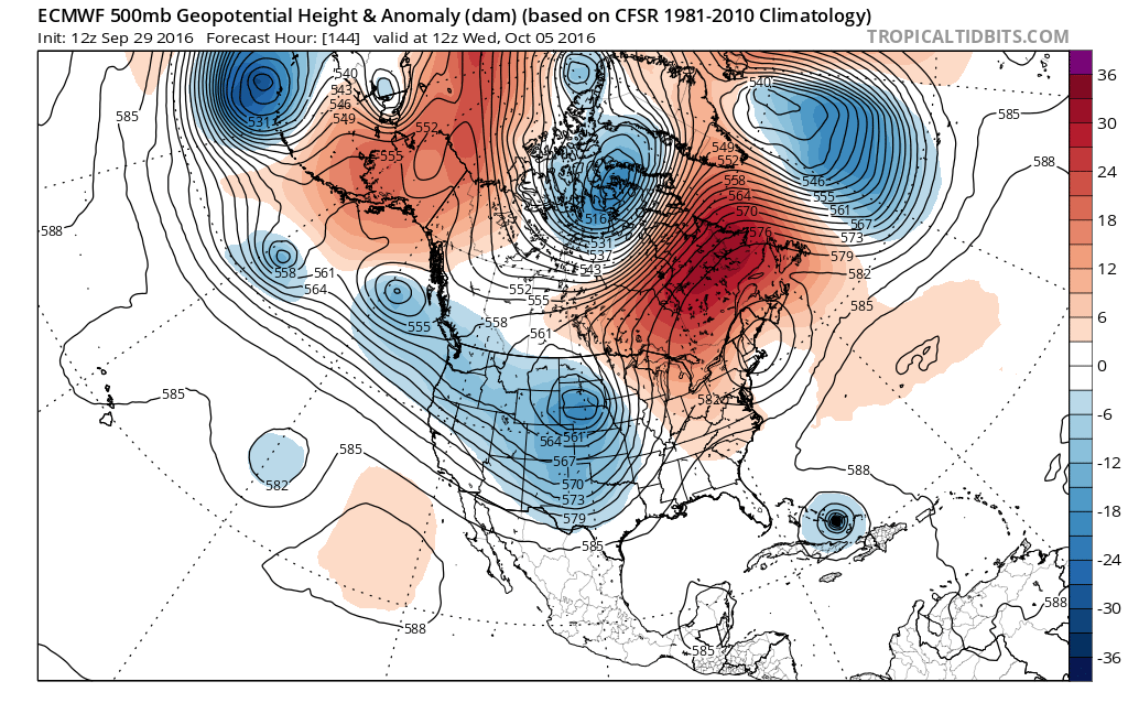
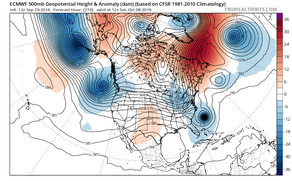
The video from this morning illustrated how the GFS model last night changed its view of how the trough in the west was going to behave. The more progressive look on that particular run was another model flip into a different direction. As expected, models have now gone back to the idea of a deep trough coming into the Plains and Middle Mississippi Valley. Both the GFS model and the European model show this.

You can see the gears here on the GFS model are a throw back to two days ago where the model showed the deep trough in the Plains gradually lifting northward and pulling Hurricane Matthew closer to the coast.
The European model is not that different from the GFS in the Plains but it is a little different in the east with what’s left of the East coast cut off low now in the Ohio Valley still holding a presence off the coast of Maine. It is also a bit slower with Hurricane Matthew has it has the hurricane further south at this point. It looks about 12 hours slower.
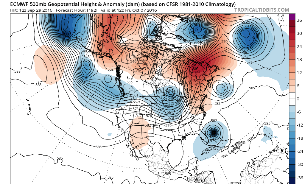
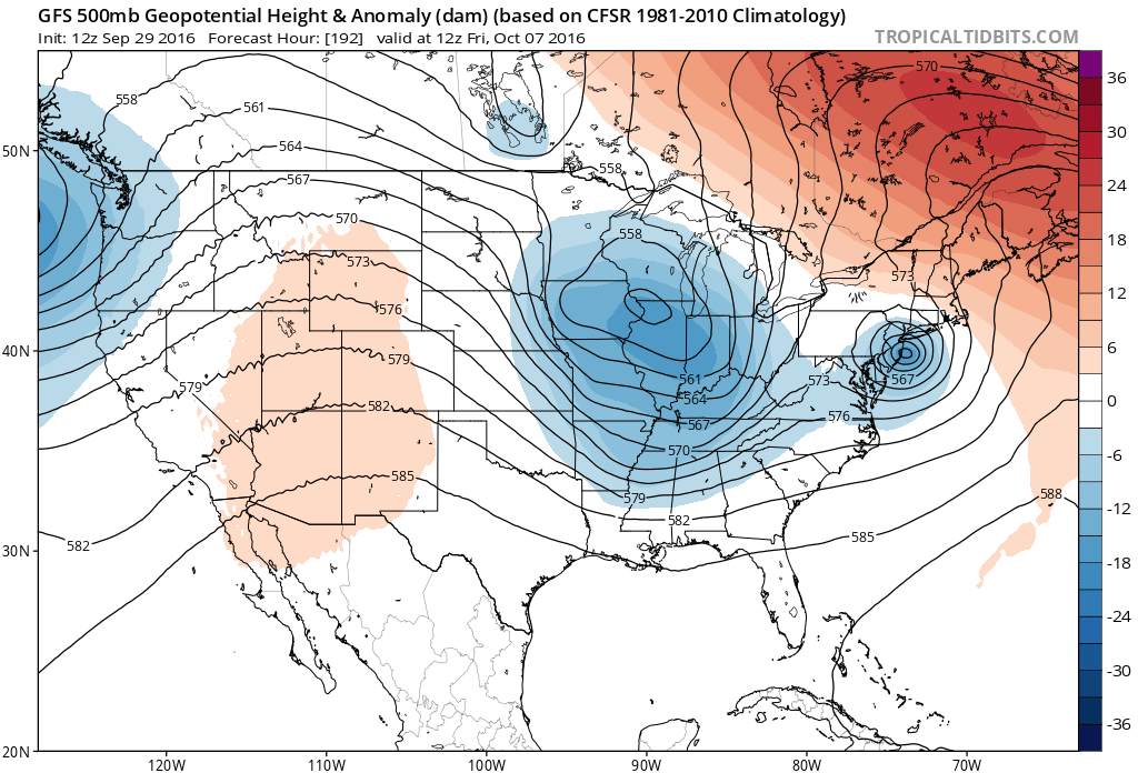
The difference widens by 192 hours or day 8 as the GFS times everything almost perfectly with the deep upper trough swinging and cutting off over Illinois and capturing Hurricane Matthew and bringing it right up the coast. Being the European is slower the timing is different and the trough is not quite as deep as the GFS model This would pull Hurricane Matthew northward and then northeastward offshore and parallel the Southeast coast. The trough at Day 9 would line up and take Matthew north northeast and out to sea.
HURRICANE MATTHEW KEYS TO THE FORECAST
Obviously the speed and timing of the hurricane with the deep trough in the west is of utmost importance. The GFS timed everything perfectly for a serious threat along the East Coast from the Carolinas to New England. The European is 12 hours slower and the western trough less deep and more progressive (moving west to east).
Also key to this is the system that is coming into the Pacific Northwest coast which helps to prevent this system from cutting off in Illinois on the European. The GFS keeps more of that energy off the Pacific coast which allows the Plains system to intensify and “cut off”.
Obviously nothing has been resolved with this model run but at least we know what we are dealing with in terms of the jet stream dynamics. Which model is more correct with the timing of Hurricane Matthew? The European model strengthens this to at least a category 3 hurricane when it is off the Southeast coast of the US, while the GFS is at a category 1 or perhaps a 2. Still lots of unknowns and still many days of forecasting headaches ahead of us.
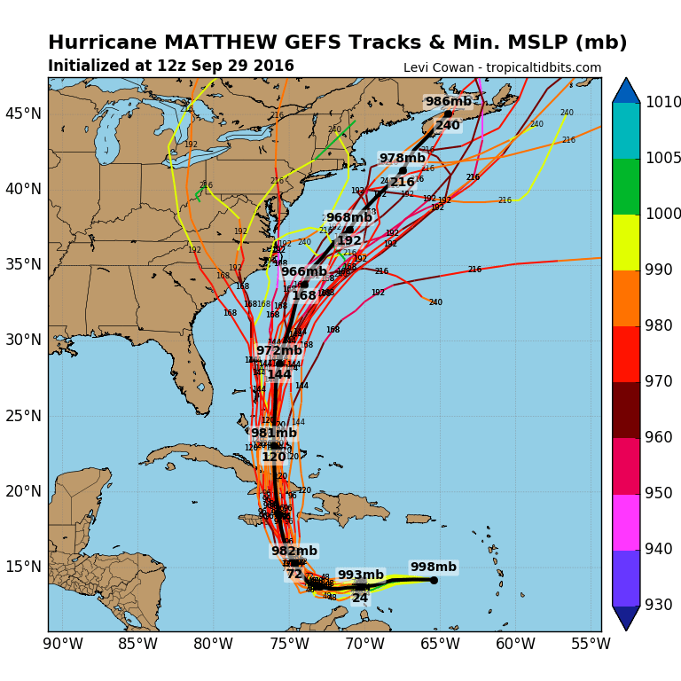
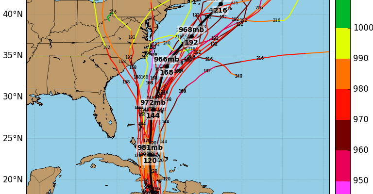
Most of the spaghetti plots of the numerous hurricane models take Hurricane Matthew offshore to the northeast with just a handful making landfall. They are all clustered within 100 miles or so of each other until we get closer to North Carolina.
WINTER 2016-2017 PART 1 OCEAN WATER TEMPERATURES
WINTER 2016-2017 PART 2 ARCTIC SEA ICE AND SIBERIAN SNOW COVER
WINTER 2016-2017 PART 3 NEW JERSEY PREVIEW
WINTER 2016-2017 PART 4 EASTERN PENNSYLVANIA PREVIEW
FiOS1 News Weather Forecast For Long Island
FiOS1 News Weather Forecast For New Jersey
FiOS1 News Weather Forecast For Hudson Valley
NATIONAL WEATHER SERVICE SNOW FORECASTS
LATEST JOESTRADAMUS ON THE LONG RANGE
Weather App

Don’t be without Meteorologist Joe Cioffi’s weather app. It is really a meteorologist app because you get my forecasts and my analysis and not some automated computer generated forecast based on the GFS model. This is why your app forecast changes every 6 hours. It is model driven with no human input at all. It gives you an icon, a temperature and no insight whatsoever.
It is a complete weather app to suit your forecast needs. All the weather information you need is right on your phone. Android or I-phone, use it to keep track of all the latest weather information and forecasts. This weather app is also free of advertising so you don’t have to worry about security issues with your device. An accurate forecast and no worries that your device is being compromised.
Use it in conjunction with my website and my facebook and twitter and you have complete weather coverage of all the latest weather and the long range outlook. The website has been redone and upgraded. Its easy to use and everything is archived so you can see how well Joe does or doesn’t do when it comes to forecasts and outlooks.
Just click on the google play button or the apple store button on the sidebar for my app which is on My Weather Concierge. Download the app for free. Subscribe to my forecasts on an ad free environment for just 99 cents a month.
Get my forecasts in the palm of your hand for less than the cost of a cup of Joe!
![]()
![]()