
Coastal Flood Warning Flash Flood Watch New Jersey
Coastal Flood Warning
Flash Flood Watch New Jersey
Gale Warnings Along The Coast
The blocking big high pressure area to the north is wedging down the east coast. With low pressure to the south and east of New Jersey it has created a strong onshore flow. This means the likelihood of moderate to possibly major coastal flooding at high tides beginning tonight and lasting into Friday mornings high tide.
..MULTIPLE TIDE CYCLES OF TIDAL INUNDATION FLOODING ANTICIPATED
INTO AT LEAST FRIDAY MORNING ALONG THE ATLANTIC COASTS OF NEW
JERSEY AND DELAWARE...

.A BLOCKED PATTERN OF STRONG EASTERLY SURFACE WINDS WILL CONTINUE
INTO AT LEAST FRIDAY MORNING. THIS ALREADY CAUSED STORM SURGES OF
AROUND 1 TO 2 FEET THIS MORNING. THAT SURGE SHOULD INCREASE TO
2.5 FEET TONIGHT ALONG THE SOUTHERN NEW JERSEY AND DELAWARE
ATLANTIC COASTS AS THE EASTERLY WIND STRENGTHENS 5 TO 10 MPH
STRONGER THAN WHAT OCCURRED THIS MORNING. WINDS SHOULD DIMINISH
CONSIDERABLY DURING THE DAYLIGHT HOURS FRIDAY ALONG THE DELAWARE
AND FAR SOUTHERN NEW JERSEY COASTS.

DEZ002-003-NJZ020>023-027-300500-
/O.CON.KPHI.CF.W.0006.160929T2200Z-160930T0500Z/
KENT-INLAND SUSSEX-OCEAN-CUMBERLAND-ATLANTIC-CAPE MAY-
SOUTHEASTERN BURLINGTON-
402 PM EDT THU SEP 29 2016

...COASTAL FLOOD WARNING REMAINS IN EFFECT UNTIL 1 AM EDT
FRIDAY...

* LOCATION...COASTAL NEW JERSEY AND DELAWARE AND THE LOWER
  DELAWARE BAY.

* COASTAL FLOODING...WATER LEVELS HAVE REMAINED ELEVATED SINCE THE
  HIGH TIDE THIS MORNING...WITH MODERATE COASTAL FLOODING ALREADY
  OCCURRING IN SOME LOCATIONS. EVACUATIONS HAVE BEEN REPORTED IN
  THESE LOCATIONS...WITH MAJOR COASTAL FLOODING POSSIBLE.

* TIMING...ONGOING COASTAL FLOODING IS EXPECTED AND WILL PEAK WITH
  THE HIGH TIDE WHICH WILL OCCUR BETWEEN 7 AND 9 PM ON THE OCEAN
  FRONT. HIGH TIDE ON THE DELAWARE BAY AND BACK BAYS MAY OCCUR UP
  TO THREE HOURS LATER.

* WAVES...AROUND 3 TO 5 FEET.

* SURGE...TIDES WILL BE AROUND 2 FEET ABOVE ASTRONOMICAL TIDES.
  HEAVY RAIN AT THE TIME OF HIGH TIDES COULD EXACERBATE COASTAL
  FLOODING...LEADING TO TOTAL WATER LEVELS EVEN HIGHER.

* IMPACTS...ROADWAY FLOODING IS EXPECTED NEAR BOTH HIGH TIDES.

* OUTLOOK...AT LEAST MINOR TIDAL INUNDATION FLOODING IS
  ANTICIPATED WITH THE FRIDAY MORNING HIGH TIDE CYCLE... AND
  POSSIBLY AGAIN FRIDAY EVENING.
In addition we have Flash Flood Watches up for New Jersey along and south of Route 195. Moderate ot heavy rains on the radar in the southern half of New Jersey and extending eastward into the ocean will be moving north northwestward. Look for waves of rain and some of it heavy to spread northward across the state and eventually to areas north northeast and northwest of New York City including Long Island and Connecticut.


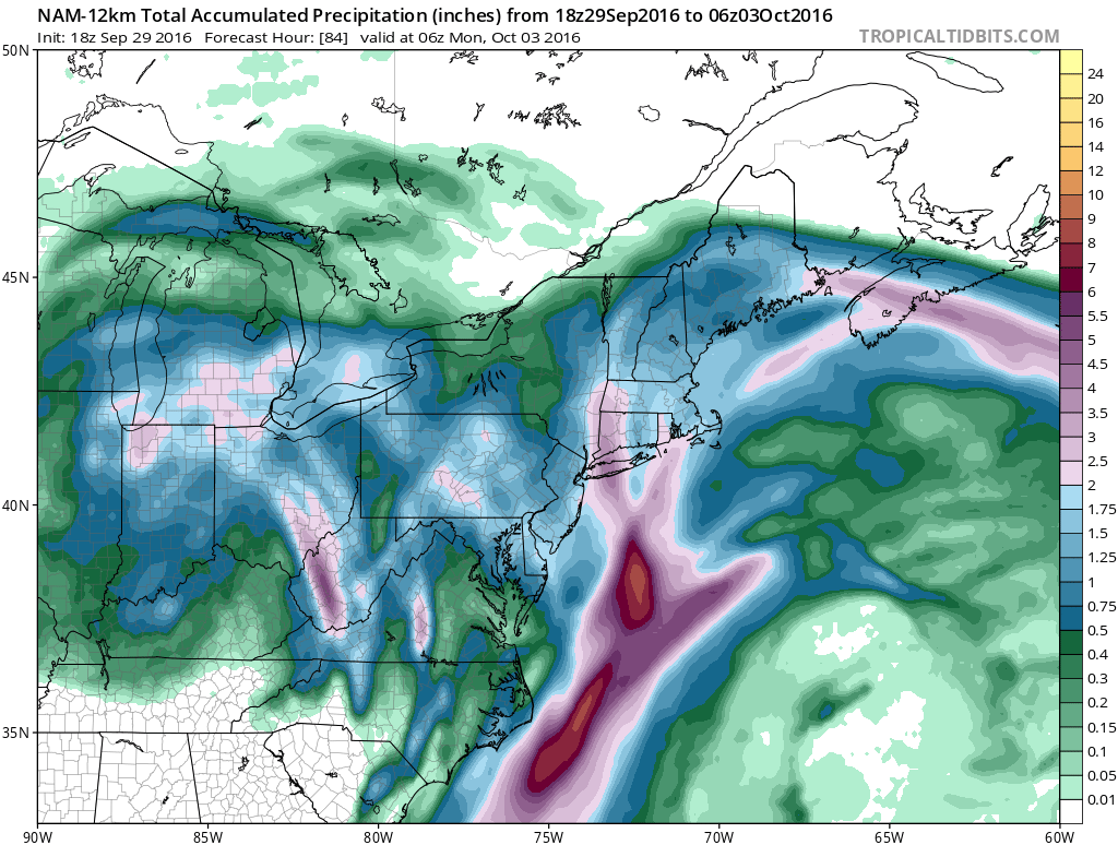
SALEM-GLOUCESTER-CAMDEN-NORTHWESTERN BURLINGTON-OCEAN-CUMBERLAND-
ATLANTIC-CAPE MAY-ATLANTIC COASTAL CAPE MAY-COASTAL ATLANTIC-
COASTAL OCEAN-SOUTHEASTERN BURLINGTON-DELAWARE-PHILADELPHIA-
INCLUDING THE CITIES OF...PENNSVILLE...GLASSBORO...CAMDEN...
CHERRY HILL...MOORESTOWN...MOUNT HOLLY...JACKSON...MILLVILLE...
HAMMONTON...CAPE MAY COURT HOUSE...OCEAN CITY...ATLANTIC CITY...
LONG BEACH ISLAND...WHARTON STATE FOREST...MEDIA...PHILADELPHIA
301 PM EDT THU SEP 29 2016

...FLASH FLOOD WATCH IN EFFECT THROUGH FRIDAY AFTERNOON...

THE NATIONAL WEATHER SERVICE IN MOUNT HOLLY HAS EXPANDED THE

* FLASH FLOOD WATCH TO INCLUDE PORTIONS OF SOUTHERN NEW JERSEY
  AND SOUTHEAST PENNSYLVANIA...INCLUDING THE FOLLOWING AREAS...
  IN SOUTHERN NEW JERSEY...ATLANTIC...ATLANTIC COASTAL CAPE
  MAY...CAMDEN...CAPE MAY...COASTAL ATLANTIC...COASTAL OCEAN...
  CUMBERLAND...GLOUCESTER...NORTHWESTERN BURLINGTON...OCEAN...
  SALEM AND SOUTHEASTERN BURLINGTON. IN SOUTHEAST PENNSYLVANIA...
   DELAWARE AND PHILADELPHIA.

* THROUGH FRIDAY AFTERNOON

* HEAVY RAINFALL ASSOCIATED WITH LOW PRESSURE WILL AFFECT THE AREA
  THROUGH FRIDAY. THE HEAVIEST RAINS WILL TAPER OFF AFTER DAYBREAK
  FRIDAY. WIDESPREAD 2 TO 4 INCH RAIN TOTALS ARE POSSIBLE WITH
  ISOLATED AMOUNTS AROUND 6 INCHES POSSIBLE NEAR THE COASTAL
  AREAS. THESE RAINFALL TOTALS ARE CAPABLE OF PRODUCING FLOODING
  ACROSS THE WATCH AREA.

PRECAUTIONARY/PREPAREDNESS ACTIONS...

A FLASH FLOOD WATCH MEANS THAT CONDITIONS MAY DEVELOP THAT LEAD
TO FLASH FLOODING. FLASH FLOODING IS A VERY DANGEROUS SITUATION.

YOU SHOULD MONITOR LATER FORECASTS AND BE PREPARED TO TAKE ACTION
SHOULD FLASH FLOOD WARNINGS BE ISSUED.
NAM MODEL RAINFALL THROUGH SUNDAY EVENING 
WINTER WEATHER OUTLOOK VIDEOS
In case you missed them I’ve been previewing the upcoming winter in a series of posts and videos. Here are the first 2. More will be coming along. Links to the latest posts are below.
NEW JERSEY
LONG ISLAND AND NEARBY
WINTER 2016-2017 PART 3 NEW JERSEY
WINTER 2016-2017 PART 1 OCEAN WATER TEMPERATURES
WINTER 2016-2017 PART 2 ARCTIC SEA ICE AND SIBERIAN SNOW COVER
FiOS1 News Weather Forecast For Long Island
FiOS1 News Weather Forecast For New Jersey
FiOS1 News Weather Forecast For Hudson Valley
NATIONAL WEATHER SERVICE SNOW FORECASTS
LATEST JOESTRADAMUS ON THE LONG RANGE

Weather App

Don’t be without Meteorologist Joe Cioffi’s weather app. It is really a meteorologist app because you get my forecasts and my analysis and not some automated computer generated forecast based on the GFS model. This is why your app forecast changes every 6 hours. It is model driven with no human input at all. It gives you an icon, a temperature and no insight whatsoever.
It is a complete weather app to suit your forecast needs. All the weather information you need is right on your phone. Android or I-phone, use it to keep track of all the latest weather information and forecasts. This weather app is also free of advertising so you don’t have to worry about security issues with your device. An accurate forecast and no worries that your device is being compromised.
Use it in conjunction with my website and my facebook and twitter and you have complete weather coverage of all the latest weather and the long range outlook. The website has been redone and upgraded. Its easy to use and everything is archived so you can see how well Joe does or doesn’t do when it comes to forecasts and outlooks.
Just click on the google play button or the apple store button on the sidebar for my app which is on My Weather Concierge. Download the app for free. Subscribe to my forecasts on an ad free environment for just 99 cents a month.
Get my forecasts in the palm of your hand for less than the cost of a cup of Joe!

MENTION JOE CIOFFI AND GET A 5% DISCOUNT


