Hurricane Matthew Grows Stronger
Hurricane Matthew Grows Stronger
Winds 75 Mph
Pressures Continue to Fall
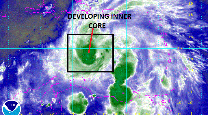
We continue to see Hurricane Matthew strengthening this evening. The pressure has fallen 8mb in the past 3 hours which is actually a sign that it may be strengthening rapidly. The satellite loop below shows the beginnings of a central inner core developing.

Hurricane Matthew appears to be defying the moderate shear that exists right now in the Eastern Caribbean. We also continue to see flight level winds of 80 knots or higher being reported north of the center. This tells me that Hurricane Matthew is defying the environment it is in and in a world all its own. Strengthening should continue and don’t be surprised if Hurricane Matthew becomes a major hurricane at some point in its life cycle.

BULLETIN
HURRICANE MATTHEW INTERMEDIATE ADVISORY NUMBER   6A
NWS NATIONAL HURRICANE CENTER MIAMI FL       AL142016
800 PM AST THU SEP 29 2016

...HURRICANE MATTHEW GRADUALLY BECOMING BETTER ORGANIZED...
...HEADING FOR THE CENTRAL CARIBBEAN SEA...


SUMMARY OF 800 PM AST...0000 UTC...INFORMATION
----------------------------------------------
LOCATION...14.2N 68.1W
ABOUT 150 MI...240 KM NNE OF CURACAO
MAXIMUM SUSTAINED WINDS...75 MPH...120 KM/H
PRESENT MOVEMENT...W OR 270 DEGREES AT 15 MPH...24 KM/H
MINIMUM CENTRAL PRESSURE...987 MB...29.15 INCHES


WATCHES AND WARNINGS
--------------------
CHANGES WITH THIS ADVISORY:

None.

SUMMARY OF WATCHES AND WARNINGS IN EFFECT:

A Tropical Storm Watch is in effect for...
* Bonaire, Curacao, and Aruba
* Colombia/Venezuela border to Riohacha

A Tropical Storm Watch means that tropical storm conditions are
possible within the watch area, in this case within the next 24 to
36 hours.

Interests elsewhere along the coasts of Venezuela and Colombia
should monitor the progress of Matthew.  Interests in Jamaica,
Hispaniola, and eastern Cuba should also monitor the progress of
Matthew.

For storm information specific to your area, please monitor products
issued by your national meteorological service.


DISCUSSION AND 48-HOUR OUTLOOK
------------------------------
At 800 PM AST (0000 UTC), the center of Hurricane Matthew was
located near latitude 14.2 North, longitude 68.1 West.  Matthew
is moving toward the west near 15 mph (24 km/h).  A westward to
west-southwestward motion with some decrease in forward speed is
expected during the next couple of days.

Maximum sustained winds remain near 75 mph (120 km/h) with higher
gusts.  Gradual strengthening is expected during the next 48 hours.

Hurricane-force winds extend outward up to 70 miles (110 km) from
the center and tropical-storm-force winds extend outward up to 185
miles (295 km).

The minimum central pressure recently reported by an Air Force
reconnaissance aircraft was 987 mb (29.15 inches).


HAZARDS AFFECTING LAND
----------------------
WIND:  Tropical storm conditions are possible in Bonaire, Curacao,
and Aruba tonight and Friday.  Tropical storm conditions are
possible over portions of the watch area in Colombia beginning
Friday.

RAINFALL: Rainfall associated with Matthew will continue to diminish
across the Lesser Antilles this evening.  Isolated additional
rainfall amounts of 2 to 4 inches are possible over the southern
Windward Islands.  Rainfall totals of 2 to 4 inches with isolated
higher amounts are expected over Aruba, Bonaire and Curacao through
Saturday.

SURF:  Swells generated by Matthew are expected to affect portions
of the coasts of Puerto Rico, Hispaniola, Aruba, Bonaire, Curacao,
Venezuela, and Colombia during the next few days.  These swells are
likely to cause life-threatening surf and rip current conditions.
Please consult products from your local weather office.
We will await the next run of weather models that begin around 11:30pm Eastern Time.
WINTER 2016-2017 PART 1 OCEAN WATER TEMPERATURES
WINTER 2016-2017 PART 2 ARCTIC SEA ICE AND SIBERIAN SNOW COVER
WINTER 2016-2017 PART 3 NEW JERSEY PREVIEW
WINTER 2016-2017 PART 4 EASTERN PENNSYLVANIA PREVIEW
FiOS1 News Weather Forecast For Long Island
FiOS1 News Weather Forecast For New Jersey
FiOS1 News Weather Forecast For Hudson Valley
NATIONAL WEATHER SERVICE SNOW FORECASTS
LATEST JOESTRADAMUS ON THE LONG RANGE
Weather App

Don’t be without Meteorologist Joe Cioffi’s weather app. It is really a meteorologist app because you get my forecasts and my analysis and not some automated computer generated forecast based on the GFS model. This is why your app forecast changes every 6 hours. It is model driven with no human input at all. It gives you an icon, a temperature and no insight whatsoever.
It is a complete weather app to suit your forecast needs. All the weather information you need is right on your phone. Android or I-phone, use it to keep track of all the latest weather information and forecasts. This weather app is also free of advertising so you don’t have to worry about security issues with your device. An accurate forecast and no worries that your device is being compromised.
Use it in conjunction with my website and my facebook and twitter and you have complete weather coverage of all the latest weather and the long range outlook. The website has been redone and upgraded. Its easy to use and everything is archived so you can see how well Joe does or doesn’t do when it comes to forecasts and outlooks.
Just click on the google play button or the apple store button on the sidebar for my app which is on My Weather Concierge. Download the app for free. Subscribe to my forecasts on an ad free environment for just 99 cents a month.
Get my forecasts in the palm of your hand for less than the cost of a cup of Joe!
![]()
![]()