Hurricane Matthew In Eastern Caribbean
Hurricane Matthew In Eastern Caribbean
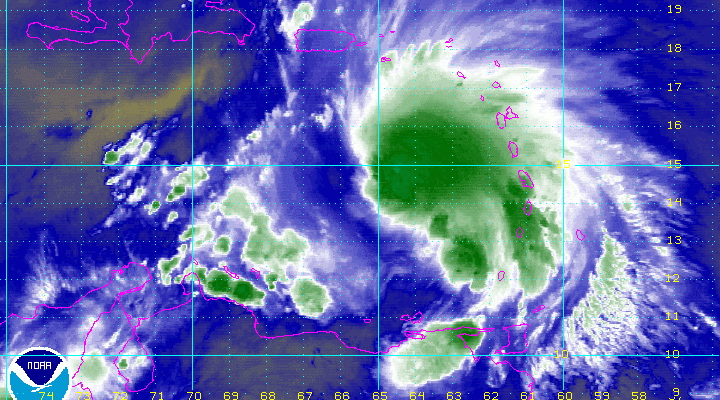
Based on the latest reconnaissance aircraft reports of a pressure of 993mb and flight level winds above hurricane force, Tropical Storm Matthew is now Hurricane Matthew as it continues to move westward.
000
URNT12 KNHC 291714
VORTEX DATA MESSAGE   AL142016
A. 29/16:43:00Z
B. 14 deg 10 min N
  066 deg 42 min W
C. 850 mb 1374 m
D. 40 kt
E. 213 deg 13 nm
F. 295 deg 45 kt
G. 207 deg 8 nm
H. 993 mb
I. 17 C / 1524 m
J. 20 C / 1529 m
K. 14 C / NA
L. NA
M. NA
N. 1345 / 8
O. 0.02 / 4 nm
P. AF303 0414A MATTHEW            OB 19
MAX OUTBOUND AND MAX FL WIND 76 KT 045 / 56 NM 17:01:30Z
CNTR DROPSONDE SFC WIND 035 / 4 KT
;

Satellite loops show an inner core developing and deepening continues at the rate of about 1 mb an hour. Gradual strengthening is forecast over the next few days. Matthew could become a major hurricane in the Central Caribbean. We will be examining the latest weather models and will post about them once the European model cycle is done.

BULLETIN
HURRICANE MATTHEW INTERMEDIATE ADVISORY NUMBER   5A
NWS NATIONAL HURRICANE CENTER MIAMI FL       AL142016
200 PM AST THU SEP 29 2016

...MATTHEW STRENGTHENS INTO A HURRICANE...


SUMMARY OF 200 PM AST...1800 UTC...INFORMATION
----------------------------------------------
LOCATION...14.2N 67.0W
ABOUT 190 MI...300 KM NE OF CURACAO
MAXIMUM SUSTAINED WINDS...75 MPH...120 KM/H
PRESENT MOVEMENT...W OR 270 DEGREES AT 17 MPH...28 KM/H
MINIMUM CENTRAL PRESSURE...993 MB...29.32 INCHES


WATCHES AND WARNINGS
--------------------
CHANGES WITH THIS ADVISORY:

None.

SUMMARY OF WATCHES AND WARNINGS IN EFFECT:

A Tropical Storm Watch is in effect for...
* Bonaire, Curacao, and Aruba

A Tropical Storm Watch means that tropical storm conditions are
possible within the watch area.

Interests along the coasts of Venezuela and Colombia should monitor
the progress of Matthew.

For storm information specific to your area, please monitor
products issued by your national meteorological service.


DISCUSSION AND 48-HOUR OUTLOOK
------------------------------
At 200 PM AST (1800 UTC), the center of Hurricane Matthew was
located near latitude 14.2 North, longitude 67.0 West.  Matthew is
moving toward the west near 17 mph (28 km/h), and a general westward
motion with some decrease in forward speed is expected during the
next couple of days.

Reports from an Air Force Reserve Hurricane Hunter aircraft indicate
that the maximum sustained winds have increased to near 75 mph (110
km/h) with higher gusts.  Gradual strengthening is expected during
the next 48 hours.

Hurricane-force-winds extend outward up to 70 miles (110 km) from
the center.  Tropical-storm-force winds extend outward up to 205
miles (335 km) from the center.  NOAA buoy 42059 has recently
reported sustained winds of 47 mph (76 km/h) with a gust to
54 mph (86 km/h).

The latest minimum central pressure reported by the Hurricane Hunter
aircraft was 993 mb (29.32 inches).


HAZARDS AFFECTING LAND
----------------------
WIND:  Tropical storm conditions are possible in Bonaire, Curacao,
and Aruba beginning late today.

RAINFALL: Rainfall associated with Matthew will begin to diminish
across the Lesser Antilles this afternoon, with additional amounts
of an inch or less expected.  Rainfall totals of 2 to 4 inches with
isolated higher amounts are expected over Aruba, Bonaire and Curacao
through Saturday.

SURF:  Swells generated by Matthew are expected to affect portions
of the coasts of Puerto Rico, Hispaniola, Aruba, Bonaire, Curacao,
Venezuela, and Colombia during the next few days.  These swells are
likely to cause life-threatening surf and rip current conditions.
Please consult products from your local weather office.


NEXT ADVISORY
-------------
Next complete advisory at 500 PM AST.

$$
Forecaster Brown/Pasch
WINTER 2016-2017 PART 1 OCEAN WATER TEMPERATURES
WINTER 2016-2017 PART 2 ARCTIC SEA ICE AND SIBERIAN SNOW COVER
WINTER 2016-2017 PART 3 NEW JERSEY PREVIEW
WINTER 2016-2017 PART 4 EASTERN PENNSYLVANIA PREVIEW
FiOS1 News Weather Forecast For Long Island
FiOS1 News Weather Forecast For New Jersey
FiOS1 News Weather Forecast For Hudson Valley
NATIONAL WEATHER SERVICE SNOW FORECASTS
LATEST JOESTRADAMUS ON THE LONG RANGE
Weather App

Don’t be without Meteorologist Joe Cioffi’s weather app. It is really a meteorologist app because you get my forecasts and my analysis and not some automated computer generated forecast based on the GFS model. This is why your app forecast changes every 6 hours. It is model driven with no human input at all. It gives you an icon, a temperature and no insight whatsoever.
It is a complete weather app to suit your forecast needs. All the weather information you need is right on your phone. Android or I-phone, use it to keep track of all the latest weather information and forecasts. This weather app is also free of advertising so you don’t have to worry about security issues with your device. An accurate forecast and no worries that your device is being compromised.
Use it in conjunction with my website and my facebook and twitter and you have complete weather coverage of all the latest weather and the long range outlook. The website has been redone and upgraded. Its easy to use and everything is archived so you can see how well Joe does or doesn’t do when it comes to forecasts and outlooks.
Just click on the google play button or the apple store button on the sidebar for my app which is on My Weather Concierge. Download the app for free. Subscribe to my forecasts on an ad free environment for just 99 cents a month.
Get my forecasts in the palm of your hand for less than the cost of a cup of Joe!
![]()
![]()