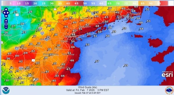
High Wind Warning Wind Advisory Winds Gust 60 MPH Or Higher
The major storm impacting the Eastern Seaboard is still at this morning. Overnight rains have generally moved offshore however we are seeing a large area of heavy precipitation both rain and snow in Central and Western Pennsylvania as well as into Upstate NY. The big story today for most will be the wind especially along coastal areas. High Wind Warnings are up for Coastal New Jersey to NYC & Long Island extending to Southeast New England.
Look for the strongest winds to occur between 2pm and 6pm this evening and this will come once the storm center passes north of NYC which it will do after 1pm today according to the new NAM model.
When you look at the satellite picture this morning what is interesting is you can see what looks like cloud streaks or lines across Pennsylvania down into Maryland an Virginia. This is a signature of a strong storm. We also see the development of a “comma head” structure which is another satellite signature of strength.
SATELLITE
REGIONAL RADAR
The structure of the storm is why you see precipitation still going on the regional radar and in fact on the eastern flank of this shield are some thunderstorms and we have even seen a few severe thunderstorm warnings from this. Most of this will be confined to areas west and north of NYC & Philadelphia. West of I-81 a change to snow is likely and we could see some bursts of heavy snow there for a few hours.
LOCAL RADAR NEW YORK CITY
LOCAL RADAR PHILADELPHIA

In general near the coast the rains are done and will see whatever clouds and moisture around this morning exit rather quickly once the winds shift to the west and northwest later today. Temperatures are in the 40s to near 50 now but they will drop into the 30s once the wind shifts and colder air arrives.
it is also possible that we could see some snow into Northeast Pennsylvania and Northwest New Jersey northeast into the Catskills late this morning into this afternoon as the comma head of the low moves overhead. This could create a quick burst of snow and we can’t rule out the chance for a coating to an inch or so with higher amounts as you head north and northwest. Heavy snows continue to favor areas in Upstate NY and into New England mainly north of I -90.
There are no issues for the weekend. Weather conditions improve Saturday with less wind and some sunshine with highs in the 30s. Sunday look for sun and arriving clouds with highs in the upper 30s and lower 40s. The next front brings a chance for showers on Monday.
BE SURE TO DOWNLOAD THE FREE METEOROLOGIST JOE CIOFFI WEATHER APP &
ANGRY BEN’S FREE WEATHER APP “THE ANGRY WEATHERMAN!
MANY THANKS TO TROPICAL TIDBITS FOR THE USE OF MAPS
Please note that with regards to any severe weather, tropical storms, or hurricanes, should a storm be threatening, please consult your local National Weather Service office or your local government officials about what action you should be taking to protect life and property.


