Flood Watches Wind Advisories Major Storm Impacting East Coast Florida to Maine
A major storm is ripping through the Eastern US tonight and Friday and it is having a large impact from Maine to Florida. Everything from heavy snow in the north to tornadoes and severe thunderstorms in the south are on the menu and heavy rains/flash flooding for areas in between.
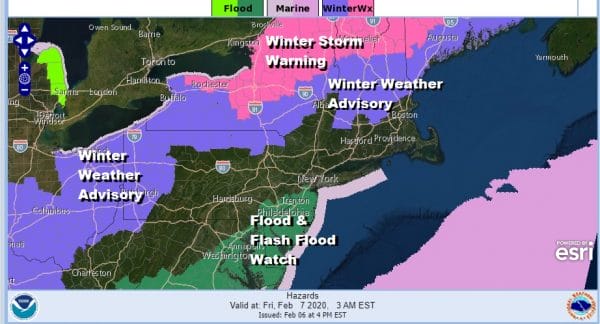
Tonight it is mostly about rain for Eastern Pennsylvania to Southern New England and Flood Watches continue for New Jersey mainly south and east of Route 78. We will finish up with some areas getting a couple of inches of rain total. Winter weather is the issue in upstate NY north of I-90 as well as Western NY & Western Pennsylvania as they wait for rain to change to snow there. New England will see ice going over to snow overnight and on Friday.
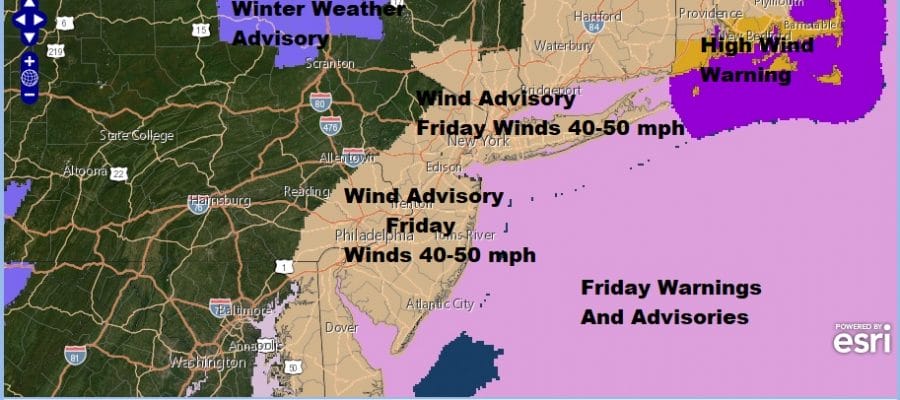
Friday the issue will be the wind and wind advisories are posted from Delaware to Southern New England with 40 to 50 mph gusts likely. An intense storm will be moving over NYC (or nearby) Monday morning and the winds will howl from the northwest once the low moves to the northeast.
Snow lovers and skiers will have to go north up to at least I-90 to find anything of consequence in NY State and well west of I-81 IN Pennsylvania. Northern New England should do rather well with this storm with 1 foot plus snows likely.
SATELLITE
REGIONAL RADAR
Here of course the story is rain as we watch the regional and local radars really loading up with moderate to heavy rain to the south of NYC and moving northeastward. The worst of the rain will be overnight but most of it should be done by 6 or 7am. There still might be some showers around into early afternoon. Inland areas might see it go over to some snow showers in NW New Jersey, Northeast Pennsylvania into the Hudson Valley and Western Connecticut.
LOCAL RADAR NEW YORK CITY
LOCAL RADAR PHILADELPHIA

Once this storm is done we should head into the weekend with quiet and cold weather. Temperatures tonight could rise into the 50s before dropping into the 30s later Friday. Saturday;s highs will be in the 30s with some sunshine and less wind. Sunday could see some clouds around with highs in the upper 30s to lower 40s. The next cold front begins its approach early next week with a chance for showers on Monday. If the front stalls we could see another wave bring a chance for some rain (maybe a little snow inland) for Tuesday.
BE SURE TO DOWNLOAD THE FREE METEOROLOGIST JOE CIOFFI WEATHER APP &
ANGRY BEN’S FREE WEATHER APP “THE ANGRY WEATHERMAN!
MANY THANKS TO TROPICAL TIDBITS FOR THE USE OF MAPS
Please note that with regards to any severe weather, tropical storms, or hurricanes, should a storm be threatening, please consult your local National Weather Service office or your local government officials about what action you should be taking to protect life and property.


