Hermine Threat NYC New Jersey Long Island
Hermine Threat NYC New Jersey Long Island
Tropical Storm Warnings For Both Coasts of Florida
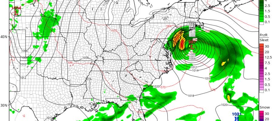
Weather models this afternoon continue to converge on a solution regarding Hermine. The general idea is that this tropical storm will move off the North Carolina coast Saturday night and head northeast until it comes to a crashing halt somewhere east of Cape May New Jersey and South of Montauk during Sunday. The storm will then make a westward hook in an attempt to make some sort of a loop that may take a day or two to play out.
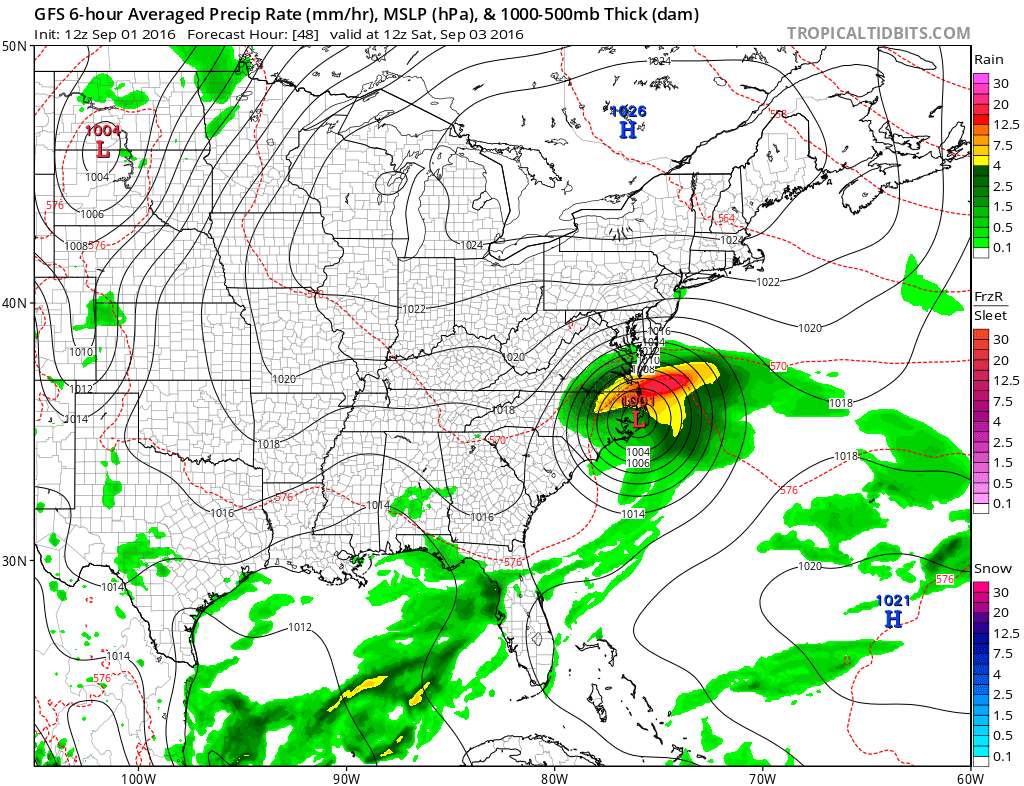

As of right now no direct landfall is expected however having a strong Tropical Storm sitting a position just offshore will produce stormy conditions for Long Island and Southernmost New England to New York City and then southward across Central and Southern New Jersey southward to along the Middle Atlantic Coast.
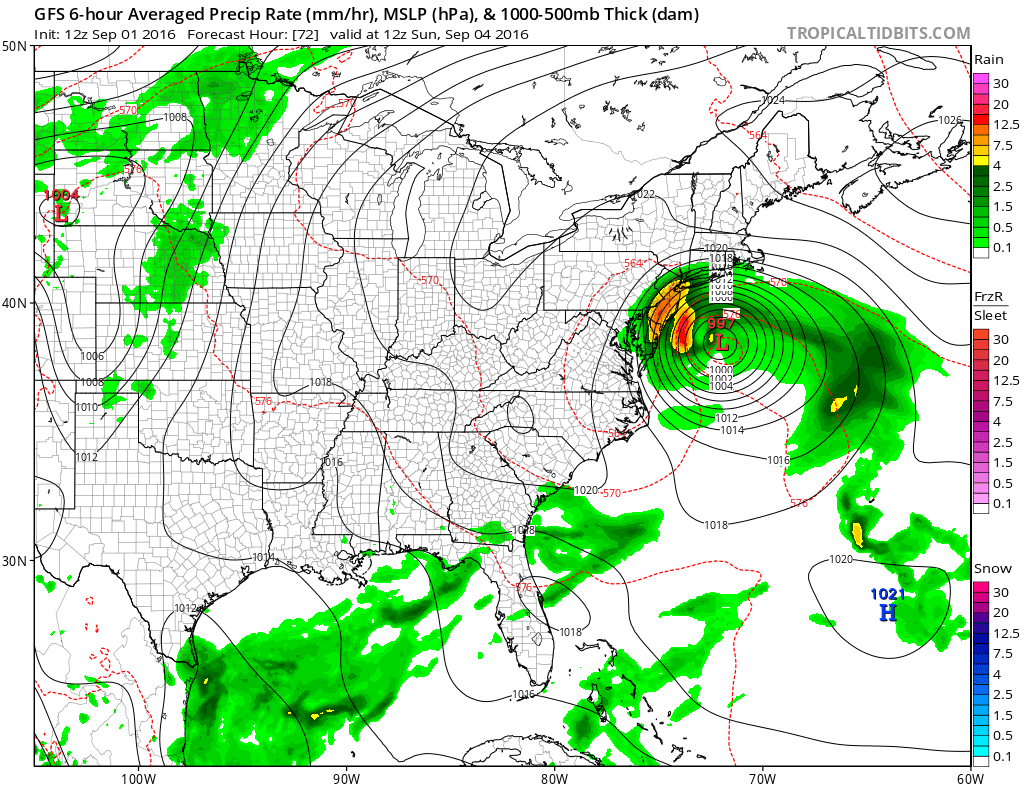
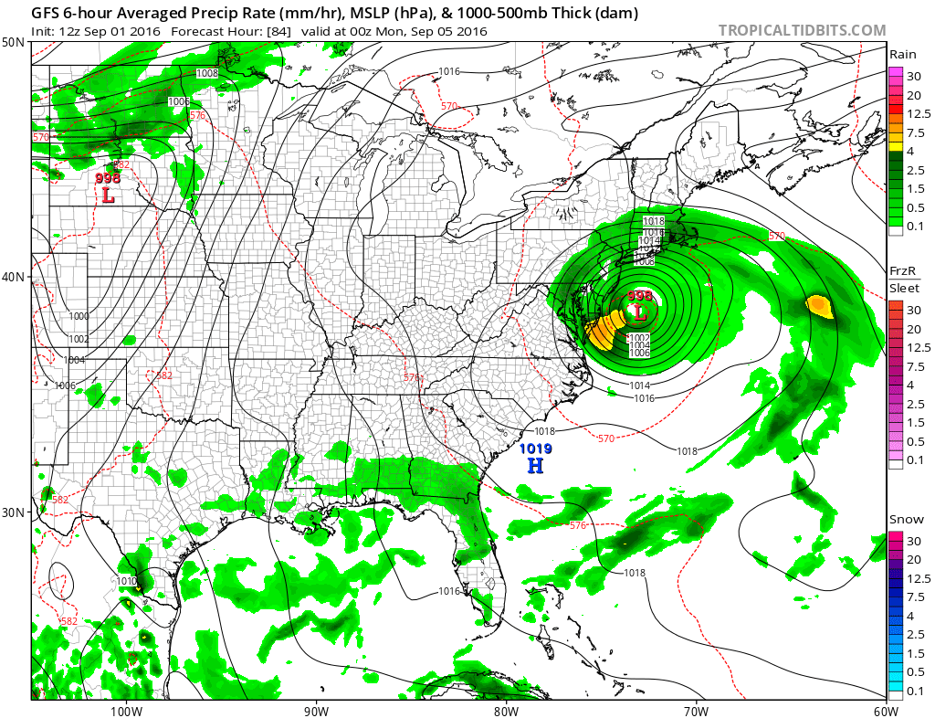
The GFS model sequence above is the most aggressive. All the models have this idea in some form with positioning being the issue. The implications of this type of track would be for wind and rain to being along coastal New Jersey Saturday and the spread to New York City Long Island and Southern New England by Sunday morning. Sunday we will see according to the gfs winds of gale force with gusts to 50 mph or more possible. I think that coastal New Jersey could fare worse in terms of time since the storms loop effects that coastline for a longer period of time.
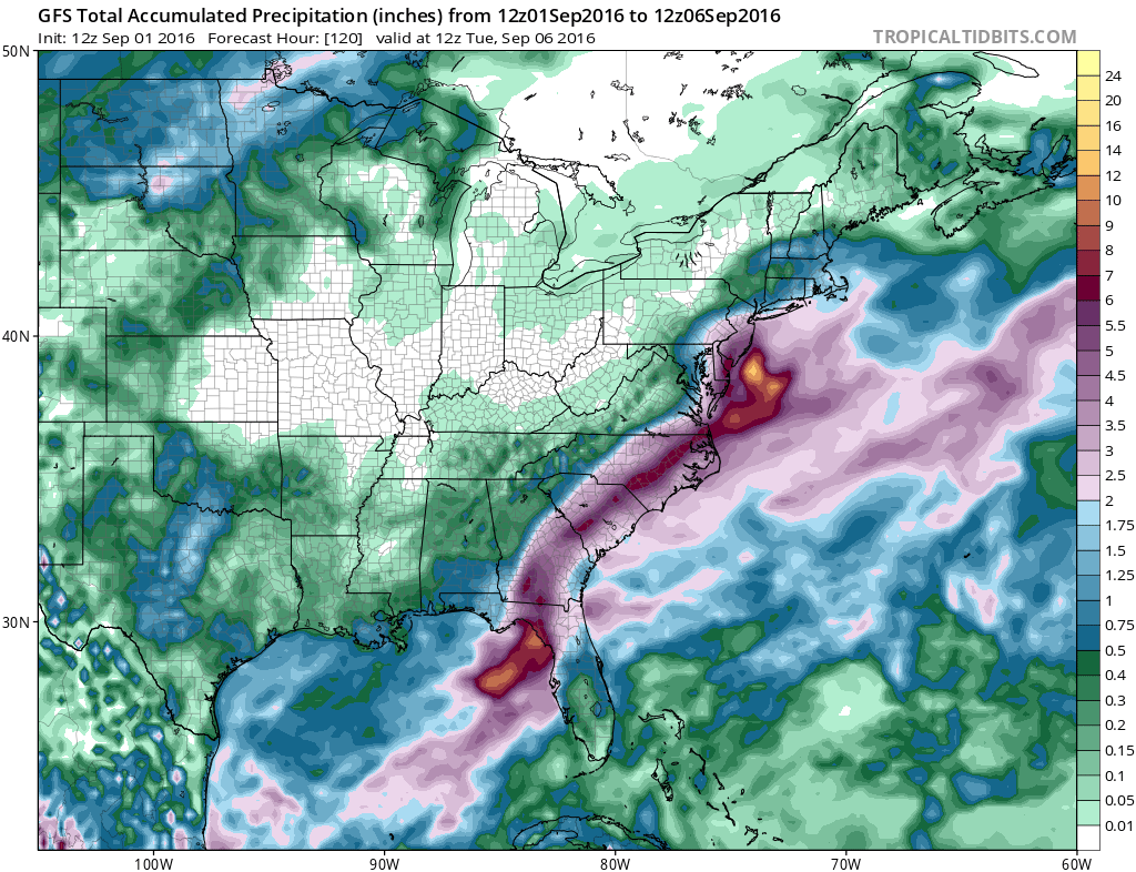
Rainfall amounts of 2 to 4 inces will occur on the northern fringe with lesser amounts as you go north into Northwest New Jersey and the Hudson Valley with 4 to 6 inch or higher amounts to the south. This potentially could be a drought breaker if this northernmost track holds.
Some models transition this into a hybrid type storm for awhile before turning it purely tropical again after the southward drift. The European model strongly implies this. Such a transition could change the profile some but we will deal with that when we get there.

TROPICAL STORM WARNINGS EXTENDED TO ALL OF SOUTH FLORIDA
The storms gales have expanded on the Eastern Side prompting Tropical Storm Warnings to be issued for all of South Florida.
TROPICAL STORM HERMINE SPECIAL ADVISORY NUMBER  17...CORRECTED
NWS NATIONAL HURRICANE CENTER MIAMI FL       AL092016
1200 PM CDT THU SEP 01 2016

CORRECTED TO REPLACE ARIPEKA WITH LONGBOAT KEY IN FIRST
PARAGRAPH OF STORM SURGE HAZARD STATEMENT

...TROPICAL STORM WARNING EXTENDED SOUTHWARD ALONG FLORIDA GULF AND
ATLANTIC COASTS...


SUMMARY OF 1200 PM CDT...1700 UTC...INFORMATION
-----------------------------------------------
LOCATION...27.8N 85.6W
ABOUT 135 MI...220 KM SSW OF APALACHICOLA FLORIDA
ABOUT 190 MI...305 KM W OF TAMPA FLORIDA
MAXIMUM SUSTAINED WINDS...70 MPH...110 KM/H
PRESENT MOVEMENT...NNE OR 30 DEGREES AT 14 MPH...22 KM/H
MINIMUM CENTRAL PRESSURE...989 MB...29.21 INCHES


WATCHES AND WARNINGS
--------------------
CHANGES WITH THIS ADVISORY:

The Tropical Storm Warning has been extended southward along the
west coast of Florida to Englewood, including the greater Tampa/St.
Petersburg area, and southward along the east coast of Florida to
the Flagler/Volusia County line.

SUMMARY OF WATCHES AND WARNINGS IN EFFECT:

A Hurricane Warning is in effect for...
* Suwannee River to Mexico Beach

A Hurricane Watch is in effect for...
* Anclote River to Suwannee River
* West of Mexico Beach to the Walton/Bay County line

A Tropical Storm Warning is in effect for...
* Englewood to Suwannee River
* West of Mexico Beach to the Walton/Bay County line
* Flagler/Volusia County line to Surf City

A Tropical Storm Watch is in effect for...
* North of Surf City to Oregon Inlet, including Pamlico Sound

Interests elsewhere along the United States mid-Atlantic and
northeast coast should monitor the progress of this system.

For storm information specific to your area, including possible
inland watches and warnings, please monitor products issued by your
local National Weather Service forecast office.


DISCUSSION AND 48-HOUR OUTLOOK
------------------------------
At 1200 PM CDT (1700 UTC), the center of Tropical Storm Hermine was
located near latitude 27.8 North, longitude 85.6 West.  Hermine is
moving toward the north-northeast near 14 mph (22 km/h), and this
motion with a slight increase in forward speed is expected during
the next day or so.  On the forecast track, the center of Hermine
will be near the Florida coast in the hurricane warning area tonight
or early Friday.

Maximum sustained winds are near 70 mph (110 km/h) with higher
gusts.  Additional strengthening is anticipated, and Hermine is
expected to be a hurricane by the time landfall occurs.

Tropical-storm-force winds extend outward up to 185 miles (295 km),
mainly to the northeast and southeast of the center.

The estimated minimum central pressure is 989 mb (29.21 inches).

This Special Advisory replaces the intermediate advisory that would
have been issued at 100 PM CDT.
FiOS1 News Weather Forecast For Long Island
FiOS1 News Weather Forecast For New Jersey
FiOS1 News Weather Forecast For Hudson Valley
NATIONAL WEATHER SERVICE SNOW FORECASTS
LATEST JOESTRADAMUS ON THE LONG RANGE
Weather App

Don’t be without Meteorologist Joe Cioffi’s weather app. It is really a meteorologist app because you get my forecasts and my analysis and not some automated computer generated forecast based on the GFS model. This is why your app forecast changes every 6 hours. It is model driven with no human input at all. It gives you an icon, a temperature and no insight whatsoever.
It is a complete weather app to suit your forecast needs. All the weather information you need is right on your phone. Android or I-phone, use it to keep track of all the latest weather information and forecasts. This weather app is also free of advertising so you don’t have to worry about security issues with your device. An accurate forecast and no worries that your device is being compromised.
Use it in conjunction with my website and my facebook and twitter and you have complete weather coverage of all the latest weather and the long range outlook. The website has been redone and upgraded. Its easy to use and everything is archived so you can see how well Joe does or doesn’t do when it comes to forecasts and outlooks.
Just click on the google play button or the apple store button on the sidebar for my app which is on My Weather Concierge. Download the app for free. Subscribe to my forecasts on an ad free environment for just 99 cents a month.
Get my forecasts in the palm of your hand for less than the cost of a cup of Joe!
![]()
![]()