Hermine Early Storm Surge Forecast
Tropical Storm Hermine Winds 65 MPH
Landfall over Florida Coastal Bend Tonight
East Coast Threat Labor Day Weekend

...HERMINE HEADING FOR THE NORTH FLORIDA GULF COAST...
...LIFE-THREATENING SURGE AND FLOODING RAINS EXPECTED...


SUMMARY OF 1000 AM CDT...1500 UTC...INFORMATION
-----------------------------------------------
LOCATION...27.4N 86.0W
ABOUT 170 MI...275 KM SSW OF APALACHICOLA FLORIDA
ABOUT 220 MI...350 KM W OF TAMPA FLORIDA
MAXIMUM SUSTAINED WINDS...65 MPH...100 KM/H
PRESENT MOVEMENT...NNE OR 30 DEGREES AT 14 MPH...22 KM/H
MINIMUM CENTRAL PRESSURE...991 MB...29.27 INCHES


WATCHES AND WARNINGS
--------------------
CHANGES WITH THIS ADVISORY:

The Tropical Storm Warning has been extended northward for the
Atlantic coast to Surf City North Carolina.  A  Tropical Storm Watch
has been issued north of Surf City to Oregon Inlet North Carolina,
including Pamlico Sound.  The Hurricane Watch and Tropical Storm
Warning have been discontinued west of the Walton/Bay County line.

SUMMARY OF WATCHES AND WARNINGS IN EFFECT:

A Hurricane Warning is in effect for...
* Suwannee River to Mexico Beach

A Hurricane Watch is in effect for...
* Anclote River to Suwannee River
* West of Mexico Beach to the Walton/Bay County line

A Tropical Storm Warning is in effect for...
* Anclote River to Suwannee River
* West of Mexico Beach to the Walton/Bay County line
* Marineland to Surf City

A Tropical Storm Watch is in effect for...
* North of Surf City to Oregon Inlet, including Pamlico Sound

Interests elsewhere along the United States mid-Atlantic and
northeast coast should monitor the progress of this system.

For storm information specific to your area, including possible
inland watches and warnings, please monitor products issued by your
local National Weather Service forecast office.


DISCUSSION AND 48-HOUR OUTLOOK
------------------------------
At 1000 AM CDT (1500 UTC), the center of Tropical Storm Hermine was
located near latitude 27.4 North, longitude 86.0 West.  Hermine is
moving toward the north-northeast near 14 mph (22 km/h), and this
motion with a slight increase in forward speed is expected during
the next day or so.  On the forecast track, the center of Hermine
will be near the Florida coast in the hurricane warning area tonight
or early Friday.

Maximum sustained winds are near 65 mph (100 km/h) with higher
gusts.   Additional strengthening is anticipated, and Hermine is
expected to be a hurricane by the time landfall occurs.

Tropical-storm-force winds extend outward up to 140 miles (220 km)
from the center.

An Air Force Hurricane Hunter aircraft recently reported a minimum
central pressure of 991 mb (29.27 inches).
You can see on the satellite loop how the alley way up the east coast is being set up. A cold front is moving through us and the clouds arc down into the Tennessee Valley. Meanwhile you can see tropical moisture from the Eastern Gulf of Mexico which includes Hermine. And we have an zone of clouds which includes the late tropical depression 8 that extends from the southeast coast of the US out northeastward to off Nova Scotia.

We can say that at least our weather will improve this afternoon with a gradual decrease in clouds and an increase in sunshine. It may take all day for that to happen in eastern areas however. Then it is clear tonight and sunshine for Friday with highs in the 70s and low humidity.
Saturday we will being to see sky conditions deteriorate from approaching Hermine. Then it depends on track from there as to how much rain and wind and how far north and west of a track, and all the other questions that we can’t really answer definitively at this point.

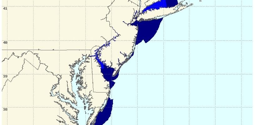
The National Weather Service has a new tool which can help in predicting storm surge. You can link to it by clicking on the graphic above. Based on the overnight forecast this is a model prediction of storm surge with tide heights. Numbers are smoothed out a bit using tide data over long periods of time to determine mean high and mean low water. This outlook will change of course as forecasts change and this is only through early Sunday morning. It suggests 3 foot surges in areas in blue and 5 feet in the light blue. Again this is through Sunday morning and will change as forecast models change. This does not include wave action.
Finally this satellite view below shows a circulation with a tropical wave off the African coast. There is clearly a low there but there is also lots of dry air and dust that is preventing development. We will have to see what happens to this as it gets further to the west.

FiOS1 News Weather Forecast For Long Island
FiOS1 News Weather Forecast For New Jersey
FiOS1 News Weather Forecast For Hudson Valley
NATIONAL WEATHER SERVICE SNOW FORECASTS
LATEST JOESTRADAMUS ON THE LONG RANGE
Weather App

Don’t be without Meteorologist Joe Cioffi’s weather app. It is really a meteorologist app because you get my forecasts and my analysis and not some automated computer generated forecast based on the GFS model. This is why your app forecast changes every 6 hours. It is model driven with no human input at all. It gives you an icon, a temperature and no insight whatsoever.
It is a complete weather app to suit your forecast needs. All the weather information you need is right on your phone. Android or I-phone, use it to keep track of all the latest weather information and forecasts. This weather app is also free of advertising so you don’t have to worry about security issues with your device. An accurate forecast and no worries that your device is being compromised.
Use it in conjunction with my website and my facebook and twitter and you have complete weather coverage of all the latest weather and the long range outlook. The website has been redone and upgraded. Its easy to use and everything is archived so you can see how well Joe does or doesn’t do when it comes to forecasts and outlooks.
Just click on the google play button or the apple store button on the sidebar for my app which is on My Weather Concierge. Download the app for free. Subscribe to my forecasts on an ad free environment for just 99 cents a month.
Get my forecasts in the palm of your hand for less than the cost of a cup of Joe!
![]()
![]()