Hermine Nears Hurricane Force
GFS OVERNIGHT MODEL VIDEO ON TROPICAL STORM HERMINE
Hermine Nears Hurricane Force
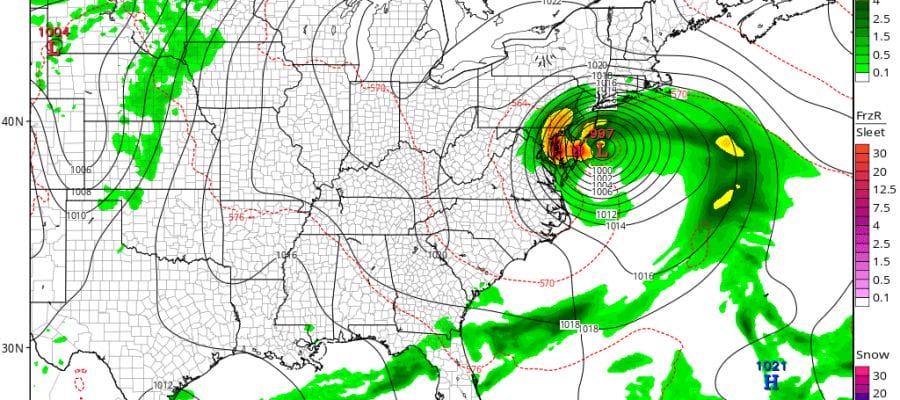
Mid Run GFS Model Goes Left
European Model Stalls Offshore
This morning’s latest report from a NOAA plane shows a pressure of 994 mb and a flight level wind of 66 knots so Hermine is getting close to hurricane strength. The track toward the north northeast continues at around 11 mph or so. No real big changes on the advisory.

...HERMINE HEADING TOWARD THE NORTH FLORIDA COAST...


SUMMARY OF 400 AM CDT...0900 UTC...INFORMATION
----------------------------------------------
LOCATION...26.4N 86.6W
ABOUT 250 MI...400 KM SSW OF APALACHICOLA FLORIDA
ABOUT 275 MI...440 KM WSW OF TAMPA FLORIDA
MAXIMUM SUSTAINED WINDS...60 MPH...95 KM/H
PRESENT MOVEMENT...NNE OR 20 DEGREES AT 12 MPH...19 KM/H
MINIMUM CENTRAL PRESSURE...996 MB...29.42 INCHES


WATCHES AND WARNINGS
--------------------
CHANGES WITH THIS ADVISORY:

A Tropical Storm Warning has been issued for the U.S. east
coast from Marineland Florida to South Santee River South Carolina.

A Tropical Storm Watch has been issued for the U.S. east
coast from north of South Santee River to Surf City North Carolina.

SUMMARY OF WATCHES AND WARNINGS IN EFFECT:

A Hurricane Warning is in effect for...
* Suwannee River to Mexico Beach

A Hurricane Watch is in effect for...
* Anclote River to Suwannee River
* West of Mexico Beach to Destin

A Tropical Storm Warning is in effect for...
* Anclote River to Suwannee River
* West of Mexico Beach to Destin
* Marineland to South Santee River

A Tropical Storm Watch is in effect for...
* North of South Santee River to Surf City

Interests along the United States east coast elsewhere in North
Carolina should monitor the progress of this system.

For storm information specific to your area, including possible
inland watches and warnings, please monitor products issued by your
local National Weather Service forecast office.


DISCUSSION AND 48-HOUR OUTLOOK
------------------------------
At 400 AM CDT (0900 UTC), the center of Tropical Storm Hermine was
located near latitude 26.4 North, longitude 86.6 West. Hermine is
moving toward the north-northeast near 12 mph (19 km/h), and this
motion with a slight increase in forward speed is expected during
the next day or so. On the forecast track, the center of Hermine
will be near the Florida coast in the warning area tonight or
early Friday.

Maximum sustained winds remain near 60 mph (95 km/h) with higher
gusts. Some strengthening is anticipated, and Hermine is expected to
be a hurricane by the time landfall occurs.

Tropical-storm-force winds extend outward up to 140 miles (220 km)
to the east of the center.

The estimated minimum central pressure from a NOAA Hurricane Hunter
plane was 996 mb (29.42 inches).
GFS MODEL SHIFTS LEFT
We are a long way from having this settled in terms of track, behavior, and weather outcome. All of this hinges on the upper low to the west and how the hurricane reacts to it. This we may not know for awhile yet. Meanwhile the GFS went left on the mid run cycle with the tropical storm tucked in further west northwest.

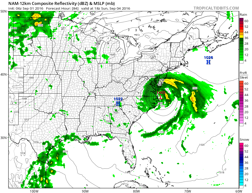
The mid run NAM model lines up with the European ovenight which was further south.
We are going to be dancing every run of this for awhile. It think at least we know nothing of consequence happens at least into Saturday evening. Also what will be key will be the speed of Hermine and when landfall occurs. This will ultimately effect how far north Hermine gets. The puzzle continues.
FiOS1 News Weather Forecast For Long Island
FiOS1 News Weather Forecast For New Jersey
FiOS1 News Weather Forecast For Hudson Valley
NATIONAL WEATHER SERVICE SNOW FORECASTS
LATEST JOESTRADAMUS ON THE LONG RANGE
Weather App

Don’t be without Meteorologist Joe Cioffi’s weather app. It is really a meteorologist app because you get my forecasts and my analysis and not some automated computer generated forecast based on the GFS model. This is why your app forecast changes every 6 hours. It is model driven with no human input at all. It gives you an icon, a temperature and no insight whatsoever.
It is a complete weather app to suit your forecast needs. All the weather information you need is right on your phone. Android or I-phone, use it to keep track of all the latest weather information and forecasts. This weather app is also free of advertising so you don’t have to worry about security issues with your device. An accurate forecast and no worries that your device is being compromised.
Use it in conjunction with my website and my facebook and twitter and you have complete weather coverage of all the latest weather and the long range outlook. The website has been redone and upgraded. Its easy to use and everything is archived so you can see how well Joe does or doesn’t do when it comes to forecasts and outlooks.
Just click on the google play button or the apple store button on the sidebar for my app which is on My Weather Concierge. Download the app for free. Subscribe to my forecasts on an ad free environment for just 99 cents a month.
Get my forecasts in the palm of your hand for less than the cost of a cup of Joe!
![]()
![]()