Hurricane Warnings Florida & East Coast Threat Weekend
LATEST VIDEO ON TROPICAL STORM HERMINE
GFS & NAM MODEL ANALYSYS
Hurricane Warning Florida Coastal Bend
East Coast Threat Weekend
Hurricane Warnings are posted for the Florida Coastal Bend from the Suanee River to Mexico Beach which includes Panama City. Satellite and NOAA plane reports indicate Tropical Storm Hermine is strengthening with winds now 60 mph and moving north northeast. Strengthening should continue until landfall and Hermine could reach hurricane strength during Thursday.

...HERMINE CONTINUES TO STRENGTHEN OVER THE EASTERN GULF OF
MEXICO...
...HURRICANE WARNING ISSUED FOR PORTION OF NORTHWESTERN FLORIDA...


SUMMARY OF 1000 PM CDT...0300 UTC...INFORMATION
-----------------------------------------------
LOCATION...25.8N 87.0W
ABOUT 295 MI...475 KM SSW OF APALACHICOLA FLORIDA
ABOUT 315 MI...510 KM WSW OF TAMPA FLORIDA
MAXIMUM SUSTAINED WINDS...60 MPH...95 KM/H
PRESENT MOVEMENT...NNE OR 25 DEGREES AT 10 MPH...17 KM/H
MINIMUM CENTRAL PRESSURE...998 MB...29.47 INCHES


WATCHES AND WARNINGS
--------------------
CHANGES WITH THIS ADVISORY:

A Hurricane Warning has been issued from the Suwannee River westward
to Mexico Beach Florida. The Tropical Storm Watch has been extended
from Altamaha Sound Georgia northward to the South Santee River
South Carolina.

SUMMARY OF WATCHES AND WARNINGS IN EFFECT:

A Hurricane Warning is in effect for...
* Suwannee River to Mexico Beach

A Hurricane Watch is in effect for...
* Anclote River to Suwannee River
* West of Mexico Beach to Destin

A Tropical Storm Warning is in effect for...
* Anclote River to Suwannee River
* West of Mexico Beach to Destin

A Tropical Storm Watch is in effect for...
* Marineland Florida to South Santee River

Interests along the United States east coast elsewhere in the
Carolinas should monitor the progress of this system.

For storm information specific to your area, including possible
inland watches and warnings, please monitor products issued by your
local National Weather Service forecast office.


DISCUSSION AND 48-HOUR OUTLOOK
------------------------------
At 1000 PM CDT (0300 UTC), the center of Tropical Storm Hermine was
located near latitude 25.8 North, longitude 87.0 West. Hermine is
moving toward the north-northeast near 10 mph (17 km/h) and this
motion with an increase in forward speed is expected to continue
through Thursday.  On the forecast track, the center will be near
the coast in the warning area Thursday night.

Recent reports from NOAA and Air Force Reserve Hurricane Hunter
aircraft indicate that maximum sustained winds have increased to
near 60 mph (95 km/h) with higher gusts. Additional strengthening is
forecast during the next 24 to 36 hours, and Hermine is expected to
be a hurricane by the time landfall occurs.

Tropical-storm-force winds extend outward up to 125 miles (205 km)
from the center.

The minimum central pressure reported by an Air Force Reserve
Hurricane Hunter aircraft is 998 mb (29.47 inches).
HURRICANE WARNINGS & GFS MODEL ANALYSIS
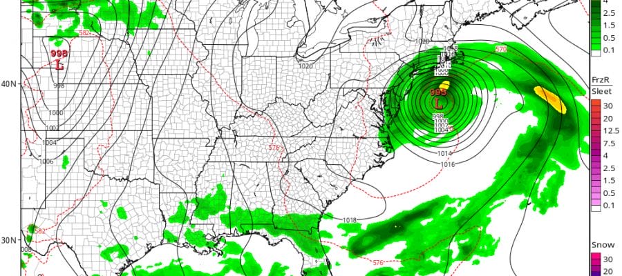
Given that the recon fixes were a little to the east models have adjusted to the east however be advised that this is an unusual and fluid situation here. We could see adjustments left or right going forward. As far as our area is concerned this will all depend on how the storm reacts to the upper low that develops to the west.
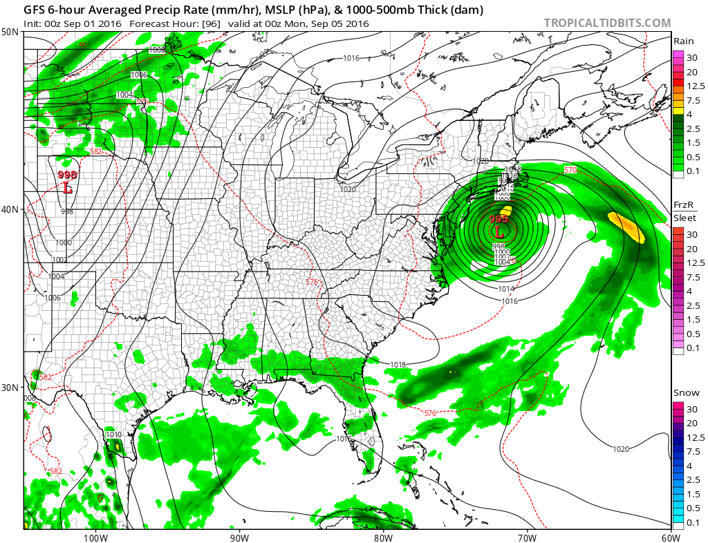
Tonight’s run takes the tropical storm to the northeast off Northeastern North Carolina and offshore and then hooks it back westward putting it in very close proximity to the coasts of New Jersey and Long Island. This would create coastal flooding and beach erosion issues since it takes another day or so for the tropical storm on this model to be ejected to the northeast.
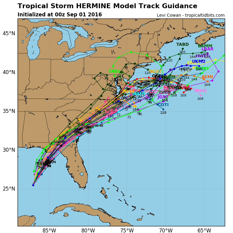
These are the latest spaghetti plots which have shifted east on this run to mostly offshore tracks though some are a bit unusual in how they move this. We will have more in the morning when we will see the European, Canadian and mid run GFS and NAM models.
FiOS1 News Weather Forecast For Long Island
FiOS1 News Weather Forecast For New Jersey
FiOS1 News Weather Forecast For Hudson Valley
NATIONAL WEATHER SERVICE SNOW FORECASTS
LATEST JOESTRADAMUS ON THE LONG RANGE
Weather App

Don’t be without Meteorologist Joe Cioffi’s weather app. It is really a meteorologist app because you get my forecasts and my analysis and not some automated computer generated forecast based on the GFS model. This is why your app forecast changes every 6 hours. It is model driven with no human input at all. It gives you an icon, a temperature and no insight whatsoever.
It is a complete weather app to suit your forecast needs. All the weather information you need is right on your phone. Android or I-phone, use it to keep track of all the latest weather information and forecasts. This weather app is also free of advertising so you don’t have to worry about security issues with your device. An accurate forecast and no worries that your device is being compromised.
Use it in conjunction with my website and my facebook and twitter and you have complete weather coverage of all the latest weather and the long range outlook. The website has been redone and upgraded. Its easy to use and everything is archived so you can see how well Joe does or doesn’t do when it comes to forecasts and outlooks.
Just click on the google play button or the apple store button on the sidebar for my app which is on My Weather Concierge. Download the app for free. Subscribe to my forecasts on an ad free environment for just 99 cents a month.
Get my forecasts in the palm of your hand for less than the cost of a cup of Joe!
![]()
![]()